 Website:
Wuxi Bewis Sensing Tecnology LLC
Group: BWSENSING
Catalog excerpts

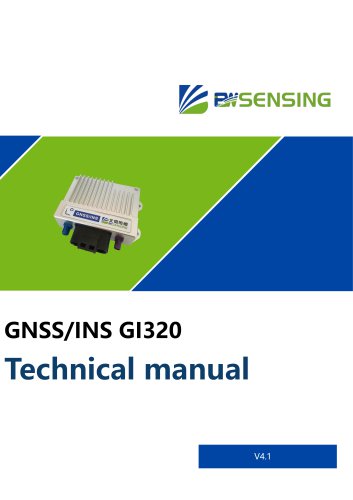
Cost-effective Integrated Navigation System GI320 Introduction GI320 adopts loose coupling integrated navigation technology, which deeply integrates IMU with RTK solution and observation preprocessing, and can provide real-time and high-precision navigation parameters such as position, speed and attitude. The integrated navigation algorithm uses the GPS data as initial data for operation. If GPS data is lost, the system will run the strapdown inertial navigation calculation alone, and the calculated data will be sent to the Kalman filter for processing. Feature · GNSS/INS high-precision...
Open the catalog to page 2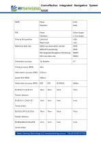
Cost-effective Integrated Navigation System GI320 Cold start Warm start GNSS raw observation volume INS Integrated Navigation Positioning Orientation accuracy RTK Time to first position Maximum data rate Pseudo-distance B1I/B1C/L1 C/A/E1/G1 Carrier phase B2I/G2/L2P(Y)/L2C/E5b Pseudo-distance B2I/B2a/B2b/L5/E5a/E5b Carrier phase Bewis Sensing Technology LLC www.bwsensing.com.cn TEL:0510-857371
Open the catalog to page 3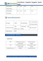
Cost-effective Integrated Navigation System GI320 B3I/L5/E5a/B2a Pseudo-distance B3I/L5/E5a/B2a Carrier phase 6 ° /h ( 10s smooth ) Gyro range Gyro Bias Stability 0.5°/h(allan variance) Accelerometer range Output frequency Communication Interface · Interface Type GNSS secondary antenna internal needle Automotive connector GNSS main antenna Automotive connector Bewis Sensing Technology LLC www.bwsensing.com.cn T
Open the catalog to page 4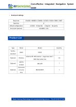
Cost-effective Integrated Navigation System GI320 Serial port settings Baud rate Data bits Default configuration Serial port optional Product List Type Factory standard Optional Antenna BT-300 antenna + large base stud + SMA feed cable (5m) connector plug Bewis Sensing Technology LLC www.bwsensing.com.cn TEL:0510-85737158
Open the catalog to page 5
Cost-effective Integrated Navigation System GI320 Installation and Requirements · Power Requirements 9~24VDC Power 10W · Connection relationship Mode configuration · Mobile station model Base station mode Automatically identify differential data input by serial port, support RTCM3.2 Differential text can also use the differential positioning service provided by Qianxun through the built-in 4g module Raw observation data output · Base station mode Bewis Sensing Technology LLC www.bwsensing.com.cn TEL:0510-85737158 Self-optimised base station coordinates, or input known coordinates and send...
Open the catalog to page 6
Cost-effective Integrated Navigation System GI320 Differential data acquisition · Qianxun SI · Self-base station Product feature Package product size Product size:116.5×74×30mm Bewis Sensing Technology LLC www.bwsensing.com.cn TEL:0510-85737
Open the catalog to page 7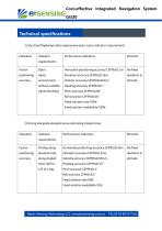
Cost-effective Integrated Navigation System GI320 Technical specifications 1.City street/highway/urban expressway open scene indicator requirements Indicators Performance indicators requirements Fusion Horizontal positioning accuracy CEP95≤0.1m without satellite signal blocking) Pitch accuracy CEP95≤0.06° Roll accuracy CEP95≤0.06° Fixed solution rate 100% Fixed solution availability 100% 2.Driving alongside elevated areas and along shaded trees Indicators Performance indicators requirements Fusion Driving along Horizontal positioning accuracy CEP95≤0.25m elevated side, along shaded Pitch...
Open the catalog to page 8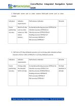
Cost-effective Integrated Navigation System GI320 3. Multi-path scenes such as urban canyons Multi-path scenes such as urban canyons Indicators Performance indicators requirements Fusion Multi-trail sites Horizontal positioning accuracy CEP95≤0.2m Pitch accuracy CEP95≤0.1° Roll accuracy CEP95≤0.1° 4. Half-sky to 2/3-day sheltered scenarios such as driving under elevated surfaces Scenario criteria: 4.5km at 40km/h in a 2/3 day sheltered scenario Indicators Performance indicators requirements Fusion Driving under Horizontal positioning accuracy CEP95≤2.5m Heading accuracy CEP95≤0.2° Pitch...
Open the catalog to page 9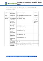
Cost-effective Integrated Navigation System GI320 5. Long-distance scenarios with full obscuration such as along tunnels (no RTK, complete loss of signal) Indicators Performance indicators requirements Fusion Pure inertial guidance projection progress scenarios with full obscuration Error less than 0.2%, 2σ loss of signal) Out-of-lock horizontal position drift Out-of-lock elevation position drift Out-of-lock heading drift Out-of-lock cross roll pitch drift Exit tunnel INS recovery time Trajectory ≤10s,3σ No jump points, no abrupt speed changes Bewis Sensing Technology LLC www.bwsensing
Open the catalog to page 10
Cost-effective Integrated Navigation System GI320 Command configuration Annex 1: Configuration instructions Bewis sensor high-precision integrated navigation input command supports simplified ASCII format. The simplified ASCII format without parity digit is more convenient for user's command input. All commands consist of a command header and configuration parameters (the parameter part can be empty, then the command has only one command header), and the header field contains the command name or message header. Common commands are shown in the following table: Command config 115200...
Open the catalog to page 11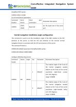
Cost-effective Integrated Navigation System GI320 Simplified ASCII syntax: CONFIG COM1 115200 List of serial device parameters Command Set the baud rate of the serial Baud rate Parameter Description Inertial navigation installation angle configuration This command is used to set the installation angle of the IMU relative to the XYZ direction of the carrier, so that the XYZ axis direction of the receiver inertial navigation device is consistent with the XYZ axis direction of the carrier. The command format is: CONFIG INS ANGLE [parameter] Simplified ASCII syntax: CONFIG INS ANGLE 0 9000...
Open the catalog to page 12
Cost-effective Integrated Navigation System GI320 The rotation angle of the inertial navigation module Z-axis relative 3 to the carrier coordinate Z-axis (right-handed helix); unit: 0.01 degrees; range: 0-36000 IMU to main antenna mast arm parameter configuration Use this command to enter the offset between the IMU and the GNSS main antenna phase center, the inertial to main antenna mast arm parameter. When measuring lever arm parameters, it should be as accurate as possible, especially in RTK mode, the error is preferably within 1mm. Any errors in the lever arm parameters will translate...
Open the catalog to page 13All Wuxi Bewis Sensing Tecnology LLC catalogs and technical brochures
-
BWSENSING BWK217S
8 Pages
-
AH100C
9 Pages
-
LoRaWAN G500 Gateway
1 Pages
-
LoRaWAN G200 Gateway
1 Pages
-
BWSENSING BWS5000E
14 Pages
-
BWSENSING Catalog 2020
60 Pages
-
BWSENSING BWK228
13 Pages
-
BWSENSING BWK218
12 Pages
-
BWSENSING BWK220
13 Pages
-
BWSENSING BWK210
13 Pages
-
BWSENSING BWK227S
13 Pages
-
BWSENSING BWK226S
13 Pages
-
BWSENSING BWK225S
12 Pages
-
BWSENSING BWK216S
12 Pages
-
BWSENSING BWK215S
12 Pages
-
BWSENSING BWL320
13 Pages
-
BWSENSING BWL328
13 Pages
-
BWSENSING BWL318
12 Pages
-
BWSENSING BWL310
13 Pages
-
BWSENSING BWL327S
13 Pages
-
BWSENSING BWL326S
13 Pages
-
BWSENSING BWL325S
12 Pages
-
BWSENSING BWL317S
12 Pages
-
BWSENSING BWL316S
12 Pages
-
BWSENSING BWL315S
12 Pages
-
BWSENSING BWN460
12 Pages
-
BWSENSING BWN428
13 Pages
-
BWSENSING BWN427
13 Pages
-
BWSENSING BWN425
12 Pages
-
BWSENSING BWN420
13 Pages
-
BWSENSING BWM460
12 Pages
-
BWSENSING BWM427
13 Pages
-
BWSENSING BWM426
13 Pages
-
BWSENSING BWM425
12 Pages
-
BWSENSING BWM420
13 Pages
-
BWSENSING BWM418
12 Pages
-
BWSENSING BWM417H
12 Pages
-
BWSENSING BWM417
12 Pages
-
BWSENSING BWM416
12 Pages
-
BWSENSING BWM415
12 Pages
-
BWSENSING BWM410
12 Pages
-
BWSENSING BWH528
14 Pages
-
BWSENSING BWH527
13 Pages
-
BWSENSING BWH526
14 Pages
-
BWSENSING BWH525
12 Pages
-
BWSENSING BWH520
14 Pages
-
BWSENSING BWH518
13 Pages
-
BWSENSING BWH517
12 Pages
-
BWSENSING BWH516
13 Pages
-
BWSENSING BWH515
12 Pages
-
BWSENSING BWH510
13 Pages
-
BWSENSING BWS5500
12 Pages
-
BWSENSING BWS4800
14 Pages
-
BWSENSING BWS5700
13 Pages
-
BWSENSING BWS2500
12 Pages
Archived catalogs
-
BWSENSING BWN426
13 Pages

