Trimble VX
1 /4Pages

Trimble VX
1 /4Pages
Catalog excerpts
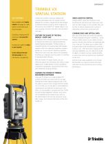
TRIMBLE VX spatial station Key Features Now available with Trimble VISION technology for video robotic control and scene documentation Surveying, imaging and 3D scanning in one powerful solution Increase your agility to adapt to any situation Create enhanced 2D and 3D deliverables for rich information management Capture and combine scanning, imaging and surveying deliverables with the singular solution designed for surveyors. Integrating the technologies of advanced optical surveying, metric imaging and 3D scanning, the Trimble® VX™ Spatial Station is the only surveying instrument that does it all and does it with ease. Video-Assisted Control Trimble VISION™ gives you the power to see everything the instrument sees. Direct your work with live video images on the controller. Now you are free to capture measurements to prism or reflectorless surface with a point and click. Combine GNSS and Optical Data Capture the shape of the real world – every day Expectations from surveying customers are evolving. To improve the efficiency of capturing advanced Spatial Imaging deliverables, Trimble provides an integrated solution for bringing these technologies together within the traditional workflows surveyors already use. So you have the flexibility to perform feature-rich scans every day, without the complexity of setting up a separate scanning system or switching to specialized field software. With the Trimble VX Spatial Station, you can efficiently capture the information you need to create digital terrain models (DTMs), volume calculations, and perform topographic measurements faster than with traditional surveying methods. Harness the Power of Trimble RealWorks software Advanced 3D models and image-rendered 3D surfaces are within your reach with the rich data delivered by Trimble Spatial Imaging sensors. With the ability to capture metric images with the Trimble VX in the field, you are also able to make additional measurements and attribute the data back in the office. It’s all accessible to surveyors with the Trimble VX and Trimble RealWorks® software. Your clients will immediately see the detail of your work via 3D walkthroughs of the job site using your survey data, images, and scanned information all from the Trimble VX. Take your productivity even further by adopting Trimble Integrated Surveying™ workflows – simply add your GNSS receiver to your robotic rod and powerful Trimble field software will seamlessly take care of the rest. This allows you to collect GNSS and optical data while simultaneously scanning a surface or site. With the built-in imaging and 3D scanning capabilities, you can capture the shape of objects of interest, such as a nearby building or power lines while you perform your traditional survey work. With the long range capabilities of the Trimble DR Plus EDM, you measure further with fewer instrument set-ups and enhance your scanning performance.
Open the catalog to page 1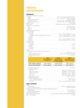
GEneral Specifications PERFORMANCE Scanning (not enabled on all models) Range1, 2 . . . . . . . . . . . . . . . . . . . . . . . . . . . . . . . . . . . . . . . . . . from 1 m up to 250 m (3.28 ft–820 ft) Speed3. . . . . . . . . . . . . . . . . . . . . . . . . . . . . . . . . . . . . . . . . . . . up to 15 points/sec, typical 5 points/sec Minimum point spacing. . . . . . . . . . . . . . . . . . . . . . . . . . . . . . . . . . . . . . . . . . . . . . . . 10 mm (0.032 ft) Standard deviation. . . . . . . . . . . . . . . . . . . . . . . . . . . . . . . . . . . 3 mm @ ≤150 m (0.0098 ft @ ≤492 ft) Single...
Open the catalog to page 2
GEneral Specifications System SPECIFICATIONS Leveling Circular level in tribrach. . . . . . . . . . . . . . . . . . . . . . . . . . . . . . . . . . . . . . . . . . . . . . . . . . . 8'/2 mm (8’/0.007 ft) Electronic 2-axis level in the LC-display with a resolution of 0.3" (0.1 mgon) Servo system . . . . . . . . . . . . . . . . . . . . . . . . . . . . . . . . . . . . . . . . . . . . . . . . . . MagDrive servo technology, integrated servo/angle sensor electromagnetic direct drive Rotation speed. . . . . . . . . . . . . . . . . . . . . . . . . . . . . . . . . . . . . . . . . . . . . . . 115 degrees/sec...
Open the catalog to page 3
Target color, atmospheric conditions, and scanning angles will impact range. Kodak Gray Card, Catalog number E1527795. Target shape, texture, and color; grid size; and distance and angle to target; will impact speed. Standard clear: No haze. Overcast or moderate sunlight with very light heat shimmer. Range and accuracy depend on atmospheric conditions, size of prisms and background radiation. Dependent on selected size of search window. 0.5 frames per second with remote operation. The capacity in –20 ºC (–5 ºF) is 75% of the capacity at +20 ºC (68 ºF). Bluetooth type approvals are country specific....
Open the catalog to page 4All Trimble catalogs and technical brochures
 TSC3
TSC32 Pages
 Trimble TDL 450
2 Pages
 Trimble R9s
2 Pages
 Trimble R10
4 Pages
 Trimble DiNi
2 Pages
 Trimble C5 & C5 HP
2 Pages
 Trimble TSC7
2 Pages
 Trimble SX10
4 Pages
 Trimble S5 Total Station
2 Pages
 Trimble Tablet Rugged PC
2 Pages
 Trimble TX8 Laser Scanner
2 Pages
 Nomad 900G Series Handhelds
2 Pages
 Yuma 2
2 Pages
 Ranger 3
2 Pages
 Juno T41
4 Pages
 Nomad 900 Series
2 Pages
 FARO Focus 3D X 130
2 Pages
 DIG DEEPER
12 Pages
 Trimble R10 GNSS system
2 Pages
 Marine Construction
4 Pages
 Site Positioning Systems
16 Pages
 Trimble GPS Systems
8 Pages


Archived catalogs
 Trimble tx5 scanner
2 Pages
 Trimble Geo 7X
2 Pages
 Juno 3 Series
2 Pages
 trimble R8 GNSS system
2 Pages
 TRIMBLE 450L AND 450H RADIOS
2 Pages
 Trimble M3
2 Pages


- Management software solution
- Automation software solution
- Analysis software solution
- Process software
- Real-time software
- Computer-aided design software
- Cloud-based software
- Control software
- Touch screen tablet
- Wireless tablet
- Rugged tablet
- 3D software solution
- Interface software
- Bluetooth tablet
- WiFi tablet
- Quality software
- Visualization software solution
- GNSS tablet
- Automated software
- Development software