Trimble Spatial Imaging Brochure - English
1 /8Pages

Trimble Spatial Imaging Brochure - English
1 /8Pages
Catalog excerpts

The last decade has seen tremendous growth in the geospatial industry. Geospatial imaging applications now play a key role in mainstream business and consumer applications. And those applications demand expanded functionality including imaging and measurement captured from the ground.While geospatial imaging captures data from overhead using airborne or satellite sensors, spatial imaging provides views and positioning measurements captured at eye-level. Spatial Imaging extends the functionality of geospatial information and opens the door to powerful new applications and opportunities. > Trimbles...
Open the catalog to page 2
Trimbles Spatial Imaging sensors, the Trimble GX Taking advantage of the detailed data provided by Trimble Spatial Imaging sensors, Trimble RealWorks Survey Because a picture is worth a thousand words, the recipients of visual data produced via a Trimble Spatial Imaging solutionҗwhether colleague or clientcan easily see what the data represents. Information can be shared directly or exported to CAD software for extensive analysis and integration into design specifications.With such powerful deliverables, the review and approval of jobs is more streamlined, as is decision-making. > י 3D Scanner...
Open the catalog to page 3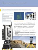
Trimble Spatial Imaging sensors are field-ready instruments designed to capture highly accurate terrestrial data. Rich collections of geospatial information allow users to identify areas of interest and extract exactly the information they need. Capture comprehensive imaging and positioning data using one integrated sensor.Extract the relevant details of complex scenes quickly and easily.Enhance 3D visualizations with color, attribute detail and survey-accurate positioning.Communicate compelling resultsfrom RealWorks Survey software via video generation or export to Google Earth (kml format)....
Open the catalog to page 4
Capable of photo-realistic resolution, the Trimble GX 3D Scanner delivers the ultimate in Spatial Imaging detail. Data can be captured at the sub-centimeter level, giving you clear visibility into every nuance of a scene. Unsurpassed in applications such as monitoring the evolution of a work site, as-built diagnostics, historic restorations, and crime scene forensics, the Trimble GX provides the highest resolution of any scanner on the market today. > technology boosts data acquisition range up to 350 m when range is a priority.ٕ Millions of points can be measured at high resolution and unequalled...
Open the catalog to page 5
With Trimble Spatial Imaging, you can create a virtual world that represents the work in which you and your clients are involved. Trimble RealWorks Survey enables you to capture, extract and analyze as-built scenes to create compelling 2D and 3D deliverables for immediate output or export. TRIMBLE REALWORKS SURVEY SOFTWARE Spatial imaging creates new demands for the management and analysis of data. A single scan can capture literally millions of data points, which then need to be converted into a usable form. Trimble RealWorks Survey is the central information processing application of Trimble...
Open the catalog to page 6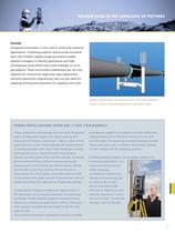
UTILITIES Geospatial information is now vital in utility and industrial applications. Combining airborne and accurate terrestrial data with Trimble's Spatial Imaging solutions enable pipeline managers to identify geohazards and High Consequence Areas (HCA) that could endanger an oil or gas pipeline. These environment assessments are not only required for construction approvals, pipe replacement and pre-construction engineering; they are also ideal for assessing shifting and movement of a pipeline over time. > Pipeline modeling based on measured points. Put Trimble RealWorks Survey to work in...
Open the catalog to page 7All Trimble catalogs and technical brochures
 TSC3
TSC32 Pages
 Trimble TDL 450
2 Pages
 Trimble R9s
2 Pages
 Trimble R10
4 Pages
 Trimble DiNi
2 Pages
 Trimble C5 & C5 HP
2 Pages
 Trimble TSC7
2 Pages
 Trimble SX10
4 Pages
 Trimble S5 Total Station
2 Pages
 Trimble Tablet Rugged PC
2 Pages
 Trimble TX8 Laser Scanner
2 Pages
 Nomad 900G Series Handhelds
2 Pages
 Yuma 2
2 Pages
 Ranger 3
2 Pages
 Juno T41
4 Pages
 Nomad 900 Series
2 Pages
 FARO Focus 3D X 130
2 Pages
 DIG DEEPER
12 Pages
 Trimble VX
4 Pages
 Trimble R10 GNSS system
2 Pages
 Marine Construction
4 Pages
 Site Positioning Systems
16 Pages
 Trimble GPS Systems
8 Pages


Archived catalogs
 Trimble tx5 scanner
2 Pages
 Trimble Geo 7X
2 Pages
 Juno 3 Series
2 Pages
 trimble R8 GNSS system
2 Pages
 TRIMBLE 450L AND 450H RADIOS
2 Pages
 Trimble M3
2 Pages


- Management software solution
- Automation software solution
- Analysis software solution
- Process software
- Real-time software
- Cloud-based software
- Control software
- Touch screen tablet
- Wireless tablet
- Rugged tablet
- 3D software solution
- Interface software
- Bluetooth tablet
- WiFi tablet
- Quality software
- Visualization software solution
- GNSS tablet
- Automated software
- Development software