


Site Positioning Systems

Site Positioning Systems
Trimble Site Positioning Systems are designed to enhance jobsite efficiency, reduce errors, and lower material costs by facilitating measurement, staking, checking, management, and inspection. These systems ensure seamless data movement between the office, machines, and site personnel.
- Field Software: Trimble SCS900 and SCS700 provide user-friendly interfaces to boost efficiency and productivity across various site roles.
- GNSS Receivers: These are scalable to meet accuracy and budget requirements, suitable for both rover and vehicle configurations.
- Total Stations: Offer high accuracy for site positioning, stakeout, and machine control.
- Office Software: Business Center – HCE supports data-related activities from estimation to paving.
- Connected Controller: Ensures data synchronization between the field and office, minimizing rework and miscommunication.
- Trimble Site Tablet: A rugged field computer providing real-time data access and communication.
- Trimble TSC3: A durable handheld controller for GNSS or total station operations, ideal for outdoor construction environments.
- Tunneling: Efficiently meets measuring and positioning needs in tunneling projects.
- Roading: Supports road and highway projects with comprehensive alignment and staking solutions.
- Advanced Measurement: Captures additional data for informed decision-making and analysis.
- GNSS Receivers: Provide scalable precision, with high accuracy options for challenging conditions.
- Total Stations: Deliver high precision for smaller sites or when combined with GNSS on larger sites, suitable for high accuracy tasks.
- Connected Controller: Enables wireless data synchronization and GNSS corrections, boosting productivity.
- Connected Office: Facilitates 3D model creation, data preparation, and site productivity monitoring.
- Connected Machine: Standard in Trimble Grade Control Systems, it manages assets and enhances grading precision.
The Trimble Connected Site integrates Connected Office, Controller, and Machine solutions to transform construction efficiency, productivity, and sustainability, reducing waste and costs.
SITECH dealerships provide guidance on selecting appropriate technology for construction projects, along with local customer service, personalized training, and technical support, ensuring smooth implementation and ongoing assistance.
The document lists various Trimble equipment, including the SPS985 Precision Rover, TSC3, Trimble Site Tablet, and SPS930 Universal Total Station, highlighting their precision in both horizontal and vertical measurements.
The Trimble SPS930 Universal Total Station offers horizontal accuracy of 3mm and vertical accuracy of 1mm at 100 meters. Trimble GNSS systems provide real-time kinematic accuracy of 8mm horizontally and 15mm vertically, with similar precision for VRS systems.
A table recommends specific Trimble equipment for roles such as Site Surveyor, Site Engineer, and Project Manager, with alternative options also listed.
Trimble has a global presence with offices in North America, Europe, Africa & Middle East, Asia-Pacific, and China, providing contact information for each region.
Trimble positions itself as a leader in construction technology, offering tools and support to integrate various aspects of construction projects, leading to more efficient operations and higher profitability.
Catalog excerpts

EASY-TO-USE RELIABLE ACCURATE Trimble Site Positioning Systems
Open the catalog to page 1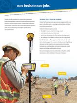
more tools for more jobs neer • Construction ager • Geotechnical Engi upervisor • Project Man ecker • Site Foreman/S gineer/Grade Ch a Manager • Site En • Site Surveyor • Dat timators • Bid Team • Es Trimble sets the standard for construction technology by developing highly productive, integrated and innovative solutions for the complete jobsite. Trimble Site Positioning Systems help contractors take control of the jobsite, perform tasks more productively, meet tighter specifications, and avoid rework. Inspector • The Right Tools to do the Job Right. Trimble® Site Positioning Systems give contractors...
Open the catalog to page 2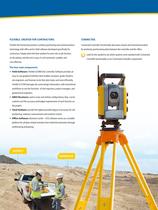
Flexible. Created for Contractors. CONNECTED. Trimble Site Positioning Systems combine positioning and communications Connected Controller functionality decreases rework and miscommunication technology with office and in-field software developed specifically for by wirelessly synchronizing data between the controller and the office. contractors. Simply select the best solution for each role or job function Look for this symbol to see which systems come standard with Connected on the jobsite, and the rest is easy. It is all connected, scalable, and Controller functionality or are Connected Controller...
Open the catalog to page 3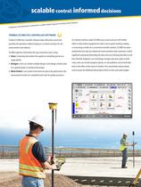
scalable control: informed decisions Tunneling • Rail • ll • Waste Disposal • Earthworks • Landfi Site Preparation • • Highways • Mining • Trimble SCS900 Site Controller Software Trimble SCS900 Site Controller Software helps efficiently control and An intuitive interface makes SCS900 easy to learn and use with Trimble quantify site operations without relying on a contract surveyor for site GNSS or total station equipment for tasks such as grade checking, staking measurement and stakeout. or measuring as-builts. As a connected controller solution, SCS900 increases SCS900 organizes information...
Open the catalog to page 4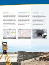
The Trimble SCS900 Roading Module supports road and highway projects by incorporating full alignment geometry, station equations, width transitions and multiple roadways within a selected job. It is a single solution to all road staking needs - from roadway features to catch points to custom subgrades. In addition, grade checking functions allow contractors to easily perform as-built checks and quality control. Module improves informed decision-making by capturing additional information with each measured point; for example, photos, dimensions, conditions and material type add more valuable information...
Open the catalog to page 5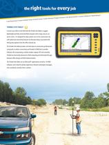
the right tools for every job a g • Control and B • Site Positionin se Setup • As-buil t Survey • Grade C Volumes • Site Me hecking • Progress trimble SITE tablet Connect your office to the field with the Trimble Site Tablet, a rugged, lightweight and fully connected field computer with a large, easy to use touch screen. It is designed for daily outdoor use on the construction site with advanced connectivity features to eliminate delays associated with driving data updates from the office and job site. The Trimble Site Tablet provides real-time data to construction professionals using built-in...
Open the catalog to page 6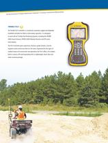
Site Reconnaissance • Prog ress Monitoring • Inspection • Locating • Geotechnical Measure trimble TSC3 The Trimble TSC3 controller is a wirelessly connected, rugged and adaptable handheld controller for GNSS or total station operation. It is designed to work with all Trimble Site Positioning Systems, including the SPS985 GNSS Smart Antenna, SPS855 GNSS Modular Receiver and SPS series total stations. The TSC3 controller gives supervisors, foremen, grade checkers, and site engineers total control over their on-site tasks. Engineered for the rigors of outdoor heavy civil construction site operations,...
Open the catalog to page 7
GNSS: scalable, reliable precision TRIMBLE GNSS RECEIVERS Outstanding Flexibility Base Stations and Accuracy Ideal for: Trimble Site Positioning receivers are scalable to Because the atmosphere distorts satellite signals, • Larger jobsites meet the accuracy requirements of specific tasks high accuracy GNSS positioning requires a base • Tasks where accuracy requirements and fit your budget. Trimble offers GNSS (Global station receiver and a rover receiver, both of Navigation Satellite System) receivers both in which receive the same satellite signals at the integrated and modular forms. With integrated...
Open the catalog to page 8
GNSS ACCURACY Trimble system modularity lets you select the accuracy level you need for the job: • Precision GNSS Receivers can provide accuracies of 8 millimeters horizontal (0.03 feet) and 15 millimeters (0.05 feet) vertical • Location GNSS Receivers can provide accuracies of 100 millimeters (0.3 feet) horizontal and 20-100 millimeters (0.06 to 0.3 feet) vertical • Integrated GPS in the Trimble Site Tablet, TSC3, and TCA1 controller deliver multi-meter level accuracy Smart Antenna: The ultra-rugged SPS985 GNSS Smart Antenna provides everything you need in one compact unit: GNSS receiver, wireless...
Open the catalog to page 9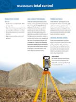
total stations: total control TRIMBLE TOTAL STATIONS High Accuracy Performance TRIMBLE MULTITRACK Ideal for: Trimble Site Positioning Total Stations provide Trimble MultiTrack™ technology locks on and • Smaller sites or combined with GNSS very high accuracy, high performance one-person tracks prisms for stakeout, measurement, grade 3D positioning. Trimble SPS930, SPS730 and control and monitoring applications. Active • Tasks where the accuracy requirements SPS630 Universal Total Stations provide the targets provide enhanced tracking performance are very tight: 3 millimeter (0.01 feet) greatest...
Open the catalog to page 10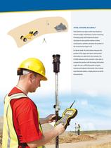
TOTAL STATIONS ACCURACY Total Stations use optics and/or laser beams to measure angles and distances. By first measuring to known points, the Trimble total station calculates its own position relative to these control points, and then calculates the position of the measurement target in 3D. In robotic mode, the total station measures the position of the target and reports that position information via radio link to the controller. The SCS900 software on the controller is then able to compare the position with the design information to give the user cut/fill information, progress volumes and stakeout...
Open the catalog to page 11All Trimble catalogs and technical brochures
 TSC3
TSC32 Pages
 Trimble TDL 450
2 Pages
 Trimble R9s
2 Pages
 Trimble R10
4 Pages
 Trimble DiNi
2 Pages
 Trimble C5 & C5 HP
2 Pages
 Trimble TSC7
2 Pages
 Trimble SX10
4 Pages
 Trimble S5 Total Station
2 Pages
 Trimble Tablet Rugged PC
2 Pages
 Trimble TX8 Laser Scanner
2 Pages
 Nomad 900G Series Handhelds
2 Pages
 Yuma 2
2 Pages
 Ranger 3
2 Pages
 Juno T41
4 Pages
 Nomad 900 Series
2 Pages
 FARO Focus 3D X 130
2 Pages
 DIG DEEPER
12 Pages
 Trimble VX
4 Pages
 Trimble R10 GNSS system
2 Pages
 Marine Construction
4 Pages
 Trimble GPS Systems
8 Pages


Archived catalogs
 Trimble tx5 scanner
2 Pages
 Trimble Geo 7X
2 Pages
 Juno 3 Series
2 Pages
 trimble R8 GNSS system
2 Pages
 TRIMBLE 450L AND 450H RADIOS
2 Pages
 Trimble M3
2 Pages


- Management software solution
- Automation software solution
- Analysis software solution
- Process software
- Real-time software
- Computer-aided design software
- Cloud-based software
- Control software
- Touch screen tablet
- Wireless tablet
- Rugged tablet
- 3D software solution
- Interface software
- Bluetooth tablet
- WiFi tablet
- Visualization software solution
- Quality software
- GNSS tablet
- Automated software
- Windows tablet