GMS-2Pro
1 /4Pages

GMS-2Pro
1 /4Pages
Catalog excerpts
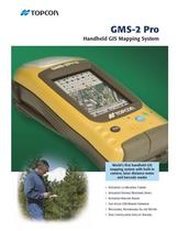
Field Software Solutions No mapping solution is satisfactory unless the software is easy to use and learn. Topcon offers a variety of software solutions and as well as partner solutions for the GMS-2 family of products. Whether it’s an existing sophisticated ESRI ArcPad® customization or a deployment of many novice users into the eld, Topcon has a software solution to suit. Field Tools for ArcPad® is an extension for ESRI’s ArcPad® mobile GIS software, allowing a user to take full advantage of the GMS-2 Pro’s integrated camera, compass, laser distance meter, and barcode reader. Other primary features include: • Informative, graphical GPS Status screen displaying GPS and Glonass satellites • High accuracy mapping using real-time and post-processing techniques • Log raw data for post-processing • Work in native shapele formats • Geotagged images Topcon software also provides the exibility to connect to high accuracy survey grade receivers for cm-level results in real-time. This provides a complete solution for GIS users who have high accuracy database requirements. Keeping a GIS database up-to-date can be a challenge. GIS departments must gure out a way to do more with less people and less funding. With the Topcon GMS-2 Pro, accurate data can be mapped in less time with less effort. Tracking both the US GPS and the GLONASS satellite constellations means less down time in the eld. Easy-to-use software allows for deployment of multiple users in the eld. The integrated digital camera and laser distance meter means eld personnel will return to the ofce safely with more detailed information than ever before. This little GMS-2 Pro is the simple answer to some of your biggest GIS data collection and maintenance challenges. Specications Number of Channels DGPS Accuracy L1 Static Function L1 PP Kinematic Function WAAS/EGNOS CORS Beacon Internal Memory Interface USB Card Slot GNSS Receiver Processor/Operating System Onboard Software Ofce Software (post processing) Display Laser Distance Meter Built-in Camera Keyboard Magnetic Compass Input/Output Battery Life Battery Type Dimensions Weight Environmental 50 <1m* H: RMS 3mm + 0.8ppm V: RMS 4mm + 1.0ppm H: RMS 10mm + 1.0ppm V: RMS 15mm + 1.0ppm Yes Yes with BR-1 SDRAM 128MB Flash 256MB NAND * < 50cm with external PG-A5 antenna The Leader in Positioning Technology... Topcon Positioning Systems is the worldwide leading developer and manufacturer of precision positioning equipment and offers the widest selection of innovative precision GPS systems, laser, optical surveying, and machine control products. From open-eld construction projects to isolated surveying sites and from rolling farmland to inner city utility projects, Topcon Positioning Systems creates innovative technology solutions that give a decidedly competitive edge to end-users. Topcon Positioning Systems, Inc. Your local Authorized Topcon dealer is: P/N: 7010-2007 Rev. B World’s first handheld GIS mapping system with built-in camera, laser distance meter and barcode reader • Integrated 2.0 Megapixel Camera • Integrated Distance Measuring Device • Integrated Barcode Reader • Easy Access USB Memory Expansion • Replaceable, Rechargeable All-day Battery Specifications subject to change without notice ©2008 Topcon Corporation Handheld GIS Mapping System Mini Port SD GPS + GLONASS 520 MHz Intel PXA270 Microsoft Windows® CE 5.0 Field Tools for ArcPad® Topcon Tools GIS 3.5” 240 x 320 color QVGA w/ touch screen .22 to 50m, +/-5mm m.s.e 2.0 Megapixel, Barcode Reader 3 Key plus Virtual Keyboard +/– 4 degrees (in level after calibration) Bluetooth, USB, Serial, ANT, and Power 7 hrs while in GPS mode 2500mAh Removable, Li-Ion Rechargeable H: 8.27” W: 3.7” D: 3.07” (210 x 94 x 78mm) 0.9kg (1.98lb) IP66, 1 meter drop -20° to 50°C Operating Temperature -10° to 50°C Operating with camera -30° to 60°C Storage Temperature Recognized as the innovative trend-setter in its industry, Topcon has focused on developing an array of integrated positioning and automation technologies to meet the constantly changing demands facing GIS, construction, surveying, agriculture, utilities and law enforcement professionals worldwide. We look forward to building solutions that solve your data collection project challenges today and in the future. 7400 National Drive Livermore, CA 94550 www.topconpositioning.com GMS-2 Pro All rights reserved. • Dual Constellation Satellite Tracking Printed in U.S.A. 12/08 ESRI, ArcPad are registered trademarks of ESRI in the United States, the European Community, or certain other jurisdictions. Other trademarks and trade names are those of their respective owners.
Open the catalog to page 1
Collecting, storing, and accessing accurate information in a GIS database has long been a priority for GIS practitioners A revolutionary all-in-one device for accurate, fast and safe GIS eld mapping. The GMS-2 Pro brings to reality what was once just a dream of incorporating more functionality into one handheld device than ever thought possible! in fields such as environmental management, utility infrastructure mapping, forestry, archeology, emergency management, and more. A new mapping solution exists making this process easier for a single user or for safely deploying multiple users within...
Open the catalog to page 2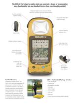
Collecting, storing, and accessing accurate information in a GIS database has long been a priority for GIS practitioners A revolutionary all-in-one device for accurate, fast and safe GIS eld mapping. The GMS-2 Pro brings to reality what was once just a dream of incorporating more functionality into one handheld device than ever thought possible! in fields such as environmental management, utility infrastructure mapping, forestry, archeology, emergency management, and more. A new mapping solution exists making this process easier for a single user or for safely deploying multiple users within...
Open the catalog to page 3All TOPCON catalogs and technical brochures
 RL-H5A
2 Pages
 GTL-1000
4 Pages
 CR-G5-C
1 Page
 GM-50
GM-502 Pages
 PG-S1
PG-S11 Page
 G5-A1
G5-A11 Page
 HiPer VR
4 Pages
 HiPer HR
4 Pages
 TP-L4 series
2 Pages
 DS series
4 Pages
 AT-B series
2 Pages
 Net-G5
1 Page
 Corporate Profile 2015
16 Pages
 Tesla
Tesla4 Pages
 IP-S3 HD1
4 Pages
 ScanMaster
2 Pages
 IP-S2 Lite
4 Pages
 GPT-3500LN / LNW
2 Pages
 NET-G3A Catalogue
2 Pages
 SRL-35 Catalogue
2 Pages
 CR-G5 Catalogue
2 Pages
 PN-A5 Catalogue
2 Pages
 LN-100 Catalogue
4 Pages
 MS05AXII / MS1AXII Catalogue
4 Pages
 MS Series Catalogue
2 Pages
 GTS-250 Series Catalogue
4 Pages
 GLS-2000
8 Pages
 SiteHunter Catalogue
4 Pages
 MAGNET Enterprise Catalogue
9 Pages
 LS-B10/B10W Catalogue
2 Pages
 AT-B Series Catalogue
2 Pages
 DT-200/200L Catalogue
4 Pages
 SRL-35 Heavy-Duty UHF Radio
2 Pages
 TSshield
2 Pages
 LS-B10/RD-10W SERIES
2 Pages
 FC-250 field controller
1 Page
 DS Direct aiming Station
4 Pages
 hiper pro
2 Pages
 ScsnMaster CAD Link
2 Pages
 TG-3
TG-32 Pages
 Euro 112T
2 Pages
 G3 160T
2 Pages
 HiPer Ga/Gb
2 Pages
 GLS-1500
8 Pages
 ES Catalogue
4 Pages
 OS Catalogue
4 Pages
 PS Series
4 Pages
 IS Catalogue
4 Pages
 GB-1000/500
2 Pages
 GRS-1
GRS-14 Pages
 Hyper II
2 Pages
 3D Laser Scanner GLS-1500
4 Pages
 Slope Lasers RL-100 1S/2S
2 Pages
 TP-L4 series PIPE LASER
2 Pages


Archived catalogs
 FC-2000 DATA COLLECTOR
2 Pages
 AT-G series AUTO LEVEL
2 Pages


- Management software solution
- Automation software solution
- Analysis software solution
- Measuring machine
- Windows software
- Computer-aided design software
- Cloud-based software
- Design software solution
- 3D software solution
- Interface software
- Measurement software
- Development software
- Creation software
- 2D software
- Modeling software
- 3D scanning system
- GNSS antenna
- Radio receiver
- Measurement scanner
- Laser scanner