


GLS-1500

GLS-1500
- Scanning range up to 500 meters.
- High-speed scanning at 30,000 points per second.
- Distance accuracy of 4mm at 150 meters.
- Includes a built-in digital camera for photo-realistic point clouds.
- Comes with ScanMaster software for data processing and 3D modeling.
- Utilizes Topcon Precise Scan Technology for ultra-low-noise and high-precision data.
- Remote control via wireless LAN for ease of use.
- Quick sighting with jog dial controls and a tilting range of ±90°.
- Road surface profiling for maintenance and repair planning.
- Volume measurement for land preparation and mining.
- Monitoring of large structures like bridges and dams.
- Disaster and accident scene surveying for simulation and analysis.
- Historical architecture preservation through detailed 3D modeling.
- Integration of Time of Flight and Phase Shift methods for enhanced accuracy.
- Selectable range modes for different scanning needs.
- Significant noise reduction for clearer data representation.
- Operating temperature range from 0°C to +40°C.
- IP52 dust and water protection.
- Dimensions: 240 x 240 x 566 mm; Weight: 16kg (excluding battery and tribrach).
- ScanMaster Field: Free tablet PC software for controlling the GLS series scanners.
- ScanMaster Office: Provides powerful data processing for CAD applications.
- ScanMaster Viewer: Enables data viewing and capturing for client presentations.
- Additional software from partners like kubit, Rapidform, and Pointools for specialized functions.
Catalog excerpts
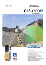
GLS-1500 Standard Configuration • • • • • • • • • • • • • • • • • • GLS-1500 scanner unit Target sheet (medium) Magnet target (small) Magnet target (medium) Adhesive target (small) x 5 Adhesive target (medium) x 10 BT-65Q battery x 4 BC-30D dual-battery charger x 2 (with AD-14 AC adapter x 2) Tribrach with optical plummet Wireless LAN card Head cover SD memory card (1GB) Tools Silicone cloth USB cable User manual Warranty certificate Carrying case Optional Accessories Tilting base Tilts the GLS-1500 unit to scan upper and lower portions of tunnels, buildings and other large structures. Maximum ±90° tilting range with 15° steps. SCANNING UNIT Maximum range 90% reflectivity 18% reflectivity Minimum range Single point accuracy Distance (at 1 to 150m) Angle (H&V) Surface accuracy (at 1 to 150m) Target detection accuracy Scan rate (maximum) Scan resolution Spot size Sample density (maximum) Field of view (per scan) Horizontal Vertical Laser Type Wavelength Laser class DIGITAL CAMERA Field of view Number of pixels TILT COMPENSATOR Type Compensation range DISPLAY Type INTERFACE Memory Wireless LAN USB POWER SUPPLY Removable battery (BT-65Q) Operating time Input voltage ENVIRONMENTAL Operating temperature Storage temperature Dust and water protection PHYSICAL Dimensions w/handle Instrument height Weight GEODETIC 3D LASER SCANNER Normal mode: 330m Long mode: 500m Normal mode: 150m Long mode: 230m 1m GLS-1500 3D Laser Scanner Normal mode: 4mm Long mode: 7mm 6" Normal mode: 2mm Long mode: 3mm 3" at 50m (164ft.) 30,000 points/second <6mm at 1 to 40m 1mm at 20m 360° (maximum) ±35° (maximum) Pulsed (time of flight) 1535nm (invisible, eye-safe) Class 1 Approx. 22° (V) x 16.5° (H) 2 megapixels Dual-axis tilt sensor ±6' LCD with backlight, 20 characters x 4 lines SD and SDHC memory cards IEEE 802.11b Type mini B Rev. 2.0 5Ah, 7.4V 4 hours per 4 removable batteries 12V DC 0°C to +40°C -10°C to +60°C IP52 (IEC 60529) High-Speed, Long-Range, High-Precision, All-in-One 3D Laser Scanner 240 (D) x 240 (W) x 566 (H) mm 410mm 16kg (excluding battery and tribrach) TOPCON CORPORATION Class 1 75-1 Hasunuma-cho, Itabashi-ku, Tokyo 174-8580, Japan Phone: (+81)3-3558-2993 Fax: (+81)3-3960-4214 www.topcon.co.jp Your local Authorized Topcon Dealer is: Specifications subject to change without notice ©2010-2011 Topcon Corporation All rights reserved. P-63-3 GLS-1500 GLS-1500 SPECIFICATIONS • Long-Range 500m • High-Speed Scan with 30,000 points/second • Topcon Precise Scan Technology Provides Clean, Ultra-Low-Noise Scan Data • 4mm Distance Accuracy at 150m • All-in-One Solution for Superior Mobility • Quick Sighting with Jog Dial Controls • Built-in Digital Camera • ScanMaster Software for Powerful Data Processing • Presents Photo-realistic Point Clouds • Remote Control via Wireless LAN
Open the catalog to page 1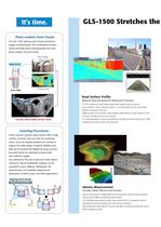
GLS-1500 Stretches the Boundaries of Your Survey Technology Photo-realistic Point Clouds The GLS-1500 captures point clouds and picture images simultaneously. The combination of point clouds and RGB picture data generates full-color, photo-realistic 3D point clouds. Picture Images Digital Camera Large Structure Laser 3D Point Clouds GLS-1500 Road Surface Profile Tunnel Monitoring of Critical Infrastructures such as Bridges, Towers, and Dams Scan data of large structures allow for early detection of deteriorated areas to be maintained or reinforced. 3D data can be utilized for measurements of...
Open the catalog to page 2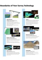
GLS-1500 Stretches the Boundaries of Your Survey Technology Photo-realistic Point Clouds The GLS-1500 captures point clouds and picture images simultaneously. The combination of point clouds and RGB picture data generates full-color, photo-realistic 3D point clouds. Picture Images Digital Camera Large Structure Laser 3D Point Clouds GLS-1500 Road Surface Profile Tunnel Monitoring of Critical Infrastructures such as Bridges, Towers, and Dams Scan data of large structures allow for early detection of deteriorated areas to be maintained or reinforced. 3D data can be utilized for measurements of...
Open the catalog to page 3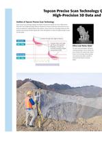
Topcon Precise Scan Technology Quickly Acquires Ultra-Low-Noise, High-Precision 3D Data and 500m Long-Range scanning! Selectable two-range mode Enable to select from 2 range mode, maximum 500m range mode is prepared in addition to existing 330m high-accuracy scanning. Calculates the high order digits of distance Returned pulse SAW - Filter Calculates lower order digits with Phase Shift algorithm. Reliability is increased by constantly averaging multiple measurement results. Range Accuracy GLS-1500 Long Range Mode Total Total Noise Noise Start pulse SAW - Filter Range Accuracy GLS-1500 Normal...
Open the catalog to page 4
Topcon Precise Scan Technology Quickly Acquires Ultra-Low-Noise, High-Precision 3D Data and 500m Long-Range scanning! Selectable two-range mode Enable to select from 2 range mode, maximum 500m range mode is prepared in addition to existing 330m high-accuracy scanning. Calculates the high order digits of distance Returned pulse SAW - Filter Calculates lower order digits with Phase Shift algorithm. Reliability is increased by constantly averaging multiple measurement results. Range Accuracy GLS-1500 Long Range Mode Total Total Noise Noise Start pulse SAW - Filter Range Accuracy GLS-1500 Normal...
Open the catalog to page 5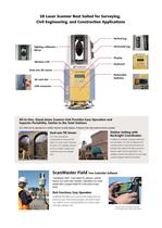
3D Laser Scanner Best Suited for Surveying, Civil Engineering, and Construction Applications ScanMaster Office Software Bridging Scan Data and CAD ScanMaster software provides exceptional processing power to prepare 3D data for CAD applications. Featuring an array of automated functions and instrument control capability, ScanMaster dramatically increases both office and field work efficiency. Vertical jog Horizontal jog Sighting collimator / Mirror Display Wireless LAN Cut/fill volume using design plane Keyboard Volume regions Automated Tie-Point Registration Removable batteries SD card slot...
Open the catalog to page 6All TOPCON catalogs and technical brochures
 RL-H5A
2 Pages
 GTL-1000
4 Pages
 CR-G5-C
1 Page
 GM-50
GM-502 Pages
 PG-S1
PG-S11 Page
 G5-A1
G5-A11 Page
 HiPer VR
4 Pages
 HiPer HR
4 Pages
 TP-L4 series
2 Pages
 DS series
4 Pages
 AT-B series
2 Pages
 Net-G5
1 Page
 Corporate Profile 2015
16 Pages
 Tesla
Tesla4 Pages
 IP-S3 HD1
4 Pages
 ScanMaster
2 Pages
 IP-S2 Lite
4 Pages
 GPT-3500LN / LNW
2 Pages
 NET-G3A Catalogue
2 Pages
 SRL-35 Catalogue
2 Pages
 CR-G5 Catalogue
2 Pages
 PN-A5 Catalogue
2 Pages
 LN-100 Catalogue
4 Pages
 MS05AXII / MS1AXII Catalogue
4 Pages
 MS Series Catalogue
2 Pages
 GTS-250 Series Catalogue
4 Pages
 GLS-2000
8 Pages
 SiteHunter Catalogue
4 Pages
 MAGNET Enterprise Catalogue
9 Pages
 LS-B10/B10W Catalogue
2 Pages
 AT-B Series Catalogue
2 Pages
 DT-200/200L Catalogue
4 Pages
 SRL-35 Heavy-Duty UHF Radio
2 Pages
 TSshield
2 Pages
 LS-B10/RD-10W SERIES
2 Pages
 FC-250 field controller
1 Page
 DS Direct aiming Station
4 Pages
 hiper pro
2 Pages
 ScsnMaster CAD Link
2 Pages
 TG-3
TG-32 Pages
 Euro 112T
2 Pages
 G3 160T
2 Pages
 HiPer Ga/Gb
2 Pages
 ES Catalogue
4 Pages
 OS Catalogue
4 Pages
 PS Series
4 Pages
 IS Catalogue
4 Pages
 GMS-2Pro
4 Pages
 GB-1000/500
2 Pages
 GRS-1
GRS-14 Pages
 Hyper II
2 Pages
 3D Laser Scanner GLS-1500
4 Pages
 Slope Lasers RL-100 1S/2S
2 Pages
 TP-L4 series PIPE LASER
2 Pages


Archived catalogs
 FC-2000 DATA COLLECTOR
2 Pages
 AT-G series AUTO LEVEL
2 Pages


- Automation software solution
- Management software solution
- Analysis software solution
- Measuring machine
- Windows software
- Computer-aided design software
- Cloud-based software
- Design software solution
- 3D software solution
- Measurement software
- Interface software
- Development software
- Creation software
- 2D software
- 3D scanning system
- Data acquisition software
- Modeling software
- Measurement scanner
- Radio receiver