Catalog excerpts

IP-S2 Compact+ 3D Mobile Mapping System • 3D scanning of road and roadside features • Delivers high density point clouds and 360° spherical imagery • High accuracy IMU options without export control • Simple Map, Extract, Deliver Workflow • Integrated, turn key solution
Open the catalog to page 1
IP-S2 Compact+ 3D Mobile Mapping System The IP-S2 Compact+ gives a high density point cloud with colorful image overlay for the ultimate in feature recognition and mapping detail. Laser Scanner • Captures high resolution, high density 3D point clouds • Standard 3 scanner or optional 5 scanner configuration for increased cloud density • Excellent precision at short range Topcon’s IP-S2 Compact+ Mobile Mapping System overcomes the challenges of mapping 3D features at a high level of accuracy. Accurate vehicle positions are obtained using three technologies: a dual frequency GNSS receiver...
Open the catalog to page 2
IP-S2 COMPACT + PROJECT WORKFLOW Drive vehicle through route Pull features from point cloud Export data to GIS or CAD The IP-S2 Compacts Software Provides User-friendly Data Collection and Processing Solutions IP-S2 Compact+ Dashboard-Data Collection Software: Spatial Collect The IP-S2 Compact+ Dashboard operates on a PC web browser. It allows the user to easily control and configure the IP-S2 Compact+ Box. It also controls field data capture, storage and display. Geoclean - Post Processing Software GNSS Post Processing Geoclean determines the vehicle positions by means of continuous...
Open the catalog to page 3
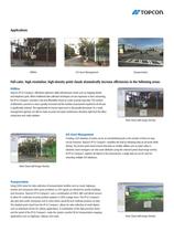
Applications Utilities GIS Asset Management Transportation Full-color, high-resolution, high-density point clouds dramatically increase efficiencies in the following areas: Utilities Topcon’s IP-S2 Compact+ effectively addresses utility infrastructure needs such as mapping electric and telephone grids. When traditional data collection techniques are too expensive or time consuming, the IP-S2 Compact+ provides a fast and affordable means to create accurate map data. The number of kilometres covered in a day is greatly increased and the number of personnel required to do the job is...
Open the catalog to page 4
SYSTEM OVERVIEW GNSS Antenna Panoramic Camera IP-S2 box with IMU Scanner 3-Scanner or 5-Scanner System Configuration The IP-S2 Compact + comes standard with 3 laser scanners oriented to optimize visibility of roadside assets for enhanced scanning detail. The standard scanner configuration gives a full 360° Vertical Field of View. The optional 5 scanner configuration increases the cloud density and minimizes scanning shades. The optional IP-S2 Compact+ 5 scanner system collects 150,000 points per second at a range of 40m, with a vertical field of view of 360°.
Open the catalog to page 5
IP-S2 Compact+ 3D Mobile Mapping System GNSS Component 40 channels, dual constellation, dual frequency Real Time Position & Raw Data U p to 10 Hz u pdate rate (Commercial Grade option. High accuracy IMU) Gyro type Fiber Optic Gyro Gyro Bias stability l°/hr Gyro Bias Offset 20°/hr Accelerometer Bias 7.5 mg (typical) (Tactical Grade option. High accuracy IMU*) Gyro type Gyro Bias stability Gyro Bias Offset Accelerometer Bias Input Supply Voltage System power consumption Ring Laser Gyro Panoramic Imagery Component Imaging Sensor Type Six (6) Sony progressive scan color CCDs (five in horizontal...
Open the catalog to page 6All TOPCON EUROPE POSITIONING catalogs and technical brochures
-
RL-SV2S
2 Pages
-
FC-6000
4 Pages
-
3D CONSTRUCTION
32 Pages
-
2D / 3D Excavator Control
2 Pages
-
IS-1 Series
9 Pages
-
FS-1 series
4 Pages
-
IMAGEnet i-base
2 Pages
-
OMS-800 Series
8 Pages
-
SP-1P
8 Pages
-
KR-1W
2 Pages
-
CA-800
16 Pages
-
SL-D Series
16 Pages
-
SL-2G
4 Pages
-
SL-D701
2 Pages
-
SL-D701
8 Pages
-
TRC-50DX
8 Pages
-
TRC-NW8 series
8 Pages
-
3D OCT
12 Pages
-
DRI OCT Triton series
20 Pages
-
GT SERIES
4 Pages
-
GR-5
4 Pages
-
3D-MC MAX
4 Pages
-
X-53
2 Pages
-
X-53i
2 Pages
-
DynaRoad
4 Pages
-
Topcon Tierra
4 Pages
-
DL series
4 Pages
-
Robotic Total Stations
4 Pages
-
Dozer GPS + Control
4 Pages
-
Dozer LPS control
4 Pages
-
MACHINE CONTROL CATALOGUE
16 Pages
-
Dozer Laser Control
4 Pages
-
LASER CATALOGUE
12 Pages
-
ScanMaster - Data Management
4 Pages
-
TopSURV7
4 Pages
-
Topcon Tesla RTK
4 Pages
-
IP-S2 HD
4 Pages
-
IP-S2 Compact
8 Pages
-
ImageMaster
4 Pages
-
Survey / Mapping CATALOGUE
28 Pages
-
IS Imaging Station
4 Pages
-
Field Controller (FC-250)
4 Pages
-
Laser Scanner (GLS-1500)
4 Pages
Archived catalogs
-
Crossline Laser (LC-2,LC-4X)
4 Pages
-
Laser Range
8 Pages
-
GPS+Receivers (HiPer Pro)
4 Pages
-
GPS+Receivers (Hiper Series)
6 Pages
-
Leaflet FC-200
2 Pages
-
Leaflet ATG-Series
4 Pages


