MX01
1 /2Pages

MX01
1 /2Pages
Catalog excerpts

Cn/ifn) I Empresa investida opuZlA | pelo Alibaba MX01 integrates high-precision GNSS and IMU sensing with advanced algorithms to track the excavator's spatial posture in realtime. Based on design terrain data, it generates intuitive 3D visual guidance to help operators achieve high-precision excavation—efficiently, accurately, and safely. Built for All kinds of Job Sites Long-distance Pipe Trench Dredging Mining
Open the catalog to page 1
Empresa investida pelo Alibaba3D Flinddm6ntdl(lncluded in 3D Standard Version) Designed for small-scale earthworks such as regular sloping, trenching, and grading. Operators collect coordinates of key reference points on-site and define simple parameters—such as slope ratio, slope height, and depth—to automatically generate regular 3D models. 3D Generic (included in 3D Standard Version) Designed for medium-scale terrain works involving more complex shapes, such as sloped roads and polygonal foundation pits. Operators capture coordinates of field reference points and automatically generate complex...
Open the catalog to page 2All SpatiX catalogs and technical brochures
 Q800
Q8005 Pages
 Q700
Q7005 Pages
 SpatiX
11 Pages
 SpatiX CORS Solution
29 Pages
 X5
X55 Pages
 X3
X35 Pages
 QYX Pro
4 Pages
 S1
S14 Pages
 H7
H72 Pages
 iStation Pro GNSS Receiver
2 Pages
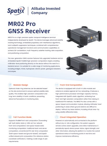 MR02 Pro
2 Pages
 Arc01 Receiver
2 Pages
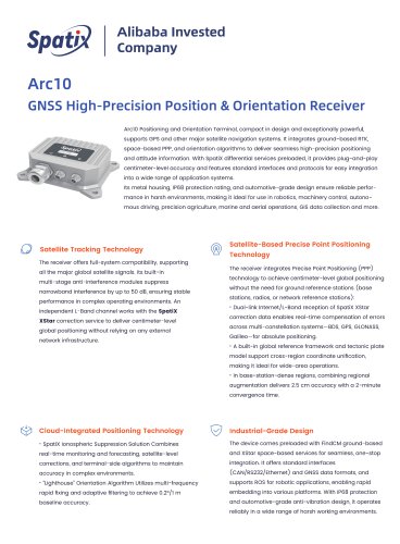 Arc10 Receiver
2 Pages
 iStation18
2 Pages
 ISOBUS
2 Pages
- 3D scanning system
- Industrial control system
- SpatiX GNSS receiver
- Inspection scanner
- Compact receiver
- Industrial receiver
- Digital control system
- Rugged receiver
- Monitoring control system
- Serial receiver
- Automatic control system
- Wireless receiver
- SpatiX RTK receiver
- USB receiver
- Portable scanner
- SpatiX surveying receiver
- GPS receiver
- Multi-frequency receiver
- Bluetooth receiver
- Tracking receiver