Arc01 Receiver
1 /2Pages
Arc01 Receiver
1 /2Pages
Catalog excerpts

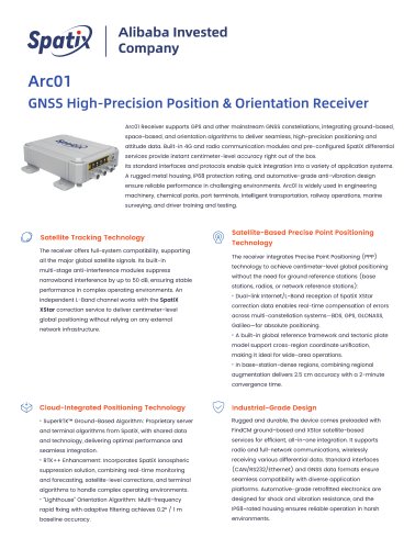
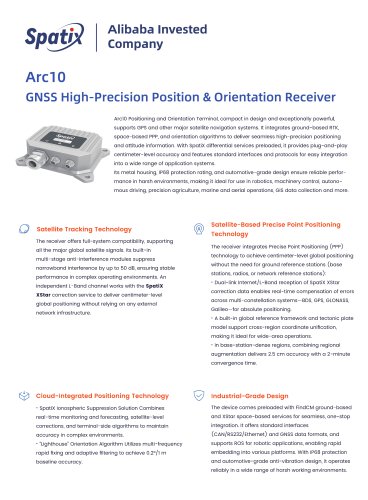
Alibaba Invested Company GNSS High-Precision Position & Orientation Receiver ArcOl Receiver supports GPS and other mainstream GNSS constellations, integrating ground-based, space-based, and orientation algorithms to deliver seamless, high-precision positioning and attitude data. Built-in 4G and radio communication modules and pre-configured SpatiX differential services provide instant centimeter-level accuracy right out of the box. Its standard interfaces and protocols enable quick integration into a variety of application systems. A rugged metal housing, IP68 protection rating, and automotive-grade anti-vibration design ensure reliable performance in challenging environments. ArcOl is widely used in engineering machinery, chemical parks, port terminals, intelligent transportation, railway operations, marine surveying, and driver training and testing. The receiver offers full-system compatibility, supporting all the major global satellite signals. Its built-in multi-stage anti-interference modules suppress narrowband interference by up to 50 dB, ensuring stable performance in complex operating environments. An independent L-Band channel works with the SpatiX XStar correction service to deliver centimeter-level global positioning without relying on any external network infrastructure. The receiver integrates Precise Point Positioning (ppp) technology to achieve centimeter-level global positioning without the need for ground reference stations (base stations, radios, or network reference stations): • Dual-link Internet/L-Band reception of SpatiX XStar correction data enables real-time compensation of errors across multi-constellation systems—BDS, GPS, GLONASS, Galileo—for absolute positioning. • A built-in global reference framework and tectonic plate model support cross-region coordinate unification, making it ideal for wide-area operations. • In base-station-dense regions, combining regional augmentation delivers 2.5 cm accuracy with a 2-minute convergence time. • SuperRTK™ Ground-Based Algorithm: Proprietary server and terminal algorithms from SpatiX, with shared data and technology, delivering optimal performance and seamless integration. • RTK++ Enhancement: Incorporates SpatiX ionospheric suppression solution, combining real-time monitoring and forecasting, satellite-level corrections, and terminal algorithms to handle complex operating environments. • “Lighthouse” Orientation Algorithm: Multi-frequency rapid fixing with adaptive filtering achieves 0.2° / 1 m baseline accuracy. Rugged and durable, the device comes preloaded with FindCM ground-based and XStar satellite-based services for efficient, all-in-one integration. It supports radio and full-network communications, wirelessly receiving various differential data. Standard interfaces (cAN/RS232/Ethernet) and GNSS data formats ensure seamless compatibility with diverse application platforms. Automotive-grade retrofitted electronics are designed for shock and vibration resistance, and the IP68-rated housing ensures reliable operation in harsh environments.
Open the catalog to page 1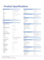
L-band SpatiXXStar Single Point Positioning Initialization Time Initialization Confidence Satellite-Based PPP Survey Horizontal Vertical Convergence Time Orientation Accuracy Static Survey Horizontal Vertical Velocity Accuracy Output Frequency Positioning Orientation Timing Accuracy Positioning Time PPP-RTK Fast Positioning < 2 min PPP-AR Standard Positioning < 6 min Raw Data Differential Data Position Data Others Multi-Function Interface (includes Power / CAN / RS232 or Ethernet / 1PPS) GNSS Primary Antenna GNSS Secondary Antenna Radio 4G Power Consumption Operating Temperature Storage Temperature...
Open the catalog to page 2All SpatiX catalogs and technical brochures
 Q800
Q8005 Pages
 Q700
Q7005 Pages
 SpatiX
11 Pages
 SpatiX CORS Solution
29 Pages
 X5
X55 Pages
 X3
X35 Pages
 QYX Pro
4 Pages
 S1
S14 Pages
 H7
H72 Pages
 iStation Pro GNSS Receiver
2 Pages
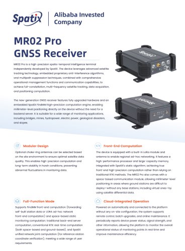 MR02 Pro
2 Pages
 Arc10 Receiver
2 Pages
 MX01
MX012 Pages
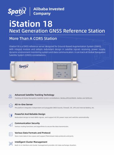 iStation18
2 Pages
 ISOBUS
2 Pages
- 3D scanning system
- Industrial control system
- SpatiX GNSS receiver
- Inspection scanner
- Compact receiver
- Industrial receiver
- Digital control system
- Rugged receiver
- Monitoring control system
- Serial receiver
- Automatic control system
- Wireless receiver
- SpatiX RTK receiver
- USB receiver
- Portable scanner
- SpatiX surveying receiver
- GPS receiver
- Multi-frequency receiver
- Bluetooth receiver
- Tracking receiver