- Catalogs
- South Surveying & Mapping Instrument Co., Ltd
- SOUTH Mini LiDAR system SZT-250 Map 3D Map
- Company
- Products
- Catalogs
- News & Trends
- Exhibitions
SOUTH Mini LiDAR system SZT-250 Map 3D Map
1 /2Pages

SOUTH Mini LiDAR system SZT-250 Map 3D Map
1 /2Pages
Catalog excerpts

LiDAR System Point density by flight speed and altitude
Open the catalog to page 1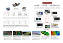
Several days or just a single day? LiDAR chooses for you! Z-Lab LiDAR-ctrl Inertial Explorer Z-Lab Pt-process Z-Lab Mapper TerraSolid Point Cloud Rendering (colorize to classify segment, density elevation, time, etc.) Point Cloud Cropping (cropped by gridding, facade, layer elevation, etc.) Point Cloud Accuracy Control (rectified by control points input & tie points matching) Note: the data shown above is based on flat terrain conditions for job reference only, and the estimated coverage per day is computed with 10 flights in total. Complex terrain of elevated areas or vegetated zones...
Open the catalog to page 2All South Surveying & Mapping Instrument Co., Ltd catalogs and technical brochures
 SOUTH MONITORING SYSTEM
21 Pages
 N4 Series
2 Pages
 N8 Series
2 Pages
 S750
S7502 Pages
 HX-U202 35W Radio
1 Page
 S86
S862 Pages
 S660N Brochure
2 Pages
 SOUTH Sky Cruiser UAV SYSTEM
2 Pages


Related Searches
- Measuring machine
- Touch screen tablet
- Wireless tablet
- Rugged tablet
- Bluetooth tablet
- WiFi tablet
- GNSS tablet
- Transceiver module
- Industrial tablet
- Windows tablet
- GPS tablet
- Android tablet
- Radio antenna
- Waterproof tablet
- 4 GB tablet
- 8 GB tablet
- Measurement monitoring module
- Tablet with NFC reader
- 4G LTE tablet
- Tablet PC
*Prices are pre-tax. They exclude delivery charges and customs duties and do not include additional charges for installation or activation options. Prices are indicative only and may vary by country, with changes to the cost of raw materials and exchange rates.