
- Catalogs
- South Surveying & Mapping Instrument Co., Ltd
- Professional Desktop Solution SOUTH SkyPhoto

- Company
- Products
- Catalogs
- News & Trends
- Exhibitions
Professional Desktop Solution SOUTH SkyPhoto

Professional Desktop Solution SOUTH SkyPhoto
This document provides an overview of the capabilities and specifications of South Surveying & Mapping Instrument Co., Ltd.'s aerial photogrammetry solutions. It is designed for both professional and non-professional mapping purposes, offering a range of tools for image processing and data analysis.
Specifications and Features
- Designed for checking the qualifications of acquired aerial images for post-processing.
- Suitable for use immediately after drone flights during fieldwork.
- Offers a time-saving and efficient solution for UAV pilots and post-processing handlers.
- Key features include imagery usability, missed flight zone detection, camera calibration matrix, POS coordinate information, overlap & sidelap percentage, and feature point matching.
- Supports power line inspection, traffic control, urban planning, environmental monitoring, and more.
- Camera self-calibration ensures output quality, processing up to 2,000 images per hour.
Mapping and Data Processing
- DLG (Digital Line Graph) is a key output, represented in digital vector form for GIS applications.
- Includes tools for aerial triangulation, camera calibration, and point cloud densification.
- Outputs include orthomosaic, DEM, DSM, TDOM, and 3D models.
- Software supports fast mosaic creation and precise DEM editing.
System Requirements
- Recommended configuration includes a 64-bit Windows 7/10 Professional Edition, Intel i7 or E series CPU, 16 GB RAM, and NVIDIA GeForce GTX 750 or above.
- Minimum configuration requires Intel i5 series CPU, 8 GB RAM, and NVIDIA GeForce GT 940Mx.
Conclusion
The system offers a comprehensive solution for transforming aerial images into digitized outputs, suitable for both specialists and beginners. It provides a variety of deliverables compatible with popular mapping and GIS software, ensuring high accuracy and productivity.
Catalog excerpts
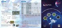
WORKFLOW SkyPhoto-QC ♦ Designed for checking the qualifications of acquired aerial images for post processing ♦ Perfect to be used the first time after drone flights during fieldwork ♦ A time-saving and high-efficiency solution for both UAV pilots and post-processing handlers Preparation Fieldwork/Outdoors - Camera calibration matrix I - POS coordinate information - Overlap & sidelap percentage - Overlapped pixels in imagery ■ - Skyway deviation/yaw angle deviation - Feature point matching SkyPhoto-lite mosaicKing • Specified for non-professional mapping purposes • Camera self-calibration enabled to guarantee the output quality • Several times faster than regular production, up to 2,000 images per hour • Engineered to immediate response and full view expectation • Precise distance or area calculation available in panoramagram mosaicKing best for, O Power Line Inspection O Immediate Analysis & Response O Traffic Control & Management O Resources Investigation & Documentation O Urban Planning & Management O City Component Updates O Environmental Protection & Monitoring SkyPhoto-advanced Being collected from geological survey maps and distributed in different scales, DLGs come in optional and Spatial Data Transfer Standard (SDTS) format and are topologically structured for use in mapping and Geographic Information System (GIS) applications. Handwheel and pedal are the typical tools for DLG production. SOUTH SURVEYING & MAPPING INSTRUMENT CO., LTD. Add: 2/F, Surveying Building, No. 26, Ke Yun Road, Tian He District, Guangzhou 510665, China Tel: +86-20-23380888 / 23380891 / 85524990 Fax: +86-20-85542136 / 23380800 E-mail: [email protected] [email protected] [email protected] [email protected] http://www.southsurvey.com http://www.southinstrument.com SOUTH Target your success
Open the catalog to page 1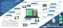
A Professional Desktop Solution for Aerial Photogrammetry FEATURES Co-developed with some professionals from Wuhan University, ranking top in Asia's geo-spatial industry area and academic field Smart Aerial Triangulation Optimized Matching Principle A sophisticated solution with remarkable accuracy, flexibility, usability and productivity The fast matching of feature points is very little restricted and quite friendly to tough cases with poor overlapping percentage, skyway deviation or sparse textures. The Semi Global Matching of Pyramid Hierarchical Principle (PH-SGM) plus the global optimization...
Open the catalog to page 2All South Surveying & Mapping Instrument Co., Ltd catalogs and technical brochures
 SOUTH MONITORING SYSTEM
21 Pages
 N4 Series
2 Pages
 N8 Series
2 Pages
 S750
S7502 Pages
 HX-U202 35W Radio
1 Page
 S86
S862 Pages
 S660N Brochure
2 Pages
 SOUTH Sky Cruiser UAV SYSTEM
2 Pages


- Measuring machine
- Touch screen tablet
- Wireless tablet
- Rugged tablet
- Bluetooth tablet
- WiFi tablet
- GNSS tablet
- Transceiver module
- Industrial tablet
- Windows tablet
- GPS tablet
- Radio antenna
- Android tablet
- Waterproof tablet
- 4 GB tablet
- 8 GB tablet
- Measurement monitoring module
- 4G LTE tablet
- Tablet with NFC reader
- Tablet PC