
Catalog excerpts

Shenzhen Keweitai Enterprise Development CO.,LTD Email: Alice.zhong@keweitai.com Whatsapp/Skype/Wechat No.:+8613660092062 ALLTECH UAV Surveying and Mapping Solution UAV surveying and mapping system Multi-rotor UAV flight system Surveying and Mapping System Multi-view optical aerial camera Differential RTK system (RTK airborne module and RTK ground Ubase) Multi-angle camera data preprocessing system Integrated ground station Hand-held remote controller High-end hardware system Modeling software system: ContextCapture imaging software Mapping UAV system composition diagram Work efficiency For example, at an altitude below 1000m, under 25 ℃ 1、Shooting efficiency: Rotor-wing UAV platform KWT-X6L-15 carried with multi-view optical aerial camera AMC536 (2.3kg), Effective working time for one flight is 50min Flight height 286 meters When the ground resolution is better than 5cm, the ground area of a single shot is not less than 1.5 square kilometers 2、Post-processing efficiency: With the preprocessing workstation and ContextCapture imaging software configured in this solution, the data processing time of 1km² does not exceed 36 ho
Open the catalog to page 1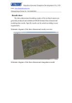
Shenzhen Keweitai Enterprise Development CO.,LTD Email: Alice.zhong@keweitai.com Whatsapp/Skype/Wechat No.:+8613660092062 Results show The three-dimensional modeling results of the inclined camera are generally produced and submitted (OSGB format) three-dimensional modeling data results. Specific results can be sorted according to user requirements. Schematic diagram of the three-dimensional results overview Schematic diagram of the three-dimensional triangulation model:
Open the catalog to page 2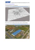
Shenzhen Keweitai Enterprise Development CO.,LTD Email: Alice.zhong@keweitai.com Whatsapp/Skype/Wechat No.:+8613660092062 Three-dimensional modeling details display (plant, cultivated land):
Open the catalog to page 3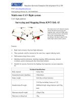
Shenzhen Keweitai Enterprise Development CO.,LTD Email: Alice.zhong@keweitai.com Whatsapp/Skype/Wechat No.:+8613660092062 The multi-rotor UAV platform mainly carries the load of surveying and mapping tasks, performs flight tasks, and records the position and attitude data at the corresponding time according to the photo signal of the multi-angle optical aerial camera. Features: > High wind resistance, big load, high endurance; > Three payloads could be mounted at the same time, support tethering mode; > Multi-purpose large drone system; > Matching load diversification, matching mapping, RTK...
Open the catalog to page 4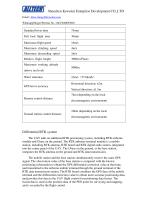
Shenzhen Keweitai Enterprise Development CO.,LTD Email: Alice.zhong@keweitai.com Whatsapp/Skype/Wechat No.:+8613660092062 Differential RTK system The UAV adds an additional RTK positioning system, including RTK airborne module and Ubase on the ground. The RTK airborne terminal module is a mobile station, including RTK antenna, RTK board and RTK digital radio station, integrated into the center panel of the UAV. The Ubase on the ground, as the base station, integrates the RTK antenna on the ground and RTK data transmission. The mobile station and the base station simultaneously receive the...
Open the catalog to page 5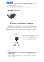
Shenzhen Keweitai Enterprise Development CO.,LTD Email: Alice.zhong@keweitai.com Whatsapp/Skype/Wechat No.:+8613660092062 RTK/PPK Ground terminal Integrated Ground Station System SPELL-IG The Integrated ground station system is a multi-function system integrated with high-definition image receiving & display, data transmission link and multi-function ground station. Using the SPELL series, aircraft can easily achieve FPV flight and control. The integrated ground station completes the route planning, controls the UAV to perform tasks autonomously, and displays the route, exposure point, UAV...
Open the catalog to page 6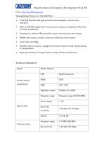
Shenzhen Keweitai Enterprise Development CO.,LTD Email: Alice.zhong@keweitai.com Whatsapp/Skype/Wechat No.:+8613660092062 > Track ball keyboard and high-precision electromagnetic stylus for easy operation; > Built-in 900 MHz digital radio with automatic frequency hopping to effectively avoid the interference; > Simultaneous airborne HD transmitter image receiving and screen display; > HDMI video output, external connection with large screen display; > Local video recording; > Portable suitcase structure, equipped with tripod, small size and simple packing & transportation; > High-gain...
Open the catalog to page 7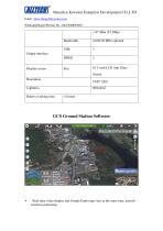
Shenzhen Keweitai Enterprise Development CO.,LTD Email: Alice.zhong@keweitai.com Whatsapp/Skype/Wechat No.:+8613660092062 > Real-time video display and Google Earth map view at the same time, aircraft location positioning
Open the catalog to page 8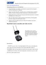
Shenzhen Keweitai Enterprise Development CO.,LTD Email: Alice.zhong@keweitai.com Whatsapp/Skype/Wechat No.:+8613660092062 Google Earth full screen display, accurately set waypoint tasks and support real-time modification of waypoints Support one-button take-off, one-button cruise, one-button return, one-button landing, emergency landing and other shortcut keys with friendly interface Flight path/critical event SD card storage and information playback to reproduce the flight process of the aircraft Full voice alarm prompt, support automatic route planning, tilt photography parameter setting...
Open the catalog to page 9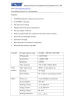
Shenzhen Keweitai Enterprise Development CO.,LTD Email: Alice.zhong@keweitai.com Whatsapp/Skype/Wechat No.:+8613660092062 Features > COFDM demodulation, high receiving sensitivity > H.264/MPEG-2 decoding > HD output and recording > Multiple-channel storage and management > One-key channel switchover > Small size, light weight, easy connection to the drone remote controller > Removable and changeable antennas > Quick power charging > Full UI interface for parameters configuration > Bandwidth and frequency adjustable
Open the catalog to page 10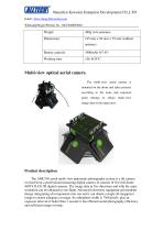
Shenzhen Keweitai Enterprise Development CO.,LTD Email: Alice.zhong@keweitai.com Whatsapp/Skype/Wechat No.:+8613660092062 Battery capacity Working time Multi-view optical aerial camera The multi-view aerial camera is mounted on the drone and takes pictures according to the route and exposure point settings to obtain multi-view image data in the target area. Product description The AMC536 aerial multi-view panoramic photography system is a tilt camera evolved from a professional measuring digital camera. It consists of five full-frame SONY ILCE-7R digital cameras. The image data in five...
Open the catalog to page 11All Shenzhen Keweitai Enterprise Development Co. catalogs and technical brochures
-
ALLTECH Drone Catalog2020.pdf
30 Pages
-
VTOL fixed wing KWT-GM360-H
4 Pages
-
Police drone KWT-Z4M-H
23 Pages
-
KWT-X6H Hybrid Multicopter
11 Pages
-
Anti_drone_system_KWT-FZQ
2 Pages


