- Catalogs
- SatLab Geosolutions AB
- Cygnus3-Brochure-EN-20260515s
- Company
- Products
- Catalogs
- News & Trends
- Exhibitions
Cygnus3-Brochure-EN-20260515s
1 /2Pages
Cygnus3-Brochure-EN-20260515s
1 /2Pages
Catalog excerpts

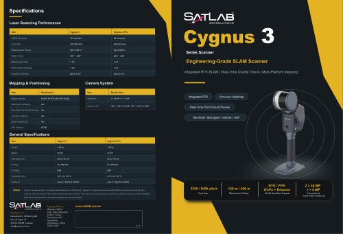
Laser Scanning Performance Cygnus 3 Series Scanner Integrated RTK-SLAM | Real-Time Quality Check | Multi-Platform Mapping Mapping & Positioning Camera System Accuracy Heatmap Real-Time Point Cloud Preview Handheld / Backpack / Vehicle / UAV General Specifications Notes Cygnus 3 is equipped with a 16-channel LiDAR delivering up to 320,000 pts/s. Cygnus 3 Pro features a 32-channel LiDAR with a point rate of up to 640,000 pts/s. Accuracy values are obtained under satlab standard calibration conditions. Performance may vary depending on environment, operating method, and GNSS availability. Battery endurance depends on operating temperature and working conditions. Geosolution i Goteborg AB Stora Avagen 21 436 34 ASKIM, Sweden [email protected] Regional Offices: Warsaw, Poland Jian, Czech Republic Ankara, Turkey Scottsdale, USA Singapore Hong Kong, China Dubai, UAE RTK/PPK GCPs + Resume SLAM Workflow Support Colorization & Visual-Aided Positioning
Open the catalog to page 1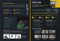
series Scanner Cygnus 3 is built for complex indoor, outdoor, and GNSS-challenged environments. It combines LiDAR, vision, RTK positioning, and advanced SLAM algorithms to deliver reliable 3D data for surveying, construction, infrastructure, and digital twin workflows. Accuracy Heatmap Multi-Platform Mapping Rich Deliverables Built-in RTK for globally consistent point cloud results. Handheld, backpack, vehicle, and UAV operation. Check data quality directly during field scanning. SAT-LIDAR SOFTWARE WORKFLOW From SLAM Data to Engineering Deliverables Cygnus 3 works with Sat-LiDAR to connect field...
Open the catalog to page 2All SatLab Geosolutions AB catalogs and technical brochures
 SatLab/ADCP/ HydroFlow
4 Pages
 SatLab/GNSS Receiver/ Njord
2 Pages
 SatLab/USV/ HydroBoat 990
4 Pages
 SatLab/USV/ HydroBoat 1200
4 Pages
 SatLab/USV/ HydroBoat 1500
4 Pages
 Eyr-Brochure-EN-20230626-s
4 Pages
 SL7-Brochure-EN-20230629-s
2 Pages
 Freyja-Brochure-EN
2 Pages
 SatLab/GNSS Receiver/ SL700
2 Pages
 SatLab/GNSS Receiver/ SL900
2 Pages
 SatLab/GNSS Receiver/ SL800
2 Pages
 SatLab/GNSS Receiver/ SL600
6 Pages
 SatLab/Software/ Satsurv
2 Pages
 SatLab/Rugged Pad/ SL86
2 Pages
 SatLab/Rugged Tablet/ SL11
2 Pages


Archived catalogs

- HS CAD software
- HS cloud software
- HS touch screen tablet
- HS wireless tablet
- HS rugged tablet
- Measurement software
- HS Bluetooth tablet
- HS WiFi tablet
- HS GNSS tablet
- HS industrial tablet
- HS Windows tablet
- HS GPS tablet
- HS Android tablet
- EDM software
- HS engineering software
- HS waterproof tablet
- HS 4 GB tablet
- 2D software
- HS radio receiver
- Environmental monitoring system