- Company
- Products
- Catalogs
- News & Trends
- Exhibitions
VUX-160²³
1 /6Pages

VUX-160²³
1 /6Pages
Catalog excerpts

„NFB“ (Nadir/Forward/Backward) Scanning UAV LiDAR Sensor • laser pulse repetition rate up to 2.4 MHz • measurement rate up to 2,000,000 meas./sec • scan speed up to 400 lines/second • operating flight altitude up to 900 m / 2,950 ft • Field of View up to 100° • compact & lightweight (2.65 kg / 5.8 lbs) • Nadir/Forward/Backward Scanning for unrivaled completeness of scan data even on vertical structures and narrow canyons • cutting edge RIEGL technology providing: - echo signal digitization - multiple target capability - online waveform processing - multiple-time-around processing • easily mountable to unmanned platforms (UAVs) and small manned aircraft • mechanical and electrical interface for IMU/GNSS integration • interfaces for up to 5 external cameras • scan data storage on internal SSD Memory • removeable CFAST® memory card The RIEGL VUX-16023 is a lightweight and versatile airborne laser scanner offering a wide field of view of 100 degrees and an extremely high pulse repetition rate of up to 2.4 MHz. Thus, it is perfectly suited for high point density corridor mapping applications. The measuring beam of the RIEGL VUX-16023 is consecutively emitted in three different directions: it alternates from strictly nadir, to +10 degrees forward, and to -10 degrees backward. This allows data acquisition with an unrivaled completeness in data capture, especially in challenging environments with vertical surfaces and narrow canyons. The scanner provides an internal data storage capacity of 2 TByte and a removeable CFast card and is equipped with interfaces for integration of an external IMU/GNSS system. Additionally, interfaces for up to five optional external cameras are available. The sophisticated design of the RIEGL VUX-16023 allows smooth integration on UAS/UAV/RPAS, small manned aeroplanes (like gyrocopters), but also on helicopters. It is offered both, as stand-alone UAV LiDAR sensor and also in various fully-integrated UAV-based laser scanning system configurations with appropriate IMU/GNSS system and optional cameras. This allows the scanner to perfectly meet all the specific requirements of the customers‘ applications. Typical applications include • Corridor Mapping: Power Line, Railway Track and Pipeline Inspection • Topography in Open-Cast Mining • Surveying of Urban Environments • Archeology and Cultural Heritage Documentation • Agriculture & Forestry visit our website www.rieg
Open the catalog to page 1
RIEGL VUX-16023 Scan Pattern „NFB“ (Nadir/Forward/Backward) top view side view Forward Scan Line Nadir Scan Line Backward Scan Line Nadir Scanning Flight Direction Forward/Backward Scan Angle in Swath Center Forward/Backward Scan Angle at Swath Edges The RIEGL VUX-16023 offers a sophisticated scan pattern consisting of scan lines with periodically changing directions. The scan directions in the center of the scan lines change consecutively from strictly nadir, to +10 degrees forward, and to -10 degrees backward. This scan pattern provides an almost complete 3D data set, as also vertical surfaces...
Open the catalog to page 2
Maximum Measurement Range & Point Density RIEGL VUX®-16023 Operating Flight Altitude AGL given for the following conditions: FOV 100°, ambiguity resolved by multiple-time-around (MTA) processing, average ambient brightness, target size ≥ laser footprint, roll angle <±5 deg Example: VUX-16023 at 300,000 pulses/sec, laser power level 100% altitude 1,800 ft AGL, speed 60 kn, resulting point density ~ 6.2 pts/m² Operating Flight Altitude AGL given for the following conditions: FOV 100°, ambiguity resolved by multiple-time-around (MTA) processing, average ambient brightness, target size ≥ laser footprint,...
Open the catalog to page 3
Maximum Measurement Range & Point Density RIEGL VUX®-16023 Operating Flight Altitude AGL given for the following conditions: FOV 100°, ambiguity resolved by multiple-time-around (MTA) processing, average ambient brightness, target size ≥ laser footprint, roll angle <±5 deg Example: VUX-16023 at 1,800,000 pulses/sec, laser power level 100% altitude 550 ft AGL, speed 30 kn, resulting point density ~ 243 pts/m² Operating Flight Altitude AGL given for the following conditions: FOV 100°, ambiguity resolved by multiple-time-around (MTA) processing, average ambient brightness, target size ≥ laser footprint,...
Open the catalog to page 4
Technical Data RIEGL VUX®-16023 Laser Product Classification Class 1 Laser Product according to IEC60825-1:2014 The following clause applies for instruments delivered into the United States: Complies with 21 CFR 1040.10 and 1040.11 except for conformance with IEC 60825-1 Ed.3., as described in Laser Notice No. 56, dated May 8, 2019. Range Measurement Performance Measuring Principle Laser Pulse Repetition Rate PRR 1) Max. Measuring Range 2) 3) natural targets ≥ 20 % natural targets ≥ 60 % natural targets ≥ 80 % Max. Operating Flight Altitude AGL 2) 4) @ ≥ 20 % @ ≥ 60 % time of flight...
Open the catalog to page 5
Dimensional Drawings RIEGL VUX®-16023 RIEGL VUX-16023 UAV LiDAR Sensor with Connection Box RIEGL VUX-16023-SYS System Integration The RIEGL VUX-16023 can be optionally complemented with an appropriate IMU/GNSS system. AP+board (fully integrated) External IMU & GNSS (optional) Applanix AP+30 1) Applanix AP+50 1) IMU Accuracy Roll, Pitch 0.010° 0.005° Heading 0.025° 0.010° IMU Sampling Rate 200 Hz 200 Hz Position Accuracy (typ.) 0.02 - 0.05 m 0.02 - 0.05 m System Total Weight (approx.) 3) 3.15 kg 3.15 kg 2) See technical details at the according Applanix datasheet Accuracy specifications for post-processed...
Open the catalog to page 6All RIEGL LMS catalogs and technical brochures
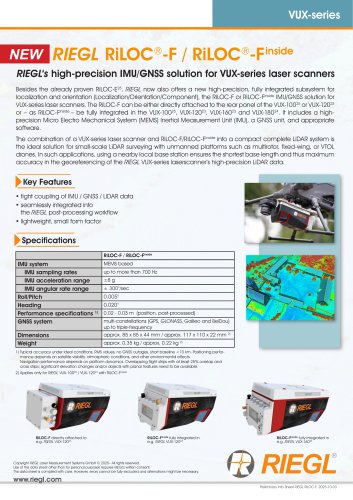 RiLOC-F / RiLOC-F-inside
1 Page
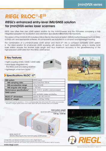 RIEGL RiLOC-E-25
1 Page
 RiACQUIRE
4 Pages
 RIEGL VMX-2HA
8 Pages
 RIEGL VZ-4000i-25
8 Pages
 RIEGL VQ-860-G
6 Pages
 RIEGL VQ-840-GL
6 Pages
 RIEGL VZ-2000i
10 Pages
 RIEGL VQX-1 Wing Pod
4 Pages
 RIEGL VQ-580 II-S
8 Pages
 RIEGL VQ-1560 III-S
10 Pages
 RIEGL VQ-1260
10 Pages
 RIEGL VQ-1460
10 Pages
 RIEGL VPX-1
2 Pages
 RIEGL Monitoring Apps
4 Pages
 RIEGL VMY-1
4 Pages
 RIEGL VQ-680
8 Pages
 RIEGL VMY-2
8 Pages
 RIEGL V-Line CB23
2 Pages
 RIEGL VMQ -1HA
6 Pages
 RIEGL LD05e-A30-PH67
5 Pages
 RIEGL VZ-600i
8 Pages
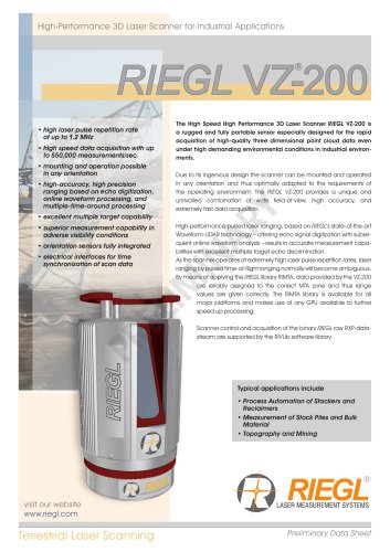 RIEGL VZ-200
6 Pages
 RIEGL VQ-840-G
6 Pages
 RIEGL VQ-840-GE
6 Pages
 RiMINING
4 Pages
 RIEGL VUX-180-24
6 Pages
 RIEGL VUX-240-24
6 Pages
 RIEGL VUX-120²³
8 Pages
 RIEGL miniVUX-3UAV
6 Pages
 RIEGL V-Line UB23
2 Pages
 RIEGL BLS Overview
1 Page
 LIS TreeAnalyzer Plugin
2 Pages
 RIEGL VZ-400i
10 Pages
 RIEGL VMX-RAIL
6 Pages
 LIS GeoTec Plugin
2 Pages
 RIEGL VQ-480 II
6 Pages
 RIEGL VMR
4 Pages
 RDBLib
2 Pages
 RiSOLVE
4 Pages
 RIEGL VQ-1560 II-S
10 Pages
 RIEGL VQ-780 II-S
8 Pages
 RIEGL VQ-780 II
8 Pages
 RIEGL LD05-A10GF
10 Pages
 LD05e-A10, LD05e-A30
4 Pages
 RIEGL VUX-240
6 Pages
 RIEGL VQ-580 II
6 Pages
 RiPROCESS
4 Pages
 RIEGL VQX-2 Helicopter Pod
4 Pages
 RIEGL ULS Overview
1 Page
 RIEGL ALS Overview
1 Page
 RIEGL VMX-2HA-BC
2 Pages
 RIEGL PH-VUX
2 Pages
 RIEGL Topo-Bathymetry
4 Pages
 RIEGL miniVUX-SYS
4 Pages
 RIEGL VUX-1UAV-22
6 Pages
 RIEGL VUX-1HA-22
4 Pages
 RIEGL VUX-1LR-22
6 Pages
 RIEGL UAV Sensors & Systems
2 Pages
 RiSCAN PRO
4 Pages
 RIEGL VUX-SYS
4 Pages
 RIEGL VZ-400i
2 Pages
 RIEGL miniVUX-1UAV
4 Pages
 RiVLib
4 Pages
 RiUNITE
4 Pages
 RIEGL VQ-1560i-DW
10 Pages
 RIEGL VMZ
4 Pages
 RIEGL VZ-6000
6 Pages
 RiPANO
4 Pages
 RIEGL DR1560i
2 Pages
 RiHYDRO
2 Pages
 RIEGL LD05e-HT
4 Pages
 RIEGL LD05-HTGF
13 Pages
 RIEGL VZ-2000i
2 Pages


Archived catalogs
 RIEGL VZ-4000
6 Pages
 RIEGL miniVUX-1LR
4 Pages
 RIEGL miniVUX-2UAV
4 Pages
 RIEGL LD05-A80
5 Pages