- Company
- Products
- Catalogs
- News & Trends
- Exhibitions
RiSCAN PRO
1 /4Pages

RiSCAN PRO
1 /4Pages
Catalog excerpts
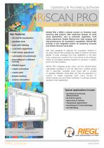
Operating & Processing Software RiSCAN PRO for RIEGL 3D Laser Scanners Key Features: • 2D and 3D visualization • geodetic tools • automatic filtering • automatic registration • multi station adjustment • colorization of pointclouds • import/export in different formats • RiPANO export • create animations • create plots • simple meshing • volume calculation RiSCAN PRO is RIEGL’s software solution for Terrestrial Laser Scanning (TLS) projects. With advanced features for point cloud optimization, such as automatic registration, multi station adjustment, flexible filtering tools, data merging, and high-performance 3D visualization capabilities, RiSCAN PRO provides a fully integrated solution for producing accurate and refined TLS point cloud data. With tools designed to optimize the acquisition workflow in the field, RiSCAN PRO provides the ability to perform real-time QA/QC of data coverage and scan registration in the field. Data is streamed in real-time from the scanner to the software, where all processing features required to produce a perfect point cloud are provided. RiSCAN PRO integrates sensor fusion and the transformation capabilities necessary to turn the data from multiple sensors into a seamless, colorized point cloud with a number of valuable attributes. These data can then be exported in a number of widely supported point cloud formats for further analysis and information extraction in software solutions tailored to each application. Typical applications include • Architecture & Facade Measurements • As-built Surveying • Agriculture & Forestry • Topography Applications • Archeology & Cultural Heritage • City Modeling visit our website www.ri
Open the catalog to page 1
RiSCAN PRO General Information Automatic Registration Automatic merging of point clouds from different scan positions. Especially tailored for VZ-i Series Scanners, it enables fast registration of hundreds of scan positions with no user interaction necessary. Multi Station Adjustment MSA= Optimization of all scan positions, so that • can data from neighboring scan s positions match • GNSS measurements match scan positions • measurements from tilt sensors match scan position‘s orientation • scan data match externally surveyed control points statistically correct optimization with correct measurement...
Open the catalog to page 2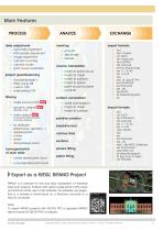
Main Features PROCESS data adjustment • • • • • • automatic registration MSA bundle adjustment image adjustment camera mounting camera model point cloud colorization • smooth • decimate • texture volume calculation • • • • • • project georeferencing • • • • GeoSysManager 2 EPSG online DB custom CRS engineering CRS mesh to point cloud mesh to mesh mesh to surface mesh to plane point cloud to plane cut & fill surface comparison • single source points NEW • dynamic objects NEW (people, cars, ...) (caused by glas facades or similar objects) • voxel comparison • mesh to mesh • mesh to surface polyline...
Open the catalog to page 3
One Touch Processing Wizard Task 1: convert scans Task 2: filter scans Task 3: register scan positions Task 4: fine adjust project Task 5: calibrate camera mounting Task 6: colorize scans from photos Task 7: mark single source points Task 8: mark dynamic objects Task 9: generate octree based point clouds Task 10: create 3D views Task 11: create ortho plots Task 12: export as RiPANO Task 13: export as LAS Task 14: create video renderings The One Touch Processing Wizard allows you to automate key processing steps. The result is a registered, adjusted, colored and homogenized point cloud. It is...
Open the catalog to page 4All RIEGL LMS catalogs and technical brochures
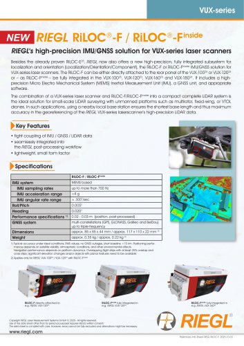 RiLOC-F / RiLOC-F-inside
1 Page
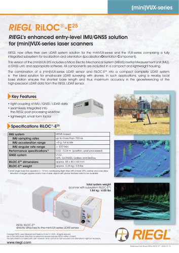 RIEGL RiLOC-E-25
1 Page
 RiACQUIRE
4 Pages
 RIEGL VMX-2HA
8 Pages
 RIEGL VZ-4000i-25
8 Pages
 RIEGL VQ-860-G
6 Pages
 RIEGL VQ-840-GL
6 Pages
 RIEGL VZ-2000i
10 Pages
 RIEGL VQX-1 Wing Pod
4 Pages
 RIEGL VQ-580 II-S
8 Pages
 RIEGL VQ-1560 III-S
10 Pages
 RIEGL VQ-1260
10 Pages
 RIEGL VQ-1460
10 Pages
 RIEGL VPX-1
2 Pages
 RIEGL Monitoring Apps
4 Pages
 RIEGL VMY-1
4 Pages
 RIEGL VQ-680
8 Pages
 RIEGL VMY-2
8 Pages
 RIEGL V-Line CB23
2 Pages
 RIEGL VMQ -1HA
6 Pages
 RIEGL LD05e-A30-PH67
5 Pages
 RIEGL VZ-600i
8 Pages
 RIEGL VZ-200
6 Pages
 RIEGL VQ-840-G
6 Pages
 RIEGL VQ-840-GE
6 Pages
 RiMINING
4 Pages
 RIEGL VUX-180-24
6 Pages
 RIEGL VUX-240-24
6 Pages
 VUX-160²³
6 Pages
 RIEGL VUX-120²³
8 Pages
 RIEGL miniVUX-3UAV
6 Pages
 RIEGL V-Line UB23
2 Pages
 RIEGL BLS Overview
1 Page
 LIS TreeAnalyzer Plugin
2 Pages
 RIEGL VZ-400i
10 Pages
 RIEGL VMX-RAIL
6 Pages
 LIS GeoTec Plugin
2 Pages
 RIEGL VQ-480 II
6 Pages
 RIEGL VMR
4 Pages
 RDBLib
2 Pages
 RiSOLVE
4 Pages
 RIEGL VQ-1560 II-S
10 Pages
 RIEGL VQ-780 II-S
8 Pages
 RIEGL VQ-780 II
8 Pages
 RIEGL LD05-A10GF
10 Pages
 LD05e-A10, LD05e-A30
4 Pages
 RIEGL VUX-240
6 Pages
 RIEGL VQ-580 II
6 Pages
 RiPROCESS
4 Pages
 RIEGL VQX-2 Helicopter Pod
4 Pages
 RIEGL ULS Overview
1 Page
 RIEGL ALS Overview
1 Page
 RIEGL VMX-2HA-BC
2 Pages
 RIEGL PH-VUX
2 Pages
 RIEGL Topo-Bathymetry
4 Pages
 RIEGL miniVUX-SYS
4 Pages
 RIEGL VUX-1UAV-22
6 Pages
 RIEGL VUX-1HA-22
4 Pages
 RIEGL VUX-1LR-22
6 Pages
 RIEGL UAV Sensors & Systems
2 Pages
 RIEGL VUX-SYS
4 Pages
 RIEGL VZ-400i
2 Pages
 RIEGL miniVUX-1UAV
4 Pages
 RiVLib
4 Pages
 RiUNITE
4 Pages
 RIEGL VQ-1560i-DW
10 Pages
 RIEGL VMZ
4 Pages
 RIEGL VZ-6000
6 Pages
 RiPANO
4 Pages
 RIEGL DR1560i
2 Pages
 RiHYDRO
2 Pages
 RIEGL LD05e-HT
4 Pages
 RIEGL LD05-HTGF
13 Pages
 RIEGL VZ-2000i
2 Pages


Archived catalogs
 RIEGL VZ-4000
6 Pages
 RIEGL miniVUX-1LR
4 Pages
 RIEGL miniVUX-2UAV
4 Pages
 RIEGL LD05-A80
5 Pages
- 3D scanning system
- Measurement scanner
- XY scanner
- High-resolution scanner
- Compact scanner
- High-speed scanner
- High-precision scanner
- Portable scanner
- Rangefinder
- Laser rangefinder
- Scanning system
- LIDAR sensor
- Integrated scanner
- LIDAR scanner
- Mobile scanner
- Ethernet scanner
- Non-contact scanner
- Rugged scanner
- Wireless scanner