- Company
- Products
- Catalogs
- News & Trends
- Exhibitions
RIEGL VZ-2000i
1 /10Pages

RIEGL VZ-2000i
1 /10Pages
Catalog excerpts

Long Range, Very High Speed 3D Laser Scanner RIEGL VZ-2000i • v>' w. • high laser pulse repetition rate of up to 1.2 MHz • high speed data acquisition with up to 500,000 measurements/sec • eye safe operation at Laser Class 1 wide field of view 100°x360 igh accuracy, high precisio, ranging based on echo digitization, online waveform processing, and multiple-time-around processing innovative processing architecture for data acquisition and simultaneous geo-referencing, in real-time • automatic on-board registration scan data acquisition cloud connectivity via Wi-Fi and and kinematic data ac • multiple target capabi optional waveform remote control intearated GNSS re Based on a future-oriented, innovative processing architecture, internet connectivity, and RIEGL’s latest waveform processing LiDAR technology, the RIEGL VZ-2000i Long Range 3D Laser Scanning System combines proven user friendliness in the field with fast and highly accurate data acquisition. Its processing architecture enables execution of different background tasks (such as point cloud registration, geo-referencing, orientation via integrated Inertial Measurement Unit, etc.) on-board in parallel to the simultaneous acquisition of scan data and image data. A full documentation of the scanner's software components - directly accessible on the RIEGL VZ-2000i - provides a sound basis for creation of your own python apps to enhance the scanner functionality. The system provides highest flexibility by supporting numerous peripherals and accessories such as the integrated GNSS unit for high accurate RTK solution, a SIM Card slot for 3G/4G LTE, WLAN, LAN, USB, and different other ports of external units. RIEGL's unique Waveform-LiDAR technology - based on echo digitization, online waveform processing, and multiple-time-around processing - is the key to enabling such high speed, long range, high accuracy measurements even in poor visibility and demanding multitarget situations caused by dust, haze, rain, vegetation, etc. visit our website www.riegl.com Terrestrial Laser Scanning Typical applications include • Natural Hazard Surveying • Construction Site Monitoring • Archeology & Cultural Heritage Documentation • City Modeling • Tunnel Surveying • Civil Engineering RIEGL LASER MEASUREMENT SYSTEMS Data Sheet
Open the catalog to page 1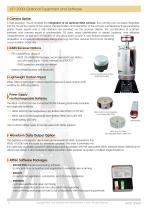
VZ®-2000i Optional Equipment and Software Camera Option A DSLR camera or the RIEGL VZ-i-20M heavy duty camera can be integrated using a high-precision camera mount. Power supply and USB interface are provided via the scanner directly. Acquisition of images simultaneously during scanning reduces the time for handling a scan position drastically. GNSS Receiver Options >> RTK capability by using of: - RIEGL VZ-i GNSS RTK Receiver, recommended base station via LoRa radio (up to 10 km), network, or NTRIP/TCP - GNSS correction service via internet >> external GNSS Receiver via data-cable or Bluetooth...
Open the catalog to page 2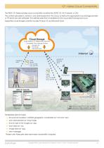
VZ®-i Series Cloud Connectivity The RIEGL VZ-i Series provides cloud connectivity via either the 3G/4G LTE, Wi-Fi network, or LAN. The content uploaded to, stored in, and downloaded from the cloud, as well as the appropriate cloud storage provider or FTP server are user definable. The defined data then is transferred to the cloud after finishing each scan. Supported cloud storage currently includes Amazon S3 and Microsoft Azure. Cloud Storage (Data stored in VZ-i Series project structure) Compatible Cloud Storage Options: Amazon S3 FTP Server Microsoft Azure data email e.g. .kml file e.g. .json...
Open the catalog to page 3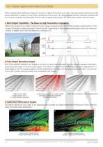
VZ®-i Series Highly Informative Scan Data RIEGL‘s sophisticated LiDAR technology is the basis for highly informative scan data. Every laser pulse received provides several attributes in addition to the range measurement information. By using different features and filters provided with the scanner’s software, this information can be used to significantly improve the informative content of point clouds. Multi Target Capability - the Basis for High Penetration Capability Utilizing the pulsed time-of-flight method for laser range measurements, the VZ-2000i enables determination of the range to all...
Open the catalog to page 4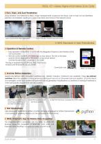
RIEGL VZ®-i Series Highly Informative Scan Data Rain, Haze, and Dust Penetration Using deviation and reflectance filters, range measurements caused by rain drops, dust or haze can be identified, selected, and deleted, resulting in a clear and clean point cloud of the relevant scene. point cloud before filter application automatically cleaned-up point cloud A NEW Standard in User-Friendliness Operation & Remote Control >> Easy operation of the RIEGL VZ-2000i with the integrated Graphical User Interface (GUI) via touchscreen. >> Remote control via RIEGL VZ-i Series App on your device. The GUI of...
Open the catalog to page 5
Automatic On-board Registration Matching point clouds of different scan positions (registration) has always been one of the most time-consuming tasks during the post-processing of 3D scanning projects. With two processors on-board, the RIEGL VZ-2000i carries out some post-processing tasks in real-time such as automatic on-board registration in parallel to the scan data acquisition. Find here some examples on how this feature may be utilized to fasten the registration process in open-pit mine surveying. Merging of Scan Positions The on-board sensors (GNSS, mems-IMU, compass) deliver a rough orientation...
Open the catalog to page 6
RIEGL VZ®-2000i Field Experience Open-Pit Mining The real-time on-board registered pointclouds can be directly uploaded to a remote storage and to the cloud for applying further automated analysis steps common in monitoring, autonomous machine control, volume calculations, blast planning, and break line extraction. Scanning parameters: • mining area > 8 km² • 5 scan positions • 50 kHz measurement rate • > 8 million points / scan range 0 - 2500 m scan data of an open-pit mining area, range-colored Railroad Surveying In the example illustrated here, the RIEGL VZ-2000i acquired scan data of a railway...
Open the catalog to page 7All RIEGL LMS catalogs and technical brochures
 RiLOC-F / RiLOC-F-inside
1 Page
 RIEGL RiLOC-E-25
1 Page
 RiACQUIRE
4 Pages
 RIEGL VMX-2HA
8 Pages
 RIEGL VZ-4000i-25
8 Pages
 RIEGL VQ-860-G
6 Pages
 RIEGL VQ-840-GL
6 Pages
 RIEGL VQX-1 Wing Pod
4 Pages
 RIEGL VQ-580 II-S
8 Pages
 RIEGL VQ-1560 III-S
10 Pages
 RIEGL VQ-1260
10 Pages
 RIEGL VQ-1460
10 Pages
 RIEGL VPX-1
2 Pages
 RIEGL Monitoring Apps
4 Pages
 RIEGL VMY-1
4 Pages
 RIEGL VQ-680
8 Pages
 RIEGL VMY-2
8 Pages
 RIEGL V-Line CB23
2 Pages
 RIEGL VMQ -1HA
6 Pages
 RIEGL LD05e-A30-PH67
5 Pages
 RIEGL VZ-600i
8 Pages
 RIEGL VZ-200
6 Pages
 RIEGL VQ-840-G
6 Pages
 RIEGL VQ-840-GE
6 Pages
 RiMINING
4 Pages
 RIEGL VUX-180-24
6 Pages
 RIEGL VUX-240-24
6 Pages
 VUX-160²³
6 Pages
 RIEGL VUX-120²³
8 Pages
 RIEGL miniVUX-3UAV
6 Pages
 RIEGL V-Line UB23
2 Pages
 RIEGL BLS Overview
1 Page
 LIS TreeAnalyzer Plugin
2 Pages
 RIEGL VZ-400i
10 Pages
 RIEGL VMX-RAIL
6 Pages
 LIS GeoTec Plugin
2 Pages
 RIEGL VQ-480 II
6 Pages
 RIEGL VMR
4 Pages
 RDBLib
2 Pages
 RiSOLVE
4 Pages
 RIEGL VQ-1560 II-S
10 Pages
 RIEGL VQ-780 II-S
8 Pages
 RIEGL VQ-780 II
8 Pages
 RIEGL LD05-A10GF
10 Pages
 LD05e-A10, LD05e-A30
4 Pages
 RIEGL VUX-240
6 Pages
 RIEGL VQ-580 II
6 Pages
 RiPROCESS
4 Pages
 RIEGL VQX-2 Helicopter Pod
4 Pages
 RIEGL ULS Overview
1 Page
 RIEGL ALS Overview
1 Page
 RIEGL VMX-2HA-BC
2 Pages
 RIEGL PH-VUX
2 Pages
 RIEGL Topo-Bathymetry
4 Pages
 RIEGL miniVUX-SYS
4 Pages
 RIEGL VUX-1UAV-22
6 Pages
 RIEGL VUX-1HA-22
4 Pages
 RIEGL VUX-1LR-22
6 Pages
 RIEGL UAV Sensors & Systems
2 Pages
 RiSCAN PRO
4 Pages
 RIEGL VUX-SYS
4 Pages
 RIEGL VZ-400i
2 Pages
 RIEGL miniVUX-1UAV
4 Pages
 RiVLib
4 Pages
 RiUNITE
4 Pages
 RIEGL VQ-1560i-DW
10 Pages
 RIEGL VMZ
4 Pages
 RIEGL VZ-6000
6 Pages
 RiPANO
4 Pages
 RIEGL DR1560i
2 Pages
 RiHYDRO
2 Pages
 RIEGL LD05e-HT
4 Pages
 RIEGL LD05-HTGF
13 Pages
 RIEGL VZ-2000i
2 Pages


Archived catalogs
 RIEGL VZ-4000
6 Pages
 RIEGL miniVUX-1LR
4 Pages
 RIEGL miniVUX-2UAV
4 Pages
 RIEGL LD05-A80
5 Pages