- Company
- Products
- Catalogs
- News & Trends
- Exhibitions
RIEGL VQ-860-G
1 /6Pages

RIEGL VQ-860-G
1 /6Pages
Catalog excerpts

High Performance Topo-Bathymetric Airborne Laser Scanner with Online Waveform Processing and Full Waveform Recording L VQ-860-G EXCELLENT DEPTH PERFORMANCE wide operational envelope: high accuracy ranging based on echo digitization and online waveform processing with multiple-target capability concurrent comprehensive full vaveform storage of all measure-for subsequent waveform """HlRi • high spatial resolution due to measurement rates of up to 100 kHz i and high scanning speed of up to • IMU/GNSS system and digital camera (optionally integrated) oact and robust design ihigh autonomy provided by large : ' internal storage capacity provides operational mode with reduced laser power to adapt to eye-safety requirements in sensitive areas The RIEGL® VQ-860-G airborne laser scanner with increased performance enhances depth penetration in surveying inland waters and near shore waters for even more efficiency in bathymetric applications. The complete system is offered with an optionally integrated and factory-calibrated IMU/GNSS system and a digital camera. The RIEGL VQ-860-G is a compact and versatile system designed for straight forward integration on crewed aircraft. Weighing only 15 kg (33 lbs), integration into drones is also possible. Parametrization of the instrument allows high operational flexibility in order to adapt performance ideally to the survey project, with regards to the carrier aircraft’s altitude and speed as well as the mission objective. The rugged internal mechanical structure together with the dust-tight and splash-proof housing enable long-term operation on airborne platforms. The scanner carries out laser range measurements for high resolution surveying of underwater topography with a narrow, visible green laser beam, emitted from a pulsed laser source. Subject to clarity, at this particular wavelength the laser beam penetrates water enabling measurement of submerged targets on the seafloor and in the water column. Typical applications include • coastline cartography • surveying for hydraulic engineering • hydro-archeological surveying • river mapping visit our website www.riegl.com RIEGL LASER MEASUREMENT SYSTEMS Airborne LiDAR Bathymetry Data Sheet
Open the catalog to page 1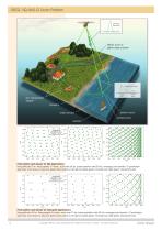
RIEGL VQ-860-G Scan Pattern transmitted laser pulse elliptic scan of green laser scanner received echo signal surface echo bottom echo shoreline bottom echo water surface surface echo seabed Point pattern and density for UAV applications flying altitude 75 m, flying speed 10 m/sec, scan rate 69 lps, pulse repetion rate 50 kHz, average point density: 76 points/sqm grey lines: scan trace on ground, green dots: points on the ground (dark green: forward look, light green: backward look) Point pattern and density for helicopter applications flying altitude 150 m, flying speed 26 m/sec, scan rate 77...
Open the catalog to page 2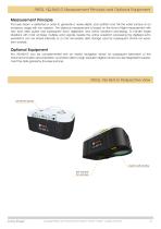
RIEGL VQ-860-G Measurement Principle and Equipment RIEGLOptional VQ-880-G Housing Measurement Principle The laser beam is deflected in order to generate a nearly elliptic scan pattern and hits the water surface at an incidence angle with low variation. The distance measurement is based on the time-of-flight measurement with very short laser pulses and subsequent echo digitization and online waveform processing. To handle target situations with most complex multiple echo signals, beside the online waveform processing the digitized echo waveforms can be stored internally or on the removable data...
Open the catalog to page 3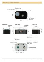
RIEGL VQ-860-G Main Dimensions Copyright RIEGL Laser Measurement Systems GmbH © 2025 – All rights reserved. Data Sheet
Open the catalog to page 4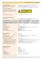
Export Classification The Topo-Bathymetric Airborne Laser Scanner VQ-860-G has been designed and developed for commercial topographic, hydrographic and bathymetric surveying applications. RIEGL VQ-860-G Technical Data The VQ-860-G is subject to export restrictions as set up by the Wassenaar Arrangement. It is classified as dual-use good according to position number 6A8j3 of the official Dual-Use-List to be found on site http://www.wassenaar.org. Within the European Union, (Regulation (EU) No. 2021/821) implements the export restrictions of the Wassenaar Arrangement. The corresponding position...
Open the catalog to page 5
RIEGL VQ-860-G Technical Data (Optional Components) IMU/GNSS (optional) IMU Accuracy 1) Roll, Pitch 0.015° Heading 0.035° IMU Sampling Rate 200 Hz Position Accuracy (typ.) horizontal / vertical <0.05 m / <0.1 m Integrated Digital Camera (optional) RGB Camera Sensor Resolution Sensor Dimensions (diagonal) Focal Length of Camera Lens Field of View (FOV) Interface Data Interfaces Configuration Scan Data Output GNSS Interface 2) General IO & Control Camera Interface Removable Storage Card Internal Data Storage 1) accuracy specifications for post-processed data 2) to be used for external GNSS receiver...
Open the catalog to page 6All RIEGL LMS catalogs and technical brochures
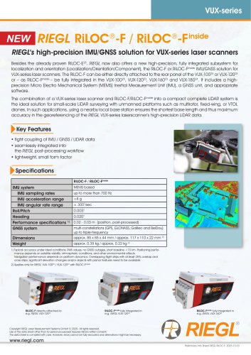 RiLOC-F / RiLOC-F-inside
1 Page
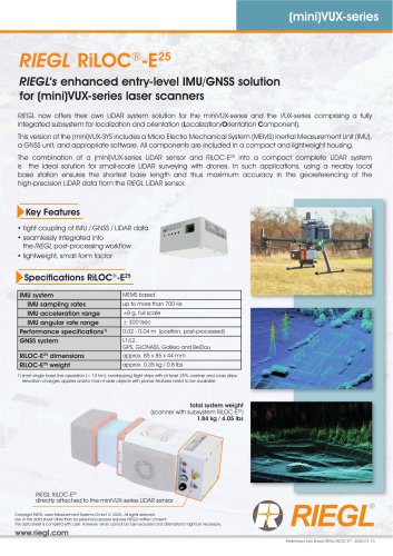 RIEGL RiLOC-E-25
1 Page
 RiACQUIRE
4 Pages
 RIEGL VMX-2HA
8 Pages
 RIEGL VZ-4000i-25
8 Pages
 RIEGL VQ-840-GL
6 Pages
 RIEGL VZ-2000i
10 Pages
 RIEGL VQX-1 Wing Pod
4 Pages
 RIEGL VQ-580 II-S
8 Pages
 RIEGL VQ-1560 III-S
10 Pages
 RIEGL VQ-1260
10 Pages
 RIEGL VQ-1460
10 Pages
 RIEGL VPX-1
2 Pages
 RIEGL Monitoring Apps
4 Pages
 RIEGL VMY-1
4 Pages
 RIEGL VQ-680
8 Pages
 RIEGL VMY-2
8 Pages
 RIEGL V-Line CB23
2 Pages
 RIEGL VMQ -1HA
6 Pages
 RIEGL LD05e-A30-PH67
5 Pages
 RIEGL VZ-600i
8 Pages
 RIEGL VZ-200
6 Pages
 RIEGL VQ-840-G
6 Pages
 RIEGL VQ-840-GE
6 Pages
 RiMINING
4 Pages
 RIEGL VUX-180-24
6 Pages
 RIEGL VUX-240-24
6 Pages
 VUX-160²³
6 Pages
 RIEGL VUX-120²³
8 Pages
 RIEGL miniVUX-3UAV
6 Pages
 RIEGL V-Line UB23
2 Pages
 RIEGL BLS Overview
1 Page
 LIS TreeAnalyzer Plugin
2 Pages
 RIEGL VZ-400i
10 Pages
 RIEGL VMX-RAIL
6 Pages
 LIS GeoTec Plugin
2 Pages
 RIEGL VQ-480 II
6 Pages
 RIEGL VMR
4 Pages
 RDBLib
2 Pages
 RiSOLVE
4 Pages
 RIEGL VQ-1560 II-S
10 Pages
 RIEGL VQ-780 II-S
8 Pages
 RIEGL VQ-780 II
8 Pages
 RIEGL LD05-A10GF
10 Pages
 LD05e-A10, LD05e-A30
4 Pages
 RIEGL VUX-240
6 Pages
 RIEGL VQ-580 II
6 Pages
 RiPROCESS
4 Pages
 RIEGL VQX-2 Helicopter Pod
4 Pages
 RIEGL ULS Overview
1 Page
 RIEGL ALS Overview
1 Page
 RIEGL VMX-2HA-BC
2 Pages
 RIEGL PH-VUX
2 Pages
 RIEGL Topo-Bathymetry
4 Pages
 RIEGL miniVUX-SYS
4 Pages
 RIEGL VUX-1UAV-22
6 Pages
 RIEGL VUX-1HA-22
4 Pages
 RIEGL VUX-1LR-22
6 Pages
 RIEGL UAV Sensors & Systems
2 Pages
 RiSCAN PRO
4 Pages
 RIEGL VUX-SYS
4 Pages
 RIEGL VZ-400i
2 Pages
 RIEGL miniVUX-1UAV
4 Pages
 RiVLib
4 Pages
 RiUNITE
4 Pages
 RIEGL VQ-1560i-DW
10 Pages
 RIEGL VMZ
4 Pages
 RIEGL VZ-6000
6 Pages
 RiPANO
4 Pages
 RIEGL DR1560i
2 Pages
 RiHYDRO
2 Pages
 RIEGL LD05e-HT
4 Pages
 RIEGL LD05-HTGF
13 Pages
 RIEGL VZ-2000i
2 Pages


Archived catalogs
 RIEGL VZ-4000
6 Pages
 RIEGL miniVUX-1LR
4 Pages
 RIEGL miniVUX-2UAV
4 Pages
 RIEGL LD05-A80
5 Pages
- 3D scanning system
- Measurement scanner
- XY scanner
- High-resolution scanner
- Compact scanner
- High-speed scanner
- High-precision scanner
- Portable scanner
- Rangefinder
- Laser rangefinder
- Scanning system
- LIDAR sensor
- Integrated scanner
- LIDAR scanner
- Mobile scanner
- Ethernet scanner
- Non-contact scanner
- Rugged scanner
- Wireless scanner