- Company
- Products
- Catalogs
- News & Trends
- Exhibitions
RIEGL VQ-840-GL
1 /6Pages

RIEGL VQ-840-GL
1 /6Pages
Catalog excerpts

Versatile Topo-Bathymetric Airborne Laser Scanner with Online Waveform Processing and Full Waveform Recording • for combined topographic and bathymetric airborne and UAV-based survey • high accuracy ranging based on echo digitization and online waveform processing with multiple-target capability • concurrent comprehensive full waveform storage for all measurements for subsequent full waveform analysis and waveform averaging tasks • high spatial resolution due to measurement rate of up to 200 kHz and high scanning speed of up to 100 scans/sec • integrated inertial navigation system (optional) • integrated digital camera (optional) • compact, lightweight and robust housing compliant with typical hatches in aircrafts and with stabilized platforms The RIEGL® VQ-840-GL is a fully integrated, compact airborne laser scanner for combined topographic and bathymetric surveying. The proven form factor and the use of very lightweight material make the VQ-840-GL suitable for integration into crewed aircraft and UAVs. VQ-840-GL offers customer specific initial system configurations and a large choice of parameter settings to enable mission tailored operation. The scanner carries out laser range measurements for high resolution surveying of underwater topography with a narrow, visible green laser beam, emitted from a pulsed laser source. Subject to clarity, at this particular wavelength the laser beam penetrates water enabling measurement of submerged targets. The distance measurement is based on the time-of-flight measurement with very short laser pulses and subsequent echo digitization and online waveform processing. To handle target situations with most complex multiple echo signals, beside the online waveform processing the digitized echo waveforms can be stored for subsequent off-line full waveform analysis. The laser beam is deflected in an elliptic scan pattern and hits the water surface at an incidence angle with low variation. The VQ-840-GL can be complemented with an inertial navigation sensor for subsequent estimation of the instrument’s location and orientation. As a further option a high-resolution digital camera can be integrated. The rugged internal mechanical structure together with the dust-tight and splash-proof housing enables long-term operation on airborne platforms. Typical applications include • coastline and shallow water mapping • surveying for hydraulic engineering • hydro-archeological-surveying • river surveying • repeated survey of water reservoirs visit our website www.riegl.com
Open the catalog to page 1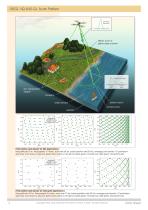
RIEGL VQ-840-GL Scan Pattern transmitted laser pulse elliptic scan of green laser scanner received echo signal surface echo bottom echo shoreline bottom echo water surface surface echo seabed Point pattern and density for UAV applications flying altitude 75 m, flying speed 10 m/sec, scan rate 69 lps, pulse repetion rate 50 kHz, average point density: 76 points/sqm grey lines: scan trace on ground, green dots: points on the ground (dark green: forward look, light green: backward look) Point pattern and density for helicopter applications flying altitude 150 m, flying speed 26 m/sec, scan rate...
Open the catalog to page 2
RIEGL VQ-840-GL Main Dimensions RIEGL VQ-880-G Housing Data Sheet Copyright RIEGL Laser Measurement Systems GmbH © 2025– All rights reserved.
Open the catalog to page 3
RIEGL VQ-840-GL Perspective View connector panel beam exit window RIEGL VQ-840-GL Installation Examples Complemented by an optional IMU/GNSS system and an optional high-resolution digital camera, the RIEGL VQ-840-GL represents a fully integrated system with low weight for integration on various aircraft platforms including UAVs. UAV integration example: RIEGL VQ-840-GL on a UAV-based platform RIEGL VQ-840-GL (with external IMU) installed on, e.g. GSM-4000 stabilized platform to be used in a helicopter or fixed-wing aircraft Copyright RIEGL Laser Measurement Systems GmbH © 2025– All rights reserved....
Open the catalog to page 4
Export Classification The Topo-Bathymetric Airborne Laser Scanner VQ-840-GL has been designed and developed for commercial topographic, hydrographic and bathymetric surveying applications. RIEGL VQ-840-GL Technical Data The VQ-840-GL is subject to export restrictions as set up by the Wassenaar Arrangement. It is classified as dual-use good according to position number 6A8j3 of the official Dual-Use-List to be found on site http://www.wassenaar.org. Within the European Union, (Regulation (EU) No. 2021/821) implements the export restrictions of the Wassenaar Arrangement. The corresponding position...
Open the catalog to page 5
Integrated Digital Camera (optional) 2) RGB Camera Sensor Resolution Sensor Dimensions (diagonal) Focal Length of Camera Lens Field of View (FOV) Data Interfaces Configuration Scan Data Output General IO & Control Camera Interface Removable Storage Card Internal Data Storage 1) accuracy specifications for post-processed data 2) Please note: adding optional features will enhance the overall weight of the system high speed data link to RIEGL DR1560ii (optional) 4) Serial RS-232 interface for data string with GNSS-time information, TTL input for 1 PPS synchronization pulse 1x TTL input/output, 1x...
Open the catalog to page 6All RIEGL LMS catalogs and technical brochures
 RiLOC-F / RiLOC-F-inside
1 Page
 RIEGL RiLOC-E-25
1 Page
 RiACQUIRE
4 Pages
 RIEGL VMX-2HA
8 Pages
 RIEGL VZ-4000i-25
8 Pages
 RIEGL VQ-860-G
6 Pages
 RIEGL VZ-2000i
10 Pages
 RIEGL VQX-1 Wing Pod
4 Pages
 RIEGL VQ-580 II-S
8 Pages
 RIEGL VQ-1560 III-S
10 Pages
 RIEGL VQ-1260
10 Pages
 RIEGL VQ-1460
10 Pages
 RIEGL VPX-1
2 Pages
 RIEGL Monitoring Apps
4 Pages
 RIEGL VMY-1
4 Pages
 RIEGL VQ-680
8 Pages
 RIEGL VMY-2
8 Pages
 RIEGL V-Line CB23
2 Pages
 RIEGL VMQ -1HA
6 Pages
 RIEGL LD05e-A30-PH67
5 Pages
 RIEGL VZ-600i
8 Pages
 RIEGL VZ-200
6 Pages
 RIEGL VQ-840-G
6 Pages
 RIEGL VQ-840-GE
6 Pages
 RiMINING
4 Pages
 RIEGL VUX-180-24
6 Pages
 RIEGL VUX-240-24
6 Pages
 VUX-160²³
6 Pages
 RIEGL VUX-120²³
8 Pages
 RIEGL miniVUX-3UAV
6 Pages
 RIEGL V-Line UB23
2 Pages
 RIEGL BLS Overview
1 Page
 LIS TreeAnalyzer Plugin
2 Pages
 RIEGL VZ-400i
10 Pages
 RIEGL VMX-RAIL
6 Pages
 LIS GeoTec Plugin
2 Pages
 RIEGL VQ-480 II
6 Pages
 RIEGL VMR
4 Pages
 RDBLib
2 Pages
 RiSOLVE
4 Pages
 RIEGL VQ-1560 II-S
10 Pages
 RIEGL VQ-780 II-S
8 Pages
 RIEGL VQ-780 II
8 Pages
 RIEGL LD05-A10GF
10 Pages
 LD05e-A10, LD05e-A30
4 Pages
 RIEGL VUX-240
6 Pages
 RIEGL VQ-580 II
6 Pages
 RiPROCESS
4 Pages
 RIEGL VQX-2 Helicopter Pod
4 Pages
 RIEGL ULS Overview
1 Page
 RIEGL ALS Overview
1 Page
 RIEGL VMX-2HA-BC
2 Pages
 RIEGL PH-VUX
2 Pages
 RIEGL Topo-Bathymetry
4 Pages
 RIEGL miniVUX-SYS
4 Pages
 RIEGL VUX-1UAV-22
6 Pages
 RIEGL VUX-1HA-22
4 Pages
 RIEGL VUX-1LR-22
6 Pages
 RIEGL UAV Sensors & Systems
2 Pages
 RiSCAN PRO
4 Pages
 RIEGL VUX-SYS
4 Pages
 RIEGL VZ-400i
2 Pages
 RIEGL miniVUX-1UAV
4 Pages
 RiVLib
4 Pages
 RiUNITE
4 Pages
 RIEGL VQ-1560i-DW
10 Pages
 RIEGL VMZ
4 Pages
 RIEGL VZ-6000
6 Pages
 RiPANO
4 Pages
 RIEGL DR1560i
2 Pages
 RiHYDRO
2 Pages
 RIEGL LD05e-HT
4 Pages
 RIEGL LD05-HTGF
13 Pages
 RIEGL VZ-2000i
2 Pages


Archived catalogs
 RIEGL VZ-4000
6 Pages
 RIEGL miniVUX-1LR
4 Pages
 RIEGL miniVUX-2UAV
4 Pages
 RIEGL LD05-A80
5 Pages
- 3D scanning system
- Measurement scanner
- XY scanner
- High-resolution scanner
- Compact scanner
- High-speed scanner
- High-precision scanner
- Portable scanner
- Rangefinder
- Laser rangefinder
- Scanning system
- LIDAR sensor
- Integrated scanner
- LIDAR scanner
- Mobile scanner
- Ethernet scanner
- Non-contact scanner
- Rugged scanner
- Wireless scanner