- Company
- Products
- Catalogs
- News & Trends
- Exhibitions
RIEGL VQ-580 II-S
1 /8Pages

RIEGL VQ-580 II-S
1 /8Pages
Catalog excerpts

S ‘ Waveform Processing Airborne Laser Scanning System mm£ with Increased Range Capacity • increased measurement range of up to 2.450 m • high accuracy ranging based on RIEGL Waveform-LiDAR technology • high laser pulse repetition rate up to 2 MHz • measurement rate up to 1,250,000 measurements/sec • perfectly linear and parallel scan lines • wide field of view of 75° • excellently suited • interfaces for up to 5 optional cameras • mechanical and electrical interface for IMU/GNSS integration • removeable storage card and integrated solid state drive (SSD) for data storage • compact and lightweight design • compatible with stabilized platforms and even small hatches • seamless integration and compatibility with other RIEGL ALS systems and software packages To meet the increasing requirements of compact laser scanners for medium- and wide-area mapping as well as for corridor mapping, RIEGL offers the VQ-580 II-S, which provides an increased maximum measurement range of up to 2.450 m. It is perfectly suited for integration with gyro-stabilized mounts as well as into the VQX-1 Wing Pod, RIEGL’s fully integrated laser scanning system for user-friendly installation on Cessna single piston engine aircraft to facilitate various airborne mapping applications. Based on RIEGL's proven Waveform-LiDAR technology, the VQ-580 II-S provides highly accurate and precise point clouds, excellent vertical target resolution, calibrated reflectance readings, and pulse shape deviation for unsurpassed information content on each single measurement. With a measurement rate of up to 1,250,000 meas./sec and an extremely wide field of view of 75 degrees, the versatile instrument perfectly meets the challenges in various special airborne surveying applications - from corridor mapping to forestry - from a wide range of manned aircraft such as helicopters, small fixed wing aircraft and ultralight aircraft. Due to the laser wavelength used, the system enables measurements to wet and frozen surfaces and delivers first class results in snowfield mapping and glacier monitoring. The RIEGL VQ-580 II-S provides mechanical and electrical interfaces for the integration with an appropriate IMU/GNSS unit and is ready for controlling up to 5 optional cameras. Convenient access to the acquired scan data is ensured by data storage on an easy to remove CFast® storage card and an integrated solid state drive, but also by streaming scan data via a LAN TCP/IP interface. Typical applications include • Medium to Wide Area Mapping • Corridor Mapping • City Modeling • Glacier and Snowfield Monitoring • Agriculture & Forestry visit our website www, riegl.com RIEGIl LASER MEASUREMENT SYSTEMS Airborne Laser Scanning
Open the catalog to page 1
Dimensional Drawings RIEGL VQ®-580 II-S cooling air outlet Front View Side View Rear View connector panel connector panel RIEGL VQ-580II-S installed on GSM-5000 stabilized platform 2 Copyright RIEGL Laser Measurement Systems GmbH © 2025 - All rights reserved. Data Sheet
Open the catalog to page 2
Maximum Measurement Range & Point Density RIEGL VQ®-580 II-S Laser 4500 Pulse Repetition Rate = 300kHz, laser power level 100% 3320 10890 3130 Typical ENOHD dry snow white plaster work, limestone deciduous trees cliffs, sand, masonry Operating Flight Altitude [m] visibility 23 km visibility 15 km visibility 8 km terra cotta Target Reflectance [%] Operating Flight Altitude [ft] Example: VQ-580 II-S at 300,000 pulses/sec, laser power level 100% altitude 7,700 ft AGL, speed 120 kn point density ~ 0.8 pts/m² area acquisition rate ~ 683 km²/h point density ~ 2.2 pts/m² area acquisition rate ~ 515...
Open the catalog to page 3
Maximum Measurement Range & Point Density RIEGL VQ®-580 II-S Laser Pulse Repetition Rate = 2000kHz, laser power level 100% 2200 1620 5320 visibility 23 km visibility 15 km visibility 8 km cliffs, sand, masonry terra cotta deciduous trees Target Reflectance [%] Operating Flight Altitude [ft] Typical ENOHD Operating Flight Altitude [m] dry snow white plaster work, limestone Example: VQ-580 II-S at 2,000,000 pulses/sec, laser power level 100% altitude 3,400 ft AGL, speed 120 kn point density ~ 12.73 pts/m² area acquisition rate ~ 302 km²/h point density ~ 16.7 pts/m² area acquisition rate ~ 231...
Open the catalog to page 4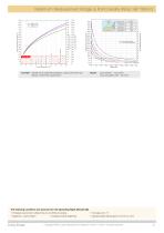
Maximum Measurement Range & Point Density RIEGL VQ®-580 II-S Laser Pulse Repetition Rate = 2000kHz, laser power level 12% 900 660 2180 630 dry snow white plaster work, limestone deciduous trees cliffs, sand, masonry terra cotta Typical ENOHD Target Reflectance [%] Operating Flight Altitude [m] visibility 23 km visibility 15 km visibility 8 km Operating Flight Altitude [ft] Example: VQ-580 II-S at 2,000,000 pulses/sec, laser power level 12% altitude 1,200 ft AGL, speed 60 kn point density ~ 72.2 pts/m² area acquisition rate ~ 53 km²/h The following conditions are assumed for the Operating Flight...
Open the catalog to page 5
Laser Product Classification Class 3B Laser Product according to IEC 60825-1:2014 Measuring Principle The following clause applies for instruments delivered into the United States: Complies with 21 CFR 1040.10 and 1040.11 except for conformance with IEC 60825-1 Ed.3., as described in Laser Notice No. 56, dated May 8, 2019. The instrument must be used only in combination with the appropriate laser safety box. echo signal digitization, online waveform processing, time-of-flight measurement, multiple target capability Laser Pulse Repetition Rate PRR 1) Laser Power Level 2) Typical values for average...
Open the catalog to page 6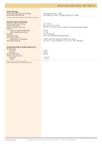
Permanently Installed Data Storage SSD, 2 TByte Removable Data Storage Cardholder for CFAST® 1) storage cards (up to 1 TByte) 1) CFast is a registered trademark of CompactFlash Association. General Technical Data Power Supply Input Voltage Power Consumption Main Dimensions (L x W x H) Weight without integrated IMU/GNSS with integrated IMU/GNSS Humidity Protection Class Max. Flight Altitude operating & not operating Temperature Range 378 mm x 193 mm x 252 mm (without mounted carrying handles) 18500 ft (5600 m) above MSL (Mean Sea Level) Integrated IMU & GNSS (optional) 3) 2) Max. scan rate, all...
Open the catalog to page 7All RIEGL LMS catalogs and technical brochures
 RiLOC-F / RiLOC-F-inside
1 Page
 RIEGL RiLOC-E-25
1 Page
 RiACQUIRE
4 Pages
 RIEGL VMX-2HA
8 Pages
 RIEGL VZ-4000i-25
8 Pages
 RIEGL VQ-860-G
6 Pages
 RIEGL VQ-840-GL
6 Pages
 RIEGL VZ-2000i
10 Pages
 RIEGL VQX-1 Wing Pod
4 Pages
 RIEGL VQ-1560 III-S
10 Pages
 RIEGL VQ-1260
10 Pages
 RIEGL VQ-1460
10 Pages
 RIEGL VPX-1
2 Pages
 RIEGL Monitoring Apps
4 Pages
 RIEGL VMY-1
4 Pages
 RIEGL VQ-680
8 Pages
 RIEGL VMY-2
8 Pages
 RIEGL V-Line CB23
2 Pages
 RIEGL VMQ -1HA
6 Pages
 RIEGL LD05e-A30-PH67
5 Pages
 RIEGL VZ-600i
8 Pages
 RIEGL VZ-200
6 Pages
 RIEGL VQ-840-G
6 Pages
 RIEGL VQ-840-GE
6 Pages
 RiMINING
4 Pages
 RIEGL VUX-180-24
6 Pages
 RIEGL VUX-240-24
6 Pages
 VUX-160²³
6 Pages
 RIEGL VUX-120²³
8 Pages
 RIEGL miniVUX-3UAV
6 Pages
 RIEGL V-Line UB23
2 Pages
 RIEGL BLS Overview
1 Page
 LIS TreeAnalyzer Plugin
2 Pages
 RIEGL VZ-400i
10 Pages
 RIEGL VMX-RAIL
6 Pages
 LIS GeoTec Plugin
2 Pages
 RIEGL VQ-480 II
6 Pages
 RIEGL VMR
4 Pages
 RDBLib
2 Pages
 RiSOLVE
4 Pages
 RIEGL VQ-1560 II-S
10 Pages
 RIEGL VQ-780 II-S
8 Pages
 RIEGL VQ-780 II
8 Pages
 RIEGL LD05-A10GF
10 Pages
 LD05e-A10, LD05e-A30
4 Pages
 RIEGL VUX-240
6 Pages
 RIEGL VQ-580 II
6 Pages
 RiPROCESS
4 Pages
 RIEGL VQX-2 Helicopter Pod
4 Pages
 RIEGL ULS Overview
1 Page
 RIEGL ALS Overview
1 Page
 RIEGL VMX-2HA-BC
2 Pages
 RIEGL PH-VUX
2 Pages
 RIEGL Topo-Bathymetry
4 Pages
 RIEGL miniVUX-SYS
4 Pages
 RIEGL VUX-1UAV-22
6 Pages
 RIEGL VUX-1HA-22
4 Pages
 RIEGL VUX-1LR-22
6 Pages
 RIEGL UAV Sensors & Systems
2 Pages
 RiSCAN PRO
4 Pages
 RIEGL VUX-SYS
4 Pages
 RIEGL VZ-400i
2 Pages
 RIEGL miniVUX-1UAV
4 Pages
 RiVLib
4 Pages
 RiUNITE
4 Pages
 RIEGL VQ-1560i-DW
10 Pages
 RIEGL VMZ
4 Pages
 RIEGL VZ-6000
6 Pages
 RiPANO
4 Pages
 RIEGL DR1560i
2 Pages
 RiHYDRO
2 Pages
 RIEGL LD05e-HT
4 Pages
 RIEGL LD05-HTGF
13 Pages
 RIEGL VZ-2000i
2 Pages


Archived catalogs
 RIEGL VZ-4000
6 Pages
 RIEGL miniVUX-1LR
4 Pages
 RIEGL miniVUX-2UAV
4 Pages
 RIEGL LD05-A80
5 Pages