 Website:
RIEGL LMS
Catalog excerpts

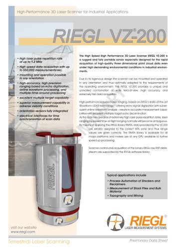
Waveform Processing Airborne LiDAR Scanning System for High Point Density Mapping and Ultra-Wide Area Mapping • high pulse repetition rates of up to 4.4 MHz • up to 2.93 million measurements per second on the ground • best point distribution for optimum target resolution • excellent atmospheric clutter suppression • multiple target capability • online waveform processing and full waveform data recording • on-board graphical user interface for easy access to primary scanner parameters • integrated inertial measurement unit and GNSS receiver • prepared for the integration of up to two high resolution RGB/NIR cameras • optimized for interfacing with typical hatches and stabilized platforms • deteachable handgrips for facilitated handling The VQ-1460 is one of RIEGL‘s latest high-end airborne laser scanning systems, suitable for a wide field of applications – from high-point density wide area mapping to ultra-high resolution city mapping or corridor mapping. The unique design features pulse repetition rates from 4.4 MHz, resulting in a regular point spacing and an almost constant point density distribution on the ground. For a target reflectance of 20 %, the system features large measurement distances of up to 5400 m at a minimum PRR of 540 kHz and of up to 2300 m at a maximum PRR of 4.4 MHz, resulting in an unsurpassed high efficiency in area acquisition of e.g., up to 615 km²/h at 150 knots flying speed for an average of 8 points per square meter. A newly designed optical fronted significantly minimizes for near-range echoes due to atmospheric clutter, resulting in clean point clouds. Online-Waveform processing and full-waveform processing capabilities are a matter of course for this class of equipment. Scan data and camera images are stored on removable hard disks that can be accessed directly on the device, eliminating the need for an external data recorder. A high-performance IMU/GNSS unit and one or two optional highresolution RGB/NIR cameras are seamlessly integrated in the compact and user-friendly designed housing. The standardized mounting flange fits typical hatches or gyro-stabilized leveling mounts for maintaining optimum point distribution. Applications: • Ultra Wide Area / High Altitude Mapping • Ultra-High Point Density Mapping • Mapping of Complex Urban Environments • Glacier & Snowfield Mapping • City Modeling • Mapping of Lakesides & River Banks • Agriculture & Forestry • Corridor Mapping visit our website www.riegl
Open the catalog to page 1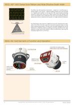
RIEGL VQ®-1460 Dense Scan Pattern and Wide Effective Swath Width The RIEGL VQ-1460 scanning mechanism – based on a continuously rotating polygon mirror wheel – delivers straight parallel scan lines resulting in a regular point pattern on the ground. With equal spatial sampling frequency along and across track, object extents are well defined and even small objects may be detected. The instrument is perfectly suited for applications where a superior point pattern on target surfaces is required. RIEGL VQ-1460 point distribution The wide field of view and the multiple-time-around measurement...
Open the catalog to page 2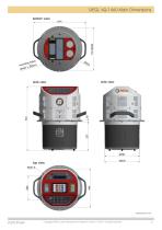
RIEGL VQ-1460 Main Dimensions Data Sheet Copyright RIEGL Laser Measurement Systems GmbH © 2024– All rights reserved.
Open the catalog to page 3
RIEGL VQ-1460 System Components A minimum number of system components and external cabling is required for an easy and quick installation in aircrafts. RIEGL VQ-1460 installed on GSM-4000 gyro-stabilized platform to be used in a helicopter or fixed-wing aircraft RIEGL VQ-1460 installed in the fuselage hatch of the Diamond Aircraft DA62 Survey Star Copyright RIEGL Laser Measurement Systems GmbH © 2024– All rights reserved. Data Sheet
Open the catalog to page 4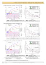
Measurement Range & Point Density RIEGL VQ-1460 Laser Pulse Repetition Rate = 2x270kHz, laser power level 100% 7370 deciduous trees cliffs, sand, masonry dry snow white plaster work, limestone terra cotta Operating Flight Altitude [m] visibility 40 km visibility 23 km visibility 15 km Target Reflectance [%] Operating Flight Altitude [ft] Example: VQ-1460 at 2 x 270,000 pulses/sec, laser power level 100% altitude 12,000 ft AGL, speed 160 kn point density ~ 1.04 pts/m² area acquisition rate ~ 1001 km²/h point density ~ 2.35 pts/m² area acquisition rate ~ 818 km²/h point density ~ 13.13 pts/m²...
Open the catalog to page 5
Measurement Range & Point Density RIEGL VQ-1460 Laser Pulse Repetition Rate = 2x2200kHz, laser power level 100% 3480 terra cotta dry snow white plaster work, limestone cliffs, sand, masonry deciduous trees coniferous trees Target Reflectance [%] Operating Flight Altitude [m] visibility 40 km visibility 23 km visibility 15 km Operating Flight Altitude [ft] Example: VQ-1460 at 2 x 2,200,000 pulses/sec, laser power level 100% altitude 5,800 ft AGL, speed 170 kn point density ~ 16.43 pts/m² area acquisition rate ~ 514 km²/h point density ~ 19.29 pts/m² area acquisition rate ~ 438 km²/h point...
Open the catalog to page 6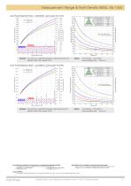
Measurement Range & Point Density RIEGL VQ-1460 Laser Pulse Repetition Rate = 2x2200kHz, laser power level 12% 4560 dry snow white plaster work, limestone cliffs, sand, masonry deciduous trees coniferous trees terra cotta Target Reflectance [%] Operating Flight Altitude [ft] 1390 visibility 40 km visibility 23 km visibility 15 km Operating Flight Altitude [m] Example: VQ-1460 at 2 x 2,200,000 pulses/sec, laser power level 12% altitude 2,800 ft AGL, speed 115 kn point density ~ 50.31 pts/m² area acquisition rate ~ 168 km²/h point density ~ 57.86 pts/m² area acquisition rate ~ 146 km²/h Laser...
Open the catalog to page 7
RIEGL VQ-1460 Productivity The RIEGL VQ-1460 Waveform Processing Airborne LiDAR Mapping System offers highest productivity. Examples 1) Average Point Density Flight Altitude Ground Speed Swath Width Productivity eff. Measurement Rate Camera GSD Camera Trigger Intervall 1) calculated for 20% target reflectivity and 20% stripe overlap 2) The target detection rate is equal to the measurement rate for terrains offering only one target per laser pulse but may be much higher for vegetated areas. 3) Ground Sampling Distance 4) calculated for a 150 MPixel CMOS camera with a FOV of 56.2° x 43.7° and...
Open the catalog to page 8All RIEGL LMS catalogs and technical brochures
-
RIEGL VPX-1
2 Pages
-
RIEGL VQ-1560 III-S
10 Pages
-
RIEGL VMY-2
8 Pages
-
RIEGL V-Line CB23
2 Pages
-
RIEGL VMQ -1HA
6 Pages
-
RIEGL LD05e-A30-PH67
5 Pages
-
RIEGL VZ-600i
8 Pages
-
RIEGL VZ-200
6 Pages
-
RIEGL RiLOC-E-25
1 Pages
-
RiLOC-F - Preliminary
1 Pages
-
RIEGL VQ-580 II-S
8 Pages
-
RIEGL VQ-680
8 Pages
-
RIEGL VQ-860-G
6 Pages
-
RIEGL VQ-1260
10 Pages
-
RIEGL VZ-4000i-25
8 Pages
-
RIEGL VQ-840-GL
6 Pages
-
RIEGL VQ-840-G
6 Pages
-
RIEGL VQ-840-GE
6 Pages
-
RIEGL VMX-2HA
8 Pages
-
RiMINING
4 Pages
-
RIEGL VUX-180-24
6 Pages
-
RIEGL VUX-240-24
6 Pages
-
VUX-160²³
6 Pages
-
RIEGL VUX-120²³
8 Pages
-
RIEGL miniVUX-3UAV
6 Pages
-
RIEGL V-Line UB23
2 Pages
-
RIEGL Mobile Mapping Systems
1 Pages
-
RIEGL BLS Overview
1 Pages
-
LIS TreeAnalyzer Plugin
2 Pages
-
RIEGL VZ-2000i
10 Pages
-
RIEGL VZ-400i
10 Pages
-
RIEGL Monitoring Apps
2 Pages
-
RIEGL VMX-RAIL
6 Pages
-
RIEGL VQX-1 Wing Pod
4 Pages
-
LIS GeoTec Plugin
2 Pages
-
RIEGL VQ-480 II
6 Pages
-
RIEGL VMY-1
4 Pages
-
RIEGL VMR
4 Pages
-
RDBLib
2 Pages
-
RiSOLVE
4 Pages
-
RIEGL VQ-1560 II-S
10 Pages
-
RIEGL VQ-780 II-S
8 Pages
-
RIEGL VQ-780 II
8 Pages
-
RIEGL LD05-A10GF
10 Pages
-
LD05e-A10, LD05e-A30
4 Pages
-
RIEGL VUX-240
6 Pages
-
RIEGL VQ-580 II
6 Pages
-
RiPROCESS
4 Pages
-
RIEGL VQX-2 Helicopter Pod
4 Pages
-
RIEGL ULS Overview
1 Pages
-
RIEGL ALS Overview
1 Pages
-
RIEGL VMX-2HA-BC
2 Pages
-
RIEGL PH-VUX
2 Pages
-
RIEGL Topo-Bathymetry
4 Pages
-
RIEGL miniVUX-SYS
4 Pages
-
RIEGL VUX-1UAV-22
6 Pages
-
RIEGL VUX-1HA-22
4 Pages
-
RIEGL VUX-1LR-22
6 Pages
-
RIEGL UAV Sensors & Systems
2 Pages
-
RiSCAN PRO
4 Pages
-
RIEGL VUX-SYS
4 Pages
-
RIEGL VZ-400i
2 Pages
-
RIEGL miniVUX-1UAV
4 Pages
-
RiVLib
4 Pages
-
RiACQUIRE
4 Pages
-
RiUNITE
4 Pages
-
RIEGL VQ-1560i-DW
10 Pages
-
RIEGL VMZ
4 Pages
-
RIEGL VZ-6000
6 Pages
-
RiPANO
4 Pages
-
RIEGL DR1560i
2 Pages
-
RiHYDRO
2 Pages
-
RIEGL LD05e-HT
4 Pages
-
RIEGL LD05-HTGF
13 Pages
-
RIEGL VZ-2000i
2 Pages
Archived catalogs
-
RIEGL miniVUX-1LR
4 Pages
-
RIEGL miniVUX-2UAV
4 Pages
-
RIEGL VZ-4000
6 Pages
-
RIEGL LD05-A80
5 Pages


