- Company
- Products
- Catalogs
- News & Trends
- Exhibitions
RIEGL Topo-Bathymetry
1 /4Pages

RIEGL Topo-Bathymetry
1 /4Pages
Catalog excerpts

RIEGL LiDAR TECHNOLOGY for Airborne Topo-Bathymetry Château d’If, Marseille, France: 3D topo-bathymetric data acquired with RIEGL VQ-840-G Where water meets land, changes take place. Close monitoring of these is a necessity. In shallow water, however, surveying from a boat becomes a challenge. This is where Airborne Lidar Bathymetry (ALB) is of significant advantage. The strengths of LiDAR technology in a hydrographic context are the collection of seamless data sets that span the land/water interface, enabling high-resolution surveying of both above and below water surface topology with high efficiency. DISCOVER RIEGL TOPO-BATHYMETRICS SENSORS & SYSTEMS ‘s data sheet Extra lightweight topo-bathymetric airborne laser scanner for integration on UAVs data sheet Topo-Bathymetric airborne laser scanner for integration on UAVs or helicopters data sheet Highly efficient, fully integrated topobathymetric airborne laser scanning system with compact form factor for helicopters data sheet Highly efficient, fully integrated topo-bathymetric airborne laser scanning system for use in fixed wing aircraft, compatible with stabilizing mo
Open the catalog to page 1
Coastal Mapping Efficiency for wide areas ... ALB is the technology of choice for surveying shallow water zones in coastal areas. In a single data acquisition mission both terrestrial and submarine topography of a shoreline are covered. RIEGL provides several topo-bathymetric system models for integration with crewed fixed-wing aircraft and helicopters. These sophisticated dual channel systems employ multiple laser wavelengths to improve ranging performance, depth penetration and enhance resolution of targets above and below the water surface. Subject to water turbidity and bottom reflectance...
Open the catalog to page 2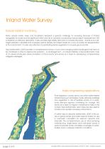
Inland Water Survey Natural habitat monitoring Rivers, alluvial forests, lakes, and floodplains represent a special challenge for surveying because of limited navigability for boats and the significant effort and risk to surveyors conducting manual depth measurement. ALB is therefore an effective alternative. It also provides high-fidelity data sets of complex structures – thanks to its multitarget-resolution capability that increases vertical density and object detail for a very accurate 3D representation of the environment. It is also very effective at penetrating dense vegetation to acquire...
Open the catalog to page 3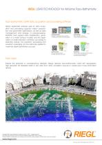
RIEGL LiDAR TECHNOLOGY for Airborne Topo-Bathymetry Topo-bathymetric LiDAR data acquisition and processing software RiACQUIRE RIEGL’s dedicated software suite for data acquisition and processing supports mission preparation and parameter optimization, as well as data management and storage. In post-processing, RiHYDRO tools support data classification, generation of a water surface models, and the application of water refraction correction according to refraction indices. Full waveform processing and waveform averaging can be optionally applied to maximize depth penetration success. Requirements...
Open the catalog to page 4All RIEGL LMS catalogs and technical brochures
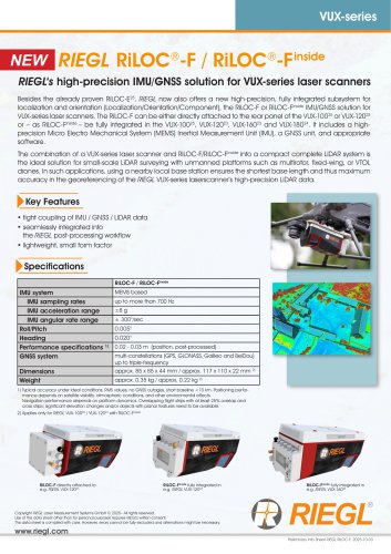 RiLOC-F / RiLOC-F-inside
1 Page
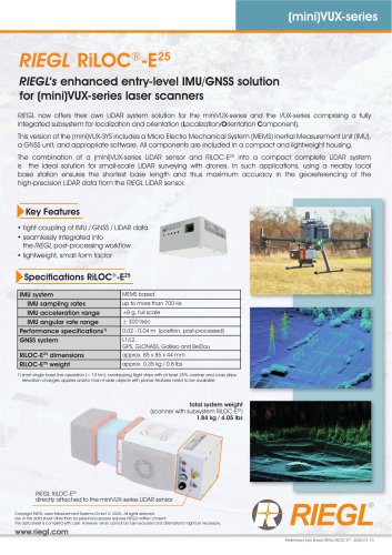 RIEGL RiLOC-E-25
1 Page
 RiACQUIRE
4 Pages
 RIEGL VMX-2HA
8 Pages
 RIEGL VZ-4000i-25
8 Pages
 RIEGL VQ-860-G
6 Pages
 RIEGL VQ-840-GL
6 Pages
 RIEGL VZ-2000i
10 Pages
 RIEGL VQX-1 Wing Pod
4 Pages
 RIEGL VQ-580 II-S
8 Pages
 RIEGL VQ-1560 III-S
10 Pages
 RIEGL VQ-1260
10 Pages
 RIEGL VQ-1460
10 Pages
 RIEGL VPX-1
2 Pages
 RIEGL Monitoring Apps
4 Pages
 RIEGL VMY-1
4 Pages
 RIEGL VQ-680
8 Pages
 RIEGL VMY-2
8 Pages
 RIEGL V-Line CB23
2 Pages
 RIEGL VMQ -1HA
6 Pages
 RIEGL LD05e-A30-PH67
5 Pages
 RIEGL VZ-600i
8 Pages
 RIEGL VZ-200
6 Pages
 RIEGL VQ-840-G
6 Pages
 RIEGL VQ-840-GE
6 Pages
 RiMINING
4 Pages
 RIEGL VUX-180-24
6 Pages
 RIEGL VUX-240-24
6 Pages
 VUX-160²³
6 Pages
 RIEGL VUX-120²³
8 Pages
 RIEGL miniVUX-3UAV
6 Pages
 RIEGL V-Line UB23
2 Pages
 RIEGL BLS Overview
1 Page
 LIS TreeAnalyzer Plugin
2 Pages
 RIEGL VZ-400i
10 Pages
 RIEGL VMX-RAIL
6 Pages
 LIS GeoTec Plugin
2 Pages
 RIEGL VQ-480 II
6 Pages
 RIEGL VMR
4 Pages
 RDBLib
2 Pages
 RiSOLVE
4 Pages
 RIEGL VQ-1560 II-S
10 Pages
 RIEGL VQ-780 II-S
8 Pages
 RIEGL VQ-780 II
8 Pages
 RIEGL LD05-A10GF
10 Pages
 LD05e-A10, LD05e-A30
4 Pages
 RIEGL VUX-240
6 Pages
 RIEGL VQ-580 II
6 Pages
 RiPROCESS
4 Pages
 RIEGL VQX-2 Helicopter Pod
4 Pages
 RIEGL ULS Overview
1 Page
 RIEGL ALS Overview
1 Page
 RIEGL VMX-2HA-BC
2 Pages
 RIEGL PH-VUX
2 Pages
 RIEGL miniVUX-SYS
4 Pages
 RIEGL VUX-1UAV-22
6 Pages
 RIEGL VUX-1HA-22
4 Pages
 RIEGL VUX-1LR-22
6 Pages
 RIEGL UAV Sensors & Systems
2 Pages
 RiSCAN PRO
4 Pages
 RIEGL VUX-SYS
4 Pages
 RIEGL VZ-400i
2 Pages
 RIEGL miniVUX-1UAV
4 Pages
 RiVLib
4 Pages
 RiUNITE
4 Pages
 RIEGL VQ-1560i-DW
10 Pages
 RIEGL VMZ
4 Pages
 RIEGL VZ-6000
6 Pages
 RiPANO
4 Pages
 RIEGL DR1560i
2 Pages
 RiHYDRO
2 Pages
 RIEGL LD05e-HT
4 Pages
 RIEGL LD05-HTGF
13 Pages
 RIEGL VZ-2000i
2 Pages


Archived catalogs
 RIEGL VZ-4000
6 Pages
 RIEGL miniVUX-1LR
4 Pages
 RIEGL miniVUX-2UAV
4 Pages
 RIEGL LD05-A80
5 Pages