- Company
- Products
- Catalogs
- News & Trends
- Exhibitions
LIS GeoTec Plugin
1 /2Pages

LIS GeoTec Plugin
1 /2Pages
Catalog excerpts
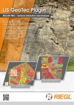
LIS GeoTec Plugin RiSCAN PRO – Surface Extraction and Analysis The LIS GeoTec software tool is a RiSCAN PRO Plugin for geotechnical analysis of scanned rock surfaces. It facilitates the calculation of surface normals for a local neighborhood. These surface normals are further analyzed to detect clusters of pre-dominant surface orientations, which are used for data classification and visualization on a polarplot diagram. DETAILED ANALYSIS GEOLOGY
Open the catalog to page 1
Geotechnical Analysis Surface Normals Surface normals are extracted with respect to a local neighborhood. For every measured point a user defined number of neighboring points is analyzed to calculate a best fit plane. The surface normal of the plane represents the point surface normal. All further analysis is based on the point surface normal attribute. Analysis Visualization Dip and dip direction angles are calculated with respect to a given coordinate reference system. Dip is the vertical angle of the surface with a horizontal intersecting plane. Dip direction is the angle of the horizontal...
Open the catalog to page 2All RIEGL LMS catalogs and technical brochures
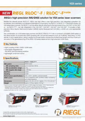 RiLOC-F / RiLOC-F-inside
1 Page
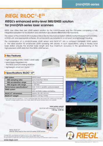 RIEGL RiLOC-E-25
1 Page
 RiACQUIRE
4 Pages
 RIEGL VMX-2HA
8 Pages
 RIEGL VZ-4000i-25
8 Pages
 RIEGL VQ-860-G
6 Pages
 RIEGL VQ-840-GL
6 Pages
 RIEGL VZ-2000i
10 Pages
 RIEGL VQX-1 Wing Pod
4 Pages
 RIEGL VQ-580 II-S
8 Pages
 RIEGL VQ-1560 III-S
10 Pages
 RIEGL VQ-1260
10 Pages
 RIEGL VQ-1460
10 Pages
 RIEGL VPX-1
2 Pages
 RIEGL Monitoring Apps
4 Pages
 RIEGL VMY-1
4 Pages
 RIEGL VQ-680
8 Pages
 RIEGL VMY-2
8 Pages
 RIEGL V-Line CB23
2 Pages
 RIEGL VMQ -1HA
6 Pages
 RIEGL LD05e-A30-PH67
5 Pages
 RIEGL VZ-600i
8 Pages
 RIEGL VZ-200
6 Pages
 RIEGL VQ-840-G
6 Pages
 RIEGL VQ-840-GE
6 Pages
 RiMINING
4 Pages
 RIEGL VUX-180-24
6 Pages
 RIEGL VUX-240-24
6 Pages
 VUX-160²³
6 Pages
 RIEGL VUX-120²³
8 Pages
 RIEGL miniVUX-3UAV
6 Pages
 RIEGL V-Line UB23
2 Pages
 RIEGL BLS Overview
1 Page
 LIS TreeAnalyzer Plugin
2 Pages
 RIEGL VZ-400i
10 Pages
 RIEGL VMX-RAIL
6 Pages
 RIEGL VQ-480 II
6 Pages
 RIEGL VMR
4 Pages
 RDBLib
2 Pages
 RiSOLVE
4 Pages
 RIEGL VQ-1560 II-S
10 Pages
 RIEGL VQ-780 II-S
8 Pages
 RIEGL VQ-780 II
8 Pages
 RIEGL LD05-A10GF
10 Pages
 LD05e-A10, LD05e-A30
4 Pages
 RIEGL VUX-240
6 Pages
 RIEGL VQ-580 II
6 Pages
 RiPROCESS
4 Pages
 RIEGL VQX-2 Helicopter Pod
4 Pages
 RIEGL ULS Overview
1 Page
 RIEGL ALS Overview
1 Page
 RIEGL VMX-2HA-BC
2 Pages
 RIEGL PH-VUX
2 Pages
 RIEGL Topo-Bathymetry
4 Pages
 RIEGL miniVUX-SYS
4 Pages
 RIEGL VUX-1UAV-22
6 Pages
 RIEGL VUX-1HA-22
4 Pages
 RIEGL VUX-1LR-22
6 Pages
 RIEGL UAV Sensors & Systems
2 Pages
 RiSCAN PRO
4 Pages
 RIEGL VUX-SYS
4 Pages
 RIEGL VZ-400i
2 Pages
 RIEGL miniVUX-1UAV
4 Pages
 RiVLib
4 Pages
 RiUNITE
4 Pages
 RIEGL VQ-1560i-DW
10 Pages
 RIEGL VMZ
4 Pages
 RIEGL VZ-6000
6 Pages
 RiPANO
4 Pages
 RIEGL DR1560i
2 Pages
 RiHYDRO
2 Pages
 RIEGL LD05e-HT
4 Pages
 RIEGL LD05-HTGF
13 Pages
 RIEGL VZ-2000i
2 Pages


Archived catalogs
 RIEGL VZ-4000
6 Pages
 RIEGL miniVUX-1LR
4 Pages
 RIEGL miniVUX-2UAV
4 Pages
 RIEGL LD05-A80
5 Pages
- 3D scanning system
- Laser scanner
- Measurement scanner
- XY scanner
- High-resolution scanner
- Compact scanner
- High-speed scanner
- High-precision scanner
- Portable scanner
- Scanning system
- Rangefinder
- Laser rangefinder
- LIDAR sensor
- Integrated scanner
- LIDAR scanner
- Mobile scanner
- Ethernet scanner
- Non-contact scanner
- Rugged scanner
- Wireless scanner