- Company
- Products
- Catalogs
- News & Trends
- Exhibitions
Applicationsheet Forestry & Agriculture
1 /4Pages

Applicationsheet Forestry & Agriculture
1 /4Pages
Catalog excerpts

RIEGL LiDAR in Forestry & Precision Agriculture Various LiDAR Sensors & Systems for Most Challenging Projects Based on innovative and proprietary Waveform-LiDAR technology RIEGL laser scanners and systems provide an outstanding high-density point cloud ideally suited for applications in forestry and precision agriculture. Advanced processing algorithms account for a full exploitation of the information included in scan data. Multi-target capability enables excellent vegetation penetration and the computing of detailed terrain models. Point classification is the basis for growth monitoring, height modeling, or the detection of deadfall. WAVEFORM-LiDAR TECHNOLOGY RIEGL VQ-1260 / VQ-1460 RIEGL VQ-1560i-DW / VQ-1560 II-S Airborne LiDAR Scanning Systems for High-Point Density Mapping Applications RIEGL UAS-based LiDAR Sensors for integration in the RiCOPTER and various types of renowned UAVs RIEGL VQ-480 II / VQ-580 II-S Airborne Laser Scanning Systems for use in small aircrafts, helicopters, or large UAVs RIEGL VZ-400i / VZ-600i High Performance 3D Terrestrial La
Open the catalog to page 1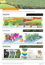
Forestry Applications Data Acquisition using Airborne, UAV-based, and Terrestrial Laser Scanning vegetation mask green: areas of vegetation higher than 3m and larger than 10 sqm canopy model vegetation colored by height above ground single tree deliniation colors represent the area covered by a single tree crown coverage terrain colored by the percentage of vegetation coverage UAV-BASED segmented point cloud display of single trees volume model for biomass measurement created with LIS Pro 3D by TERRESTRIAL automatic scan data registration in RiSCAN PRO • scan data preparation • different filter...
Open the catalog to page 2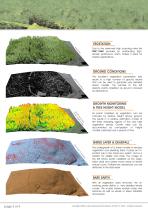
Due to the extremely high scanning rates the VUX®-1UAV provides an outstanding highdensity pointcloud, which makes it ideal for forestry applications. The excellent vegetation penetration rate results in a high number of ground returns that can be used to generate very detailed terrain models. The sample to the left depicts points classified as ground coloured by reflectance. GROWTH MONITORING & TREE HEIGHT MODEL g l rin e ito od on m m ht th eig ow h gr tree & All points classified as vegetation can be coloured by relative height above ground. This results in a relative estimation model of the...
Open the catalog to page 3
Precision Agriculture Applications ADVANTAGES OF LASER SCANNING IN VEGETATION MONITORING • ontinuous crop monitoring c during growth period • observation of irregularities in plant growth • detection of hail damage • analysis of terrain changes • yield estimation • observation of nutrient over- or undersupply • ongterm regular observation of growth l characteristics for geological evalution and classification By contrast to photogrammetry, which is limited to determining Digital Surface Models (DSM), the technique of laser scanning enables the user to capture data suitable for the generation...
Open the catalog to page 4All RIEGL LMS catalogs and technical brochures
 RiLOC-F / RiLOC-F-inside
1 Page
 RIEGL RiLOC-E-25
1 Page
 RiACQUIRE
4 Pages
 RIEGL VMX-2HA
8 Pages
 RIEGL VZ-4000i-25
8 Pages
 RIEGL VQ-860-G
6 Pages
 RIEGL VQ-840-GL
6 Pages
 RIEGL VZ-2000i
10 Pages
 RIEGL VQX-1 Wing Pod
4 Pages
 RIEGL VQ-580 II-S
8 Pages
 RIEGL VQ-1560 III-S
10 Pages
 RIEGL VQ-1260
10 Pages
 RIEGL VQ-1460
10 Pages
 RIEGL VPX-1
2 Pages
 RIEGL Monitoring Apps
4 Pages
 RIEGL VMY-1
4 Pages
 RIEGL VQ-680
8 Pages
 RIEGL VMY-2
8 Pages
 RIEGL V-Line CB23
2 Pages
 RIEGL VMQ -1HA
6 Pages
 RIEGL LD05e-A30-PH67
5 Pages
 RIEGL VZ-600i
8 Pages
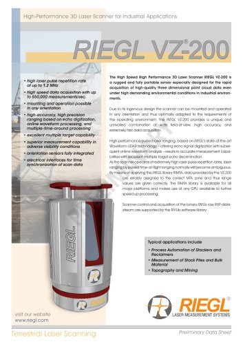 RIEGL VZ-200
6 Pages
 RIEGL VQ-840-G
6 Pages
 RIEGL VQ-840-GE
6 Pages
 RiMINING
4 Pages
 RIEGL VUX-180-24
6 Pages
 RIEGL VUX-240-24
6 Pages
 VUX-160²³
6 Pages
 RIEGL VUX-120²³
8 Pages
 RIEGL miniVUX-3UAV
6 Pages
 RIEGL V-Line UB23
2 Pages
 RIEGL BLS Overview
1 Page
 LIS TreeAnalyzer Plugin
2 Pages
 RIEGL VZ-400i
10 Pages
 RIEGL VMX-RAIL
6 Pages
 LIS GeoTec Plugin
2 Pages
 RIEGL VQ-480 II
6 Pages
 RIEGL VMR
4 Pages
 RDBLib
2 Pages
 RiSOLVE
4 Pages
 RIEGL VQ-1560 II-S
10 Pages
 RIEGL VQ-780 II-S
8 Pages
 RIEGL VQ-780 II
8 Pages
 RIEGL LD05-A10GF
10 Pages
 LD05e-A10, LD05e-A30
4 Pages
 RIEGL VUX-240
6 Pages
 RIEGL VQ-580 II
6 Pages
 RiPROCESS
4 Pages
 RIEGL VQX-2 Helicopter Pod
4 Pages
 RIEGL ULS Overview
1 Page
 RIEGL ALS Overview
1 Page
 RIEGL VMX-2HA-BC
2 Pages
 RIEGL PH-VUX
2 Pages
 RIEGL Topo-Bathymetry
4 Pages
 RIEGL miniVUX-SYS
4 Pages
 RIEGL VUX-1UAV-22
6 Pages
 RIEGL VUX-1HA-22
4 Pages
 RIEGL VUX-1LR-22
6 Pages
 RIEGL UAV Sensors & Systems
2 Pages
 RiSCAN PRO
4 Pages
 RIEGL VUX-SYS
4 Pages
 RIEGL VZ-400i
2 Pages
 RIEGL miniVUX-1UAV
4 Pages
 RiVLib
4 Pages
 RiUNITE
4 Pages
 RIEGL VQ-1560i-DW
10 Pages
 RIEGL VMZ
4 Pages
 RIEGL VZ-6000
6 Pages
 RiPANO
4 Pages
 RIEGL DR1560i
2 Pages
 RiHYDRO
2 Pages
 RIEGL LD05e-HT
4 Pages
 RIEGL LD05-HTGF
13 Pages
 RIEGL VZ-2000i
2 Pages


Archived catalogs
 RIEGL VZ-4000
6 Pages
 RIEGL miniVUX-1LR
4 Pages
 RIEGL miniVUX-2UAV
4 Pages
 RIEGL LD05-A80
5 Pages