- Catalogs
- RAE Systems
- PlumeRAE
PlumeRAE
1 /2Pages

PlumeRAE
1 /2Pages
Catalog excerpts

Releases of toxic materials present first responders with an immediate challenge- determining what actions need to be taken to protect nearby populations. They must answer a number of questions: • Where is the toxic plume headed, and • What areas need to be evacuated? • Who should shelter in place? • What roads should be closed? • How do we prioritize actions with limited resources available? Industry leaders RAE Systems, SAFER Systems and Coastal Environmental Systems have teamed to create PlumeRAE, a unique, turn-key solution that allows rapid monitoring and assess ment of situations involving the release PlumeRAE gives Municipal first respond ers information to make crucial decisions. • GPS-equipped AreaRAE wireless monitors placed in strategic locations measure the levels of critical toxic chemicals and communicate their measurements to a ProRAE Remote Base Station. • ProRAE Remote, running on a standard laptop computer, feeds this information to the Plume Measurement Software that is running on the same PC. • Weather data transmitted by a Coastal Environmental Systems WEATHERPAK completes the information package • The Plume Measurement Software, . developed by SAFER Systems, inte grates the information and shows users a picture of the toxic plume, the speed at which it is spreading, and the concentration of the toxic compound. PlumeRAE gives Municipal first respond ers the information they need along with decision support so that they can answer critical questions and take immediate, effective action. • Track and validate plume impact • Employ intelligent placement tactics for safely locating responders • Evaluate the toxicological effect on • Create emergency response strategy • Understand how long the event will • Save the event for post-event analysis
Open the catalog to page 1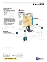
1 RAE Systems Rapid Deployment Kit - Four AreaRAE Wireless Detectors - ProRAE Remote Software preloaded - Complete package for charging - Carrying case for easy transportation ■ SAFER Systems powered Plume Measurement Software complete with GIS mapping data covering a single county (U.S. only; additional countries Non-U.S. customer pricing subject to local GIS data availablity. ■ Coastal Environmental Systems WEATHERPAK solid-state weather station monitoring wind speed, direc tion, temperature, solar radiation, 1 Municipal first responder 1 Large event emergency planning Plume Ma as ure mant...
Open the catalog to page 2All RAE Systems catalogs and technical brochures
 HAND & ARM PROTECTION
12 Pages
 Miller TechLine™ Kits
2 Pages
 Miller DuraHoistTM
8 Pages
 Miller ®
4 Pages
 FALL PROTECTION
22 Pages
 Miller H500 Series
8 Pages
 HONEYWELL RIG DOG™ GLOVES
12 Pages
 AreaRAE Pro
8 Pages
 RAELink3 Mesh
2 Pages
 RAEShare
1 Page
 RDK Rugged- Host
2 Pages
 SensorRAE 4R+
2 Pages
 Smoke Generation Tubes
1 Page
 SolarRAE
2 Pages
 ToxiRAE Pro CO2
2 Pages
 ToxiRAE Pro
2 Pages
 ToxiRAE Pro LEL
2 Pages
 ToxiRAE Pro PID
2 Pages
 UltraRAE 3000
2 Pages
 VOC Zeroing Tube
2 Pages
 WeatherPak
2 Pages
 Humidity Filtering II Tube
2 Pages
 MBeacon
2 Pages
 Wireless Alarm Bar
2 Pages
 MicroRAE
5 Pages
 MultiRAE Benzene
2 Pages
 MeshGuard
2 Pages
 AreaRAE Steel Z1
2 Pages
 AreaRAE Gamma Steel
2 Pages
 EchoView Host
2 Pages
 FMC-2 and FMC-4
2 Pages
 FMC-16
2 Pages
 FMC 2000
2 Pages
 EntryRAE
2 Pages
 miniDOSE
2 Pages
 DoseRAE Pro
2 Pages
 QRAE 3
2 Pages
 RAEGuard LEL
2 Pages
 RAEGuard PID
2 Pages
 RAE Systems
35 Pages
 BioHarness
2 Pages
 AutoRAE Lite for ToxiRAE 3
2 Pages
 AutoRAE Lite for QRAE II
2 Pages
 AreaRAE Steel Z2
2 Pages
 MiniRAE Lite Datasheet
2 Pages
 GammaRAE II R
2 Pages
 FMC-60
2 Pages
 FMC-40
2 Pages
 FMC-10
2 Pages
 ChemRAE
2 Pages
 AutoRAE 2
2 Pages
 AreaRAE Inert
2 Pages
 QRAE Plus
2 Pages
 QRAE II Pump
2 Pages
 QRAE II Diffusion
2 Pages
 ProRAE Guardian
2 Pages
 NeutronRAE II
2 Pages
 MultiRAE Pro
2 Pages
 MultiRAE Lite
2 Pages
 MultiRAE
2 Pages
 MiniRAE Lite
2 Pages
 MiniRAE 3000
2 Pages
 DoseRAE
2 Pages


Archived catalogs
 AreaRAE Gamma Steel
2 Pages
 EchoView Host
2 Pages
 ppbRAE 3000
2 Pages
 2010 RAE Systems Mini Catalogue
23 Pages
 HazRAE
2 Pages
 ToxiRAE 3 Datasheet
2 Pages
 Benzene - The Next Asbestos?
5 Pages


- Shoes
- Fabric clothing
- Mechanical protection protection gloves
- Anti-slip safety shoes
- Electrical protection safety shoes
- Work safety gloves
- Gas detector
- Industrial safety gloves
- Anti-static safety shoes
- 10 protection gloves
- 9 protection gloves
- 8 protection gloves
- EN 388 safety gloves
- Chemical protection safety gloves
- Handling protection gloves
- Work coveralls
- Industrial detector
- Plastic glove
- Thermal protection clothing
- 7 protection gloves