ATH1010
1 /19Pages

ATH1010
1 /19Pages
Catalog excerpts
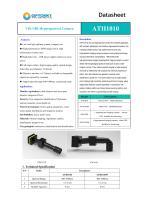
VIS-NIR Hyperspectral Camera Description: ATH1010 is low cost hyperspectral camera for industrial application, ◆ Low cost light splitting system, compact size with compact, lightweight, and miniature hyperspectral camera, and ◆ High performance CMOS image sensor, high it employs CMOS sensor, high performance-to-price ratio. performance-to-price ratio Hyperspectral imaging camera employs convex grating technology ◆ High frame rate,USB power supply requires no extra and good aberration characteristics. 1920X1200 pixels high-performance imaging Hyperspectral Imaging camera is used to ◆ Full target surface, high imaging quality optical design, dotted line spot diameter <0.5pixels ◆ Objective interface is C-Mount, available in changeable detect real time geological spectrum data such as plant, water creature, soil etc. They receive spectral imaging to make analysis, and build up relationship with physical and chemical properties of plants, then data collected are applied to research plant objectives required by customer classification, growth etc. The whole system has compact design, ◆ Support spectral range 400-1000nm, customized range and it employs high resolution, external push broom imaging, setup independent detection system separately in combination with outdoor rotation platform and indoor linear scanning platform, and Monitor Agriculture: plant diseases and insect pest, disaster, categories ID etc. Forestry: Tree categories identification, Phytomass, nutrient elements, forest health etc. Water Environment: Water quality parameters, water mounted in the UAVs to operate flight remote sensing. waste spatial distribution and migration analysis Soil Pollution: heavy metal waste L hyperspectral imaging camera ,narrow FOV,Suitable for fixed wing Minerals: Mineral mapping, ingredients explore, metallogenic prognosis etc. L hyperspectral imaging camera,wider FOV, Suitable for fixed wing City geological: substances classification and identification Spectral Range Spectral Resolution
Open the catalog to page 1
Detector Interface Detector Power Detector Target Surface Size Detector Raw Pixels Size Slit Width Pixels Binning Frame Rate Working Temp. Storage Temp.
Open the catalog to page 2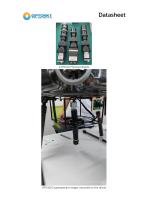
ATH1010 hyperspectral imager mounted on the drone
Open the catalog to page 4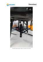
ATH1010 hyperspectral imager mounted on the drone
Open the catalog to page 5
Figure 1 Drone experiment Figure 2 Outdoor experiment sceneⅠ
Open the catalog to page 7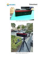
Figure 3 Outdoor experiment sceneⅡ Figure 4 Outdoor experiment scene
Open the catalog to page 8
Figure 5 Green plants measured spectrum 1.1. Geological Prospecting Application Spectral remote sensing technology evolved from the multi-spectral remote sensing technology represented by Landsat and took initial shape in the mid-1980s (Goets et al., 1985, Tong Qingxi et al., 2006). Due to its advantages of high spectral resolution and atlas integration, hyperspectral remote sensing technology has the ability of fine detection and analysis of surface rock mineral composition on a large scale. It can not only provide a macro image of the ground, but also determine the type and abundance of minerals...
Open the catalog to page 9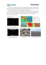
Datasheet The spectral wavelength ranges used for mineral mapping include visible light (400-700nm), NIR (700-1000nm), SWIR (1000-2500nm), and thermal IR (7000-15000nm). At present, the most widely used in mining is the short-wave infrared region (1000-2500nm). Because the frequency is close to the cofrequency and combined frequency of the chemical bond vibration in the mineral lattice, the mineral containing water or OH- (mainly layered silicate and clay) as well as some sulfate and carbonate minerals can be observed in the range of short-wave infrared wavelength.
Open the catalog to page 10
Figure 6 Application of hyperspectral imager in prospecting Soil salinization is one of the important ecological and environmental problems in arid and semi-arid areas. Soil salinization causes soil hardening, fertility decline, acid-base imbalance, land degradation and other consequences, which seriously restricts agricultural development in China and affects the strategic situation of sustainable development in China at present.Remote sensing technology, with its characteristics of large scale, wide range, strong timeliness and economy, makes up for the deficiency of traditional methods for...
Open the catalog to page 11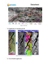
Figure 8 Field chart Figure 8 Hyperspectral image of plant growth 1.1 Forest Health Application
Open the catalog to page 12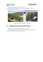
Datasheet Used for pest monitoring and forest resource assessment. Principle: The health of vegetation is related to greenness index, leaf area index, leaf moisture content and light use efficiency; Figure 9 Hyperspectral image of Pinus massoniana 1.2. Application of forest fire prevention Fire probability analysis, identification of fire range and ignition point. Vegetation ignition probability is related to greenness index, canopy water content, drought, and carbon attenuation caused by non-photosynthetic plants.
Open the catalog to page 13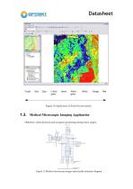
Figure 10 Application of forest fire prevention 1.3. Medical Microscopic Imaging Application Objective: online detection and navigation positioning during tumor surgery Figure 11 Medical microscope imager optical path schematic diagram
Open the catalog to page 14
Datasheet Is shown in the figure of medical microscopic imaging spectrometer principle diagram, the operating table for the target after the objective lens, microscope lens group is divided into three road, visual observation for the surgeon, all the way all the way for the assistant auxiliary visual observation, a routing imaging spectrometer detection, driven by a motor to imaging spectrometer measuring target space d scanning, imaging spectral information of the target under test, then through data analysis, image processing, through the display to the doctor. Figure 12 Medical microscope...
Open the catalog to page 15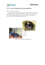
Datasheet 1.4. Airborne Imaging Spectroscopy Application Objective: Airborne remote sensing Application: Figure shows airborne imager consists of SpecVIEW-VIS, stable platform and POS modules. Figure 30 and Figure 31 show data was collecte. Figure 7 shows pseudo color image processed through geometric correction, flight strip spice and radiatation correction. Figure 31 shows typical geology spectral curve. Figure 14 Airborne remote sensing application
Open the catalog to page 16All Optosky(Xiamen)Photonics Inc. catalogs and technical brochures
 GF300
GF30012 Pages
 ATH6500
30 Pages
 ATH5500-17
21 Pages
 ATH1500-17
22 Pages
 ATH1500
23 Pages
 ATP9100/F
20 Pages
 ATR6600
10 Pages
 ATR6500
11 Pages
 ATR2500-1064
10 Pages
 ATR2500
4 Pages
 ATR6600Pro
10 Pages
 ATP8600
12 Pages
 ATLT6000
6 Pages
 Mid-IR Spectrometer ATP8250
2 Pages


- CMOS camera module
- Industrial camera module
- Concentration analyzer
- Liquids analyzer
- Infrared imager
- Monitoring camera system
- Detection camera system
- Gas detector
- Compact imager
- HD camera module
- Water analyzer
- Real-time analyzer
- Inspection imager
- Laboratory microscope
- Infrared analyser
- Temperature-controlled camera
- Industrial detector
- Monitoring detector