SHOALS-1000 Product Brochure

SHOALS-1000 Product Brochure
SHOALS-1000T is an advanced airborne laser bathymetry system designed for mapping shallow water and coastal regions. It integrates flight planning and data processing software, making it a comprehensive solution for coastal surveys, especially in challenging environments.
System Specifications
The SHOALS-1000T system includes an optical receiver, timing and data acquisition electronics, and utilizes green (532 nm) and near-IR (1064 nm) laser pulses. It is capable of collecting 1,000 water depth soundings per second and 10,000 coastal terrain elevation measurements per second, with coverage rates up to 70 km2 per hour.
Operational Procedures
Pre-flight operations involve mission planning using the SHOALS-1000 Ground Control System (GCS), which is user-friendly and facilitates seamless data processing. During airborne operations, the system compensates for aircraft movements using an inertial reference system and GPS data. Post-flight, data is processed using the GCS and third-party software for 3D visualization and editing.
Applications and Benefits
SHOALS-1000T data is applicable in shoreline mapping, nautical charting, navigation projects, and emergency response. The system is noted for its rapid coverage, flexibility, and mobility, making it ideal for areas where conventional systems are limited.
Safety and Compliance
The system is eyesafe for operators and surface observers when operated at standard altitudes.
Conclusion
Optech, with over 20 years of experience and a 90% market share, offers the SHOALS-1000T as a leading solution in airborne laser bathymetry, providing accurate and efficient coastal survey capabilities.
Catalog excerpts
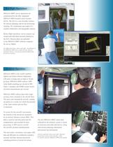
SHOALS-1000T survey operations are synchronized by the fully integrated SHOALS-1000 Ground Control System (GCS). The GCS is a user-friendly solution for mission planning, and for the processing, cleaning, 3D visualization and output of a seamless bathymetic and topographic dataset.Before flight operations, survey projects arecreated and individual missions planned in the GCS. Mission plans are uploaded to the SHOALS-1000T airborne computer for survey flights. > Pre-flight operations, above and right: Installation ofthe SHOALS-1000Tinto a small aircraft. Mission planning software, showing the...
Open the catalog to page 3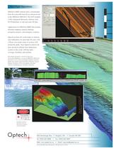
Eyesafe for operators and surface observers with system at standard operational altitude. > Copyright 2003, Optech Incorporated. All rights reserved. 110103 >
Open the catalog to page 4All Optech catalogs and technical brochures
 Galaxy PRIME Plus
4 Pages
 Galaxy PRIME
4 Pages
 Galaxy T2000
4 Pages
 CM2000
2 Pages
 CL-360
4 Pages
 T2000
T20004 Pages
 TLS-M3
2 Pages
 Lynx Camera
2 Pages
 Corridor Mapping
2 Pages
 PEGASUS HA500
2 Pages
 Lidar bathymetry
1 Page
 ORION M/C 300
1 Page
 Lynx Mobile Mapper
2 Pages
 ALTM Product Comparison
2 Pages
 Optech CZMIL
2 Pages
 GEMINI
2 Pages
 LYNX Brochure
16 Pages
 ORION H/M/C 300
2 Pages
 ILRIS Terrestrial Solutions
16 Pages
 ILRIS - LR
2 Pages
 Optech Hydrofusion
2 Pages
 Cavity Monitoring System
2 Pages
 AIRBORNE BROCHURE
16 Pages
 AQUARIUS
2 Pages


Archived catalogs
 Space Lidar Systems
2 Pages
 Rollei AIC Digital Camera
2 Pages
 DSS 322 Digital Camera
2 Pages
 ALTM Gemini
2 Pages
 CMS Wireless
2 Pages
 ILRIS Product Catalog
4 Pages
 ALTM NAV Software
1 Page
 SHOALS-3000 Product Brochure
2 Pages
 ALTM Gemini 167
2 Pages


- Liebherr real-time software
- Liebherr cloud software
- Liebherr quality software
- 3D scanning system
- Measurement scanner
- CAM software
- Portable scanner
- Software suite
- Office software
- Fixed holder
- Post-processing software
- LIDAR sensor
- Integrated scanner
- Surveying software
- Profile scanner
- Gimbal
- Management software suite
- Wireless scanner
- Automation software suite
- Monitoring software suite