

Optech Hydrofusion

Optech Hydrofusion
Optech HydroFusion is a comprehensive software suite designed for the Optech CZMIL system, aimed at enhancing data and product delivery by integrating lidar and imagery data sets. It automates the production of high-resolution 3D data and environmental image products using data from bathymetric lidar, hyperspectral imaging, and digital metric cameras.
The software was developed by Optech for the U.S. Government, specifically under the U.S. Army Corps of Engineers and the Joint Airborne Lidar Bathymetry Technical Center of Expertise, with testing support from the University of Southern Mississippi.
- Comprehensive processing for all three sensors from mission planning to data products.
- Includes lidar point cloud editing tools and a 3D volume visualizer for advanced analysis.
- Utilizes multi-sensor data fusion algorithms for benthic classification maps.
- Features a globe-based GUI for simplified data management across survey missions.
- Supports data sharing via an office server for multiple users.
The workflow includes flight planning, data collection, processing, analysis, and fusion, leading to various output products.
- Level 2: Auto processing of lidar point clouds.
- Level 4: Image generation including lidar depth grids, DEMs, and reflectance image mosaics.
- Level 5: Features and classification maps for benthic habitats and land cover.
- Level 6: Environmental products such as shoreline vectors and building footprints.
Catalog excerpts
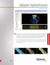
Optech HydroFusion Optech HydroFusion is a powerful end-to-end software suite for Optech CZMIL that accelerates data and product delivery, and improves the quality of information products derived from fused lidar and imagery data sets. It automatically produces high-resolution 3D data and environmental image products by combining data from three sensors—bathymetric lidar, hyperspectral imaging system and digital metric camera—within a data fusion paradigm. Optech HydroFusion software includes mission planning, data processing and final product generation, all in one system. Optech HydroFusion was designed by Optech for the U.S. Government under the auspices of the U.S. Army Corps of Engineers (USACE) and the Joint Airborne Lidar Bathymetry Technical Center of Expertise (JALBTCX). It was built and tested by Optech with the assistance of the University of Southern Mississippi (USM). Optech HydroFusion Information Sheet
Open the catalog to page 1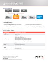
Optech HydroFusion Software Workflow Lidar Flight Planning Data Collection Data Processing Data Analysis Data Fusion Output Features & Benefits yy software package to handle processing for all 3 sensors— One from mission planning through to data products yy Built-in lidar point cloud editing tools yy Integrated 3D volume visualizer for advanced analysis and editing yy Multi-sensor data fusion algorithms to produce benthic classification maps yy Globe-based GUI to simplify locating, processing and managing data across survey missions yy Network and share data via an office server across multiple...
Open the catalog to page 2All Optech catalogs and technical brochures
 Galaxy PRIME Plus
4 Pages
 Galaxy PRIME
4 Pages
 Galaxy T2000
4 Pages
 CM2000
2 Pages
 CL-360
4 Pages
 T2000
T20004 Pages
 TLS-M3
2 Pages
 Lynx Camera
2 Pages
 Corridor Mapping
2 Pages
 PEGASUS HA500
2 Pages
 Lidar bathymetry
1 Page
 ORION M/C 300
1 Page
 Lynx Mobile Mapper
2 Pages
 ALTM Product Comparison
2 Pages
 Optech CZMIL
2 Pages
 GEMINI
2 Pages
 LYNX Brochure
16 Pages
 ORION H/M/C 300
2 Pages
 ILRIS Terrestrial Solutions
16 Pages
 ILRIS - LR
2 Pages
 Cavity Monitoring System
2 Pages
 AIRBORNE BROCHURE
16 Pages
 AQUARIUS
2 Pages


Archived catalogs
 Space Lidar Systems
2 Pages
 Rollei AIC Digital Camera
2 Pages
 DSS 322 Digital Camera
2 Pages
 ALTM Gemini
2 Pages
 CMS Wireless
2 Pages
 ILRIS Product Catalog
4 Pages
 SHOALS-1000 Product Brochure
4 Pages
 ALTM NAV Software
1 Page
 SHOALS-3000 Product Brochure
2 Pages
 ALTM Gemini 167
2 Pages


- Real-time software
- Cloud-based software
- Quality software
- 3D scanning system
- Measurement scanner
- CAM software
- Portable scanner
- Office software
- Fixed bracket
- Post-processing software
- LIDAR sensor
- Integrated scanner
- Surveying software
- Wireless scanner
- Profile scanner
- Gimbal
- Management software suite
- Automation software suite
- Monitoring software suite