Optech CZMIL
1 /2Pages

Optech CZMIL
1 /2Pages
Catalog excerpts
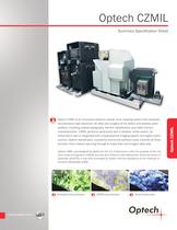
Optech CZMIL Optech CZMIL is an innovative airborne coastal zone mapping system that produces simultaneous high-resolution 3D data and imagery of the beach and shallow water seafloor, including coastal topography, benthic classification and water column characterization. CZMIL performs particularly well in shallow, turbid waters. Its bathymetric lidar is integrated with a hyperspectral imaging system and digital metric camera. Optech HydroFusion, a powerful end-to-end software suite, handles all three sensors—from mission planning through to fused lidar and imagery data sets. Optech CZMIL was designed by Optech for the U.S. Government under the auspices of the U.S. Army Corps of Engineers (USACE) and the Joint Airborne Lidar Bathymetry Technical Center of Expertise (JALBTCX). It was built and tested by Optech with the assistance of the University of Southern Mississippi (USM). Chlorophyll Concentration CDOM Concentration Sand Endmember Optech CZMIL Summary Specification Sheet
Open the catalog to page 1
Optech CZMIL Features & Benefits yy Accurate land and water-depth measurements with short laser pulse widths, enabling true shallow-water bathymetry yy Circular scan pattern providing two ‘looks’ at any target, for optimal object detection yy System integration and communication via TCP/IP; web-based interface for real-time in-field remote diagnostics yy Simultaneous high-density topo/bathy data from a single laser, using a segmented detector capable of up to 70,000 measurements/second yy Three sensors integrated on-board: lidar, hyperspectral, and RGB camera Applications yy Shoreline mapping...
Open the catalog to page 2All Optech catalogs and technical brochures
 Galaxy PRIME Plus
4 Pages
 Galaxy PRIME
4 Pages
 Galaxy T2000
4 Pages
 CM2000
2 Pages
 CL-360
4 Pages
 T2000
T20004 Pages
 TLS-M3
2 Pages
 Lynx Camera
2 Pages
 Corridor Mapping
2 Pages
 PEGASUS HA500
2 Pages
 Lidar bathymetry
1 Page
 ORION M/C 300
1 Page
 Lynx Mobile Mapper
2 Pages
 ALTM Product Comparison
2 Pages
 GEMINI
2 Pages
 LYNX Brochure
16 Pages
 ORION H/M/C 300
2 Pages
 ILRIS Terrestrial Solutions
16 Pages
 ILRIS - LR
2 Pages
 Optech Hydrofusion
2 Pages
 Cavity Monitoring System
2 Pages
 AIRBORNE BROCHURE
16 Pages
 AQUARIUS
2 Pages


Archived catalogs
 Space Lidar Systems
2 Pages
 Rollei AIC Digital Camera
2 Pages
 DSS 322 Digital Camera
2 Pages
 ALTM Gemini
2 Pages
 CMS Wireless
2 Pages
 ILRIS Product Catalog
4 Pages
 SHOALS-1000 Product Brochure
4 Pages
 ALTM NAV Software
1 Page
 SHOALS-3000 Product Brochure
2 Pages
 ALTM Gemini 167
2 Pages


- Liebherr real-time software
- Liebherr cloud software
- Liebherr quality software
- 3D scanning system
- Measurement scanner
- CAM software
- Portable scanner
- Office software
- Fixed holder
- Post-processing software
- LIDAR sensor
- Integrated scanner
- Surveying software
- Profile scanner
- Gimbal
- Management software suite
- Automation software suite
- Wireless scanner
- Monitoring software suite