LYNX Brochure
1 /16Pages

LYNX Brochure
1 /16Pages
Catalog excerpts
Lidar Imaging Solutions Complete Solutions for Mobile Surveying Lynx Mobile Mapper
Open the catalog to page 1
Optech Incorporated has been in the lidar business for over 35 years, helping customers around the world survey their world. We have created a family of advanced laser-based instruments that fit every survey need on Earth and beyond. And now Optech’s newest products incorporate our proprietary iFLEX™ technology. The result of decades of research into lidar measurement techniques and electronic design, iFLEX is the common platform at the core of Optech’s lidar technology—creating an infrastructure of unprecedented performance and accuracy across multiple products. Optech’s Lynx Mobile Mapper™...
Open the catalog to page 3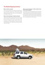
The Mobile Mapping Solution What is mobile surveying? Mobile surveying, loosely defined, is the collection of spatially-located data What are the advantages of high-resolution lidarbased mobile mapping? from a moving platform. Depending on the application, mobile mapping Lidar technology is made for mobile mapping because lidars can maintain high systems can include any number of sensors. In the survey industry mobile accuracy and high resolution from rapidly moving platforms. They operate at mapping systems typically consist of cameras, GPS, inertial navigation and, very rapid measurement rates...
Open the catalog to page 4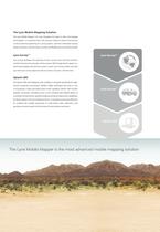
The Lynx Mobile Mapping Solution The Lynx Mobile Mapper not only integrates the latest in lidar and imaging technologies—it combines them with a proven software solution that focuses on the economical planning of a survey project, real-time information during project execution, and the rapid, accurate, and flexible post-processing of data. Lynx SurveyTM Lynx Survey™ Lynx Survey facilitates the planning of Lynx surveys and is also the real-time interface between the operator and the system. With Google Earth support, onthe-fly data display and real-time system control, Lynx Survey makes sure that...
Open the catalog to page 5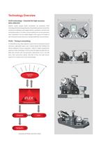
Technology Overview iFLEX technology – Essential for high-accuracy data collection Optech’s newest product family incorporates our proprietary iFLEX technology. We have leveraged decades of specialized expertise, honed in the commercial marketplace with rugged airborne, spaceborne, terrestrial and mining lidar products, to create a common platform for our next-generation lidars. Embedded in the Lynx Mobile Mapper, iFLEX captures the design of laser timing and receiver electronics, and high-speed data communications. iFLEX – Timing is everything To maximize accuracy, lidars depend on state-of-the-art...
Open the catalog to page 7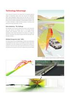
Technology Advantage Laser scanning has advanced to the stage where it can generate graphical images of extraordinary quality, dense with structural and topographic detail. Unlike photography, images derived from laser data are inherently three-dimensional, require no orthorectification and can be acquired at night because the laser operates independent of ambient lighting conditions. This is a distinct advantage in mobile terrestrial surveying, as scanning can be performed overnight while traffic is minimal. Data shadowing – The challenge One challenge in laser scanning is a phenomenon known...
Open the catalog to page 11
Applications Road The Lynx Mobile Mapper provides a remarkable capability for the rapid • Analysis of road infrastructure 3D mapping of highways, infrastructure and buildings using vehicle- • Location of encroaching overhead wires, light poles, and road signs mounted lasers. It is a proven solution for collecting engineering/survey- • Complete asset management grade lidar data over large areas where surveys are impractical with static lidar sensors but require an accuracy and resolution that exceed those of airborne technologies. Traveling at normal road speeds, day or night, the Lynx Mobile...
Open the catalog to page 12
About Optech Optech is the world leader in the development, manufacture and support of advanced lidar and imaging-based survey instruments. With operations and staff worldwide, Optech offers both standalone and fully integrated lidar and camera solutions in airborne terrestrial mapping, airborne laser bathymetry, mobile mapping, mine cavity monitoring, and industrial process control, as well as space-proven sensors. © Optech Incorporated. E&OE. Information subject to change without notice. Printed in Canada. 111031
Open the catalog to page 16All Optech catalogs and technical brochures
 Galaxy PRIME Plus
4 Pages
 Galaxy PRIME
4 Pages
 Galaxy T2000
4 Pages
 CM2000
2 Pages
 CL-360
4 Pages
 T2000
T20004 Pages
 TLS-M3
2 Pages
 Lynx Camera
2 Pages
 Corridor Mapping
2 Pages
 PEGASUS HA500
2 Pages
 Lidar bathymetry
1 Page
 ORION M/C 300
1 Page
 Lynx Mobile Mapper
2 Pages
 ALTM Product Comparison
2 Pages
 Optech CZMIL
2 Pages
 GEMINI
2 Pages
 ORION H/M/C 300
2 Pages
 ILRIS Terrestrial Solutions
16 Pages
 ILRIS - LR
2 Pages
 Optech Hydrofusion
2 Pages
 Cavity Monitoring System
2 Pages
 AIRBORNE BROCHURE
16 Pages
 AQUARIUS
2 Pages


Archived catalogs
 Space Lidar Systems
2 Pages
 Rollei AIC Digital Camera
2 Pages
 DSS 322 Digital Camera
2 Pages
 ALTM Gemini
2 Pages
 CMS Wireless
2 Pages
 ILRIS Product Catalog
4 Pages
 SHOALS-1000 Product Brochure
4 Pages
 ALTM NAV Software
1 Page
 SHOALS-3000 Product Brochure
2 Pages
 ALTM Gemini 167
2 Pages


- Liebherr real-time software
- Liebherr cloud software
- Liebherr quality software
- 3D scanning system
- Measurement scanner
- CAM software
- Portable scanner
- Software suite
- Office software
- Fixed holder
- Post-processing software
- Integrated scanner
- Surveying software
- Profile scanner
- Gimbal
- Management software suite
- Automation software suite
- Wireless scanner
- Monitoring software suite