ILRIS Terrestrial Solutions
1 /16Pages

ILRIS Terrestrial Solutions
1 /16Pages
Catalog excerpts

Lidar Imaging Solutions Complete Solutions for Terrestrial Surveying
Open the catalog to page 1
Optech's prominence as a world leader in the development and manufacture of advanced laser-based survey and imaging instruments extends over 35 years. During this time, Optech has worked closely with academic, government, military, naval, air force and spacebased organizations to meet their specialized application requirements. From this innovation heritage, our commercial terrestrial survey clients have come to depend on us to provide industry leadership in new technologies to maximize their data collection accuracy and efficiency. In 2001, Optech created the ILRIS-3D Intelligent Laser Ranging...
Open the catalog to page 3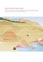
Complete Solutions for Today’s Surveyor Optech's ILRIS Laser Scanner enables surveyors to capture and define the world point by point. From single to multiple scans, you can coordinate and document your subject in 3 dimensions. An ideal complement to a surveyor's tool-kit, the ILRIS brings high-density engineering and survey-grade data to the table at amazingly high data collection rates.
Open the catalog to page 4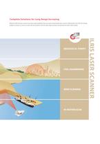
Complete Solutions for Long Range Surveying Optech’s ILRIS-LR Laser Scanner has more range capability than any other tripod-based laser scanner. Additionally, the ILRIS-LR’s design enables surveyors to scan ice, snow and wet surfaces with the same high accuracy and precision as other ILRIS models. CIVIL ENGINEERING MINE PLANNING IN-MOTION SCAN ILRIS LASER SCANNER GEOLOGICAL SURVEY
Open the catalog to page 5
ILRIS in Geology When scanning geological features, range, accuracy and precision are the key differentiators that set the ILRIS apart. This compact, portable laser scanner is field-ready. • Rock fall monitoring and analysis Its modular design enables you to plan an expedition, taking only the essential • Change detection components for each particular journey. • Outcrop data collection and modeling Yosemite National Park Glacier Point 37°43’38.66”N 119° 33’54.24”W
Open the catalog to page 6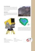
The ILRIS Advantage The ILRIS-HD and ILRIS-LR boast a laser repetition rate of 10 kHz while maintaining the superb ranging capability of the ILRIS-3D. With the Enhanced Range (ER) option, the ILRIS-HD’s range capability is increased while maintaining the scanner's industryleading range specification. High Definition The ILRIS family of scanners employs a dual-mirror scanning process that provides precise, gridded scan patterns in both X and Y axes. The even dispersion of points benefits modeling methodology and improves the final results. This graphic illustrates a TIN (Triangulated Irregular...
Open the catalog to page 7
ILRIS in Civil Engineering With the ILRIS Laser Scanner, high-definition scanning has never been easier and faster. Instrument orientation and position are measured or established with standard survey • Construction verification (as built) practices. These parameters can be entered into the scanner, enabling point cloud • Inspection tool alignment and registration in the field—no need to return to the office for post- • Engineering tool—volumes, surface processing. Accurate dimensions can now be extracted directly from the point cloud, calculations, spatial dimensioning permitting immediate construction...
Open the catalog to page 8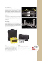
The ILRIS Advantage This highly accurate engineering tool can be applied in the inspection and monitoring of construction projects, and to capture details for the documentation of as-built or retrofit projects. Powerful 3D modeling tools are also available to model the subject efficiently, and to perform further data extraction by checking cross–sections, point-to-point distances and clearance measurements. Modularity The ILRIS is deployed by a single operator with all functionality available for easy operation. Set-up is rapid and simple, and the system is controlled via a wireless handheld...
Open the catalog to page 9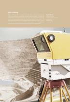
ILRIS in Mining Optech’s ILRIS Laser Scanner is a fully portable, laser-based, ranging and imaging system for the commercial survey, engineering, mining and industrial markets. A compact and • Volume calculations highly integrated instrument with digital image capture and sophisticated software tools, • Production/safety monitoring the ILRIS is an industry-leading solution that addresses the needs of commercial users. The • Slope analysis ILRIS is field-ready and requires no specialized training for deployment. Similar in size to a • Mine planning motorized total station, with on-board high-resolution...
Open the catalog to page 10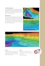
The ILRIS Advantage The ILRIS-HD and ILRIS-LR boast a true measurement rate of 10 kHz while maintaining the superb ranging capability of ILRIS-3D. With higher data collection rates and unmatched range and angular accuracies, the ILRIS delivers extremely precise point clouds for modeling and processing. Rapid Surveys Rapid Survey Mode offers georeferencing, resection and backsight functionality, dramatically reducing data collection and post-processing times. In this mode, the ILRIS controller automatically calculates the georeferenced positions of all scans from its location. It also provides...
Open the catalog to page 11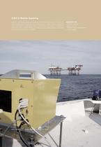
ILRIS in Mobile Scanning Optech's ILRIS Motion Compensation feature enables the collection of precise dynamic motion-compensated 3D data sets from a moving platform. When integrated with an INS system, ILRIS Motion Compensation delivers georeferenced data sets for a multitude of applications. Boats, off-road vehicles and airships are now suitable platforms to scan what you have never been able to scan before. Photo courtesy of Port of London Authority and NetSurvey Limited Applications • Shoreline mapping • Harbor entrances • Navigation features and obstacles • Coastal mapping
Open the catalog to page 12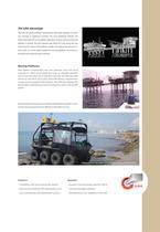
The ILRIS Advantage The ILRIS can perform Motion Compensation with either dual-axis or singleaxis scanning. In single-axis scanning—the more traditional method—the ILRIS is oriented at 90° to the platform’s direction of travel, and scans while the platform is moving. The ILRIS captures data along the Y-axis using only one mirror, but the motion of the platform enables it to capture data along the Xaxis as well. As a result, objects beside the scanning platform are scanned as the ILRIS moves past the areas of interest. Moving Platforms ILRIS Motion Compensation also uses dual-axis (step and stare)...
Open the catalog to page 13All Optech catalogs and technical brochures
 Galaxy PRIME Plus
4 Pages
 Galaxy PRIME
4 Pages
 Galaxy T2000
4 Pages
 CM2000
2 Pages
 CL-360
4 Pages
 T2000
T20004 Pages
 TLS-M3
2 Pages
 Lynx Camera
2 Pages
 Corridor Mapping
2 Pages
 PEGASUS HA500
2 Pages
 Lidar bathymetry
1 Page
 ORION M/C 300
1 Page
 Lynx Mobile Mapper
2 Pages
 ALTM Product Comparison
2 Pages
 Optech CZMIL
2 Pages
 GEMINI
2 Pages
 LYNX Brochure
16 Pages
 ORION H/M/C 300
2 Pages
 ILRIS - LR
2 Pages
 Optech Hydrofusion
2 Pages
 Cavity Monitoring System
2 Pages
 AIRBORNE BROCHURE
16 Pages
 AQUARIUS
2 Pages


Archived catalogs
 Space Lidar Systems
2 Pages
 Rollei AIC Digital Camera
2 Pages
 DSS 322 Digital Camera
2 Pages
 ALTM Gemini
2 Pages
 CMS Wireless
2 Pages
 ILRIS Product Catalog
4 Pages
 SHOALS-1000 Product Brochure
4 Pages
 ALTM NAV Software
1 Page
 SHOALS-3000 Product Brochure
2 Pages
 ALTM Gemini 167
2 Pages


- Liebherr real-time software
- Liebherr cloud software
- Liebherr quality software
- 3D scanning system
- Measurement scanner
- CAM software
- Portable scanner
- Software suite
- Office software
- Fixed holder
- Post-processing software
- LIDAR sensor
- Integrated scanner
- Surveying software
- Profile scanner
- Gimbal
- Management software suite
- Automation software suite
- Wireless scanner
- Monitoring software suite