

Galaxy PRIME Plus

Galaxy PRIME Plus
The document describes the ALTM Galaxy PRIME+, an advanced airborne lidar terrain mapper designed for maximum productivity in various survey applications, including wide-area, urban, and corridor mapping. It highlights the sensor's capabilities, technological enhancements, and specifications.
Key Features and Enhancements
- Continuous Operating Envelope: Utilizes PulseTRAK™ technology to eliminate data coverage gaps and ensure consistent point density, simplifying mission planning.
- Dynamic Field of View (FOV): SwathTRAK™ technology maintains fixed-width swaths for consistent point distribution, reducing the number of flight lines and operational costs.
- Boost Mode: Enhances range performance and detectability, improving small target detection and vegetation penetration.
- Real-time Sensor Protocol: Enables in-air target observation and collection monitoring, providing real-time data verification and immediate deliverables.
- High-Performance Scanner: Features a galvanometric scanner for superior scan speeds and improved data quality.
Productivity Examples
The document provides examples of productivity under different modes, highlighting point density, flight altitude, ground speed, swath width, and coverage rate.
Technical Specifications
- Sensor Performance: Operates at altitudes of 150-6000 m AGL with high accuracy in horizontal and elevation measurements.
- Laser Configuration: Features a 1064-nm near-infrared topographic laser with programmable pulse repetition frequency and beam divergence.
- Sensor Configuration: Includes a high-accuracy positioning system, dynamic FOV, and multipulse tracking algorithm.
- Data Storage and Power: Utilizes removable SSDs for data storage and requires 28 V, 400 W power.
- Optional Peripherals: Compatible with various cameras and stabilization systems, offering flexibility in sensor mounting.
Applications
The Galaxy PRIME+ is suitable for wide-area mapping, urban mapping, natural resource management, engineering and infrastructure modeling, and powerline and transportation corridor surveys.
Conclusion
The ALTM Galaxy PRIME+ offers advanced lidar technology with significant enhancements in performance, efficiency, and data quality, making it a leading choice for diverse mapping and surveying applications.
Catalog excerpts

Galaxy PRIME+ Airborne Lidar Terrain Mapper Maximum productivity for wide-area, mountain, urban and corridor survey applications Continuous Operating Envelope The new ALTM Galaxy PRIME+ is the ultimate wide-area lidar sensor, with best-of-class collection efficiency, smallest form factor and highest quality data sets to meet rigorous USGS lidar standards. Now with a 6000m AGL collection envelope and 1-MHz “on-ground” collection rate, Galaxy is quite simply the most productive sensor available with the lowest SWaP for maximum application and platform flexibility. Whether gyro-stabilized or fixed-mounted, high-altitude or low, one camera or six, full waveform or discrete, Galaxy PRIME+ excels in all application areas with unmatched configuration flexibility, while providing the highest data precision and accuracy available. » Wide-area mapping » Urban mapping APPLICATIONS » Engineering & infrastructure modeling » Natural resource management Increased Vertical Density » Powerline & transportation corridor Seamlessly Integrated Cameras
Open the catalog to page 1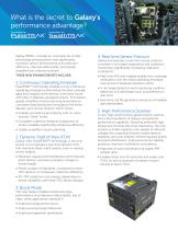
What is the secret to Galaxy’s performance advantage? Galaxy PRIME+ includes an innovative set of lidar technology enhancements that significantly increases sensor performance and collection efficiency, improves data quality, and greatly simplifies the collection process. 4. Real-time Sensor Protocol THESE NEW ENHANCEMENTS INCLUDE: » Real-time XYZi point display enables true-coverage 1. Continuous Operating Envelope PulseTRAK™ technology enables a truly continuous operating envelope by eliminating the data coverage gaps and irregular point density commonly found with other multipulse-equipped sensors....
Open the catalog to page 2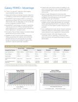
Galaxy PRIME+ Advantage » Unique real-time sensor protocol enables in-air point cloud display for true-coverage verification and immediate rapid-response deliverables in LAS format. » 1-MHz “on-ground” collection rate enables unprecedented point density. » Optech Flight Management Suite provides » Large performance envelope ensures collection integrated planning (with immersive 3D capabilities), navigation, and simultaneous control and monitoring for up to 8 sensors. confidence in both flat and rugged terrain types. » PulseTRAK™ technology enables a continuous operating envelope that can accommodate...
Open the catalog to page 3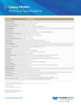
Galaxy PRIME+ Technical Specifications Parameter Sensor Performance Performance envelope 1, 2, 3, 4 Absolute horizontal accuracy 2, 3 Absolute elevation accuracy 2, 3 Laser Configuration Topographic laser Laser classification Pulse repetition frequency (effective) Beam divergence Laser range precision 5 Minimum target separation distance Range capture Up to 8 range measurements, including last Intensity capture Up to 8 intensity measurements, including last (12-bit) Sensor Configuration Position and orientation system POS AV™ AP60 (OEM); 220-channel dual frequency GNSS receiver; GNSS airborne antenna...
Open the catalog to page 4All Optech catalogs and technical brochures
 Galaxy PRIME
4 Pages
 Galaxy T2000
4 Pages
 CM2000
2 Pages
 CL-360
4 Pages
 T2000
T20004 Pages
 TLS-M3
2 Pages
 Lynx Camera
2 Pages
 Corridor Mapping
2 Pages
 PEGASUS HA500
2 Pages
 Lidar bathymetry
1 Page
 ORION M/C 300
1 Page
 Lynx Mobile Mapper
2 Pages
 ALTM Product Comparison
2 Pages
 Optech CZMIL
2 Pages
 GEMINI
2 Pages
 LYNX Brochure
16 Pages
 ORION H/M/C 300
2 Pages
 ILRIS Terrestrial Solutions
16 Pages
 ILRIS - LR
2 Pages
 Optech Hydrofusion
2 Pages
 Cavity Monitoring System
2 Pages
 AIRBORNE BROCHURE
16 Pages
 AQUARIUS
2 Pages


Archived catalogs
 Space Lidar Systems
2 Pages
 Rollei AIC Digital Camera
2 Pages
 DSS 322 Digital Camera
2 Pages
 ALTM Gemini
2 Pages
 CMS Wireless
2 Pages
 ILRIS Product Catalog
4 Pages
 SHOALS-1000 Product Brochure
4 Pages
 ALTM NAV Software
1 Page
 SHOALS-3000 Product Brochure
2 Pages
 ALTM Gemini 167
2 Pages


- Real-time software
- Cloud-based software
- Quality software
- 3D scanning system
- Measurement scanner
- CAM software
- Portable scanner
- Software suite
- Office software
- Fixed bracket
- Post-processing software
- Integrated scanner
- Surveying software
- Wireless scanner
- Profile scanner
- Gimbal
- Management software suite
- Automation software suite
- Monitoring software suite