

ALTM NAV Software

ALTM NAV Software
- Reduction in operating costs through optimized data collection and efficient flight operations.
- Effective and efficient mission planning with automatic creation of flight lines based on survey parameters.
- Real-time monitoring of swath coverage and graphical alerts for GPS-PDOP, POS, and Laser.
- Capability to import background maps and photos for visual reference and to delineate survey boundaries manually.
- Flexibility to adapt to changing requirements and fill data gaps before landing.
- Generation of comprehensive flight logs, including system changes, messages, alerts, and area coverage.
- Graphical mission planning toolkit.
- Real-time navigation display with a moving map.
- Unified graphical interface for ALTM controls.
- Coordinate converter supporting Lat/Long, WGS84, and UTM.
- Separate planners for wide areas and corridors with customizable displays.
Catalog excerpts
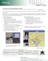
Optech offers a complete flight management system that reduces flight time and operating costs by monitoring swath coverage inf light and in real time.ALTM-NAV is a complete mission planning, project costing and qua lity control package that is an ideal complement to the Optech ALTM. Running on the ALTM system computer and included pilot display, the ALTM-NAV enables users to optimize data collection and realize cost savings with more efficient flight operations. ALTM-NAV allows you to: With ALTM-NAV you get: Reduce operating costs?Plan more effectively and efficiently?Monitor swath coverage in real-time?Create flight lines automatically from survey parameters?Develop survey plan and estimate flight times & costs?Import background maps and photos for visual reference tosurvey area?Import or manually delineate survey boundaries ?A simple, graphical mission planning toolkit?Real-time navigation display with moving map?Real-time swath coverage display?Unified graphical interface for ALTM controls ?Coordinate converter for Lat/Long, WGS84 and UTM ?Separate survey planners for wide areas and corridors ?Customizable displaysALTM-NAV is included with all new ALTM systems or it can bepurchased separately for existing ALTM systems > Monitor real-time graphical alerts: GPS-PDOP, POS, Laser?Trim flight line overlap without increasing risk > Fill Փdata gaps before landing?Generate flight logs, including in-flight system changes,messages, alerts and area coverage?Maintain flexibility as requirements change > Typical system, showing included pilot display with Course Deviation Indicator ALTM-NAV Main Screen Streamline workflow with the ALTM-NAV Flight Management System Real-time ALTMSystem Control&Status Monitor Proposal CostingCalculatorFlight PlannerQuality ControlAssess CoverageFlight Log&Project Report SPECIFICATIONS SUBJECT TO CHANGE WITHOUT NOTICEALTM-NAVSPECS/FEB2002 300 Interchange Way - Vaughan, ON - Canada L4k 5Z8 Tel: [905] 660-0808 - Fax: [905] 660-0829 - Web: www.optech.ca size="-2">
Open the catalog to page 1All Optech catalogs and technical brochures
 Galaxy PRIME Plus
4 Pages
 Galaxy PRIME
4 Pages
 Galaxy T2000
4 Pages
 CM2000
2 Pages
 CL-360
4 Pages
 T2000
T20004 Pages
 TLS-M3
2 Pages
 Lynx Camera
2 Pages
 Corridor Mapping
2 Pages
 PEGASUS HA500
2 Pages
 Lidar bathymetry
1 Page
 ORION M/C 300
1 Page
 Lynx Mobile Mapper
2 Pages
 ALTM Product Comparison
2 Pages
 Optech CZMIL
2 Pages
 GEMINI
2 Pages
 LYNX Brochure
16 Pages
 ORION H/M/C 300
2 Pages
 ILRIS Terrestrial Solutions
16 Pages
 ILRIS - LR
2 Pages
 Optech Hydrofusion
2 Pages
 Cavity Monitoring System
2 Pages
 AIRBORNE BROCHURE
16 Pages
 AQUARIUS
2 Pages


Archived catalogs
 Space Lidar Systems
2 Pages
 Rollei AIC Digital Camera
2 Pages
 DSS 322 Digital Camera
2 Pages
 ALTM Gemini
2 Pages
 CMS Wireless
2 Pages
 ILRIS Product Catalog
4 Pages
 SHOALS-1000 Product Brochure
4 Pages
 SHOALS-3000 Product Brochure
2 Pages
 ALTM Gemini 167
2 Pages


- Real-time software
- Cloud-based software
- Quality software
- 3D scanning system
- Measurement scanner
- CAM software
- Portable scanner
- Software suite
- Office software
- Fixed bracket
- Post-processing software
- LIDAR sensor
- Integrated scanner
- Surveying software
- Wireless scanner
- Profile scanner
- Gimbal
- Management software suite
- Automation software suite
- Monitoring software suite