AIRBORNE BROCHURE
1 /16Pages

AIRBORNE BROCHURE
1 /16Pages
Catalog excerpts

Complete Solutions for Airborne Surveying Lidar, Camera, and Multi-Sensor Solutions
Open the catalog to page 1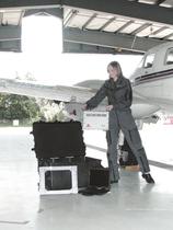
Optech Orion ultra-compact mapping system
Open the catalog to page 2
Optech’s prominence as a world leader in the development and manufacture of advanced lidar and camera survey instruments has endured for over 35 years. Optech works closely with commercial, government, military, and space-based organizations to meet their specialized application requirements. From this innovation heritage, our airborne clients have come to depend on us to provide industry leadership in new technologies and capabilities to maximize their collection accuracy and efficiency. A pioneer in lidar technology, Optech developed the world’s first commercial airborne laser terrain mapper,...
Open the catalog to page 3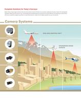
Complete Solutions for Today’s Surveyor Optech offers a broad range of airborne lidar and camera sensor solutions. Whether your business is application-focused or faced with small-payload constraints, Optech has the sensor for you. Incorporating many standard features to maximize your survey efficiency, our sensors go one step further with the key capabilities designed specifically to enable high-resolution models with the highest possible accuracy and precision. Camera Systems WIDE AREA MAPPING FMP™ CS-15000
Open the catalog to page 4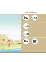
Lidar Systems CORRIDOR MAPPING HYDROGRAPHIC MAPPING
Open the catalog to page 5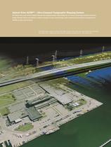
Optech Orion ALTM™ – Ultra-Compact Topographic Mapping System The Optech Orion is the world’s smallest complete lidar mapping solution. Representing the very latest in technology innovation and system design, the Orion delivers cost-effective, reliable surveying in an ultra-compact design, while maintaining all the features and performance benefits you have come to expect. The image below merges a Google Earth image (bottom) with a lidar point cloud model (top), illustrating the Optech Orion’s high-density data collection capability (survey flown at ~700 meters AGL).
Open the catalog to page 6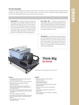
The Optech Orion ALTM incorporates the company’s proprietary iFLEX™ technology. The result of decades of research into lidar measurement techniques and electronic design, iFLEX™ is the common platform at the core of Optech’s next generation lidar technology—creating an infrastructure of unprecedented performance and accuracy across multiple products. Available in three models for increased application flexibility, the Optech Orion combines high-density data collection with high-precision results. is a high-altitude sensor that operates just as effectively at lower altitudes (150-4000 m AGL)....
Open the catalog to page 7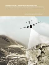
Optech Pegasus ALTM™ – High-Altitude, Wide Area Mapping System The Optech Pegasus is a breakthrough in conventional lidar system configuration. Using multiple lasers, the Pegasus operates at higher altitudes and with a higher ground point density than any other airborne lidar system on the market today. With a wide field of view and a convenient drop-in sensor design, the Optech Pegasus excels at maximizing collection efficiency without compromising data accuracy and precision. The image below merges a photograph (left) with a lidar digital surface model (DSM), illustrating the Optech Pegasus’...
Open the catalog to page 8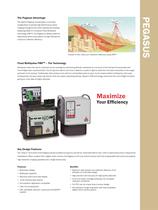
The Optech Pegasus incorporates a multi-laser configuration to provide high-performance active imaging throughout the entire operational envelope. Deploying Optech’s innovative Fixed Multipulse technology (FMP™), the Pegasus is ideally suited for high-density point-cloud capture at high altitudes for maximum collection efficiency. Double or even triple your collection efficiency using FMP™ Fixed Multipulse FMPTM – The Technology Multipulse clears the way for improved survey coverage by overcoming altitude constraints as a function of the timing limit associated with time-of-flight laser measurements....
Open the catalog to page 9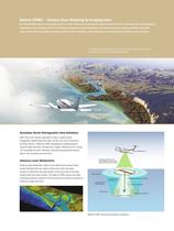
Optech CZMIL – Coastal Zone Mapping & Imaging Lidar The Optech CZMIL airborne bathymetric system is a fast, efficient and cost-effective remote sensing tool for on- and near-shore coastal mapping applications down to depths of 50 m. Combining a powerful water-penetrating lidar and advanced spectral imaging capabilities, this multisensor system delivers seamless bathymetry, water quality information, object detection, and bottom characterization in each aerial pass. The image below illustrates the coverage efficiency of Optech CZMIL’s on-shore and near-shore mapping capability. Seamless Aerial...
Open the catalog to page 10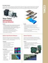
The Optech CZMIL hydrographic mapping sensor creates seamless data models with the latest in processing workflows and real-time data display capability. CZMIL is a multi-chassis design featuring system control and operation via a ruggedized laptop for increased flexibility and reliability. Optional L-Band (OmniSTAR™) provides real-time GPS correction for accurate surveying results when GPS ground stations are not available. Your Total Hydrographic Survey Solution Features • Products include detailed above- and below-water surface models with assigned confidence, supporting imagery, bottom reflectance...
Open the catalog to page 11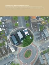
Complete Line of CS-Series Aerial Digital Cameras Optech has a full line of high-performance aerial digital cameras ready for standalone or lidar-integrated operation. Industry-award-winning designs are available with a wide array of multi-sensor mounts and lenses. Optech cameras are delivered with a universal controller that lets you build the sensor suite that will perfectly fit your application requirements.
Open the catalog to page 12
Optech’s full line of aerial digital cameras—a complete solution that delivers business value... every time. Solutions to Fit your Needs • Ruggedized sensor choices for acquiring visible, CIR, NIR and multispectral images • Flexible and expandable controller unit provides configuration options • Large and medium format cameras with True FMC for superior image quality • Field-replaceable shutters avoid recalibration and minimize down time • Interchangeable lenses guarantee your camera sensor investment • Kinematic mounts for easy mounting and precise positioning • Sensor capacities for specific...
Open the catalog to page 13All Optech catalogs and technical brochures
 Galaxy PRIME Plus
4 Pages
 Galaxy PRIME
4 Pages
 Galaxy T2000
4 Pages
 CM2000
2 Pages
 CL-360
4 Pages
 T2000
T20004 Pages
 TLS-M3
2 Pages
 Lynx Camera
2 Pages
 Corridor Mapping
2 Pages
 PEGASUS HA500
2 Pages
 Lidar bathymetry
1 Page
 ORION M/C 300
1 Page
 Lynx Mobile Mapper
2 Pages
 ALTM Product Comparison
2 Pages
 Optech CZMIL
2 Pages
 GEMINI
2 Pages
 LYNX Brochure
16 Pages
 ORION H/M/C 300
2 Pages
 ILRIS Terrestrial Solutions
16 Pages
 ILRIS - LR
2 Pages
 Optech Hydrofusion
2 Pages
 Cavity Monitoring System
2 Pages
 AQUARIUS
2 Pages


Archived catalogs
 Space Lidar Systems
2 Pages
 Rollei AIC Digital Camera
2 Pages
 DSS 322 Digital Camera
2 Pages
 ALTM Gemini
2 Pages
 CMS Wireless
2 Pages
 ILRIS Product Catalog
4 Pages
 SHOALS-1000 Product Brochure
4 Pages
 ALTM NAV Software
1 Page
 SHOALS-3000 Product Brochure
2 Pages
 ALTM Gemini 167
2 Pages


- Liebherr real-time software
- Liebherr cloud software
- Liebherr quality software
- 3D scanning system
- Measurement scanner
- CAM software
- Portable scanner
- Software suite
- Office software
- Fixed holder
- Post-processing software
- LIDAR sensor
- Integrated scanner
- Surveying software
- Profile scanner
- Gimbal
- Management software suite
- Automation software suite
- Wireless scanner
- Monitoring software suite