Mapper 3D - User Manual
1 /43Pages

Mapper 3D - User Manual
1 /43Pages
Catalog excerpts

NOVATEST - SUBvysor / Mapper 3D Mapper 3D ver 3.9.1.24 User Manual I NOVATEST Engineering Solutions Contact us for: purchase, rental, quote. Via Albertini, 36/F8 c/o Gross Ancona 60131 Ancona (AN)
Open the catalog to page 1
NOVATEST - SUBvysor / Mapper 3D Novatest Via Albertini, 36/F8 c/o Gross Ancona 60131 Ancona (AN) - T. +39 071.2415386 [email protected] - novatest.it All pictures in this User Manual are given for reference purpose only, and may differ from actual product appearance. Product design and specification may be changed by manufacturer without notification.
Open the catalog to page 2
NOVATEST - SUBvysor / Mapper 3D 3 Idea of Mapper 3D program 5 SUBvysor program package 5 Area of Displayed GPR profiles 15 Before sounding process 19 Base Line and profiles arrangement 19 Adding plan/map of the location to project 20 Adding a new profile 24 Adding the saved profile to the project 25 Deleting profile from the site 25 Assigning another profile as etalon 25 Modifying the profile in GPR Logger 26 Batch processing of GPR profiles 26 Modifying the profile position 26 Markers of underground objects 27 Adding underground object marker 27 Adding surface markers 27 Modifying markers parameters...
Open the catalog to page 3
NOVATEST - SUBvysor / Mapper 3D
Open the catalog to page 4
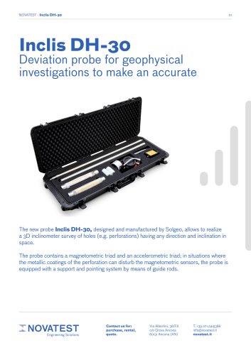
NOVATEST - SUBvysor / Mapper 3D General Information Idea of Mapper 3D program Mapper 3D program is designed to map GPR data and detected underground objects on a plan or a map. This program helps users to manage sounding process with SUBvysor GPR on some a territory. SUBvysor program package Mapper 3D program is included in SUBvysor software package as a mapping tool. Another program of this package (GPR Logger) is served for managing of a sounding process and for GPR data processing. Computer Requirements The system requirements for the GPR Logger software are: • Computer (laptop) operated by...
Open the catalog to page 5
NOVATEST - SUBvysor / Mapper 3D This User Manual uses the following terms and definitions. GPR profile (or profile) - is a two-dimensional image in the coordinates of depth (vertical) and traveled distance (horizontal). Profile consists of a set of traces. Amplitude of the traces of the profile is displayed by color. The amplitude-color dependence is determined by color palette. For example, in the case of palette by default (gray- scale), minimum value corresponds to black, maximum to white, and zero level to gray color. The profiles are represented by vectors (a line with an arrow) on a map....
Open the catalog to page 6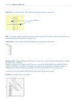
NOVATEST - SUBvysor / Mapper 3D 7 Base line - is a line on a plan. The profiles (vectors) are placed in relation to it. NOVATEST - SUBvysor / Mapper 3D 7 Site - a complex of data, including: base line, profiles (vectors) and markers. One site may content unlimited quantity of profiles and only one base line. Object tree - a tree-structured list of all objects of a project: sites and markers. Etalon profile - a selected (etalon) GPR profile of each site. In Object tree the etalon profile is marked by check mark ■* S/ . Mapper 3D program can display profiles that were acquired by different GPR...
Open the catalog to page 7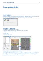
NOVATEST - SUBvysor / Mapper 3D Program description MAIN MENU Mapper 3D program has Multiple document interface (MDI), that allows user to open many projects at the same time. The Main menu contains Menu and the field with tools and buttons. PROJECT WINDOW Each project is displayed in its own window. The Project window is split to 3 parts (see in picture from left to right): • Objects Tree with objects properties; • Project Plan; • Displayed GPR profiles. Each part has its own tools panel with control buttons. By moving (left-right) the separator between the Project Plan part and Displayed GPR...
Open the catalog to page 8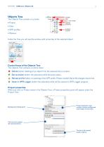
NOVATEST - SUBvysor / Mapper 3D Objects Tree The Objects Tree consists of 4 levels: • Project • Sites • GPR profiles • Markers Under the Tree you will see the window with properties of the selected object. Control items of the Objects Tree The Objects Tree contains 4 control items: Delete button: deleting of an object from the selected site or project. Set as etalon button: the selected profile becomes etalon. Reload profile button: re-openning of the GPR profile. Please consider that all the changes may be lost. Open in GPR Logger button: the selected profile will be opened in GPR Logger program....
Open the catalog to page 9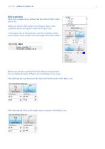
NOVATEST - SUBvysor / Mapper 3D 10 NOVATEST - SUBvysor / Mapper 3D 10 Site properties Each new created site by default has the name of Sitel, Site2 and so on. When you click on Site name in the Objects Tree, a Site properties panel will appear under the Project Tree. In the upper part of the panel you can find a statistics about total number of the profiles and total length of all site profiles: Title of Site Sitel Number of profiles: 11 Total length of profiles: 49, lm Below you will see a panel of the site's Base Line properties. You can define the style of Base Line coordinates in two ways:...
Open the catalog to page 10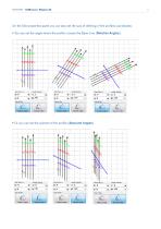
NOVATEST - SUBvysor / Mapper 3D On the Site properties panel you can also set the way of defining of the profiles coordinates: • You can set the angle where the profile crosses the Base Line (Relative Angles), • Or you can set the azimuth of the profile (Absolute Angles).
Open the catalog to page 11
NOVATEST - SUBvysor / Mapper 3D You can change Wave speed in the Site properties. You can select the color for the by clicking on Color button Base Line. » When you add profiles to the site, this parameter will be defined by the wave speed of the etalon profile. Therefore, the wave speed of the site and of all profiles will be equal to the wave speed of etalon profile. If you change the wave speed of the site, the wave speeds of all the site's profiles will be changed equally. » All numerical parameters in the program you can enter in two ways: by inputting numbers from a keyboard or with arrows...
Open the catalog to page 12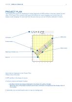
NOVATEST - SUBvysor / Mapper 3D PROJECT PLAN The Project Plan serves for displaying of mutual alignment of GPR profiles on the plan relative to each other. The Project Plan contains tools panel with buttons for scale changing, and control items for display mode changing. On each side from the plan area you can see the axes calibrated in meters. Tools panel Surface marker Object marker Beginning of the Base Line Base line Items that are displayed on the Project Plan: • Base Lines of the sites • GPR profiles in the shape of vectors • Surface markers and object markers » Surface markers are always...
Open the catalog to page 13All Novatest catalogs and technical brochures
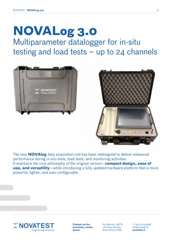 NOVALog 3.0 - Tehnical Sheet
4 Pages
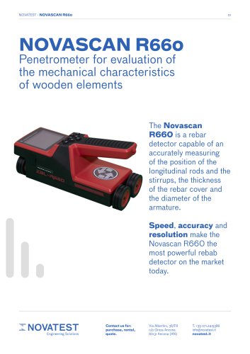
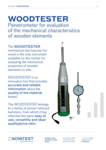 Woodtester - Technical Sheet
2 Pages
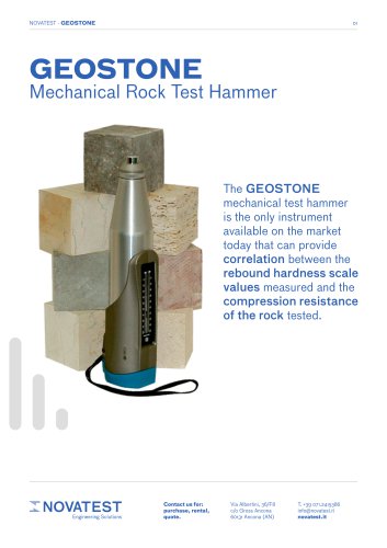 Geostone - Technical Sheet
3 Pages
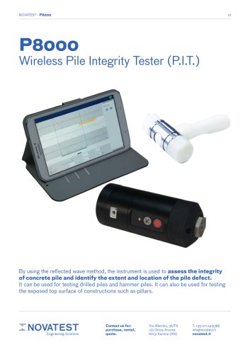 P8000 - Technical Sheet
2 Pages
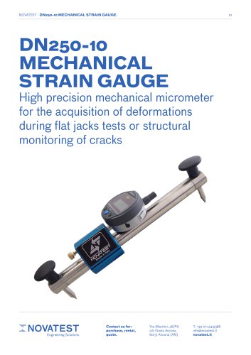
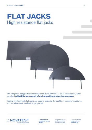 Flat Jacks - Technical Sheet
2 Pages
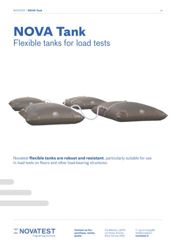 NOVATank
3 Pages
 U.S.A. E74 - Technical Sheet
2 Pages
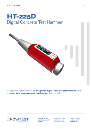 HT-225D - Technical Sheet
2 Pages
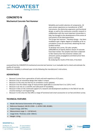
 CONCRETO N - Technical Sheet
3 Pages
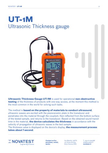 UT-1M - Technical Sheet
7 Pages
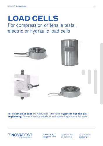 Load Cells - Technical Sheet
2 Pages
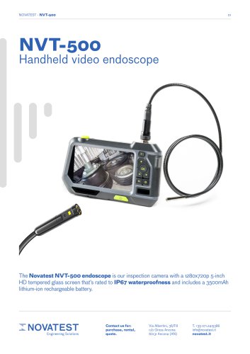 NVT-500 - Technical Sheet
2 Pages
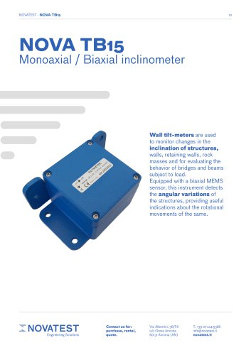 NOVA TB15 - Technical Sheet
3 Pages
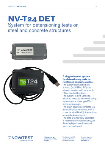 NV-T24 DET - Technical Sheet
3 Pages
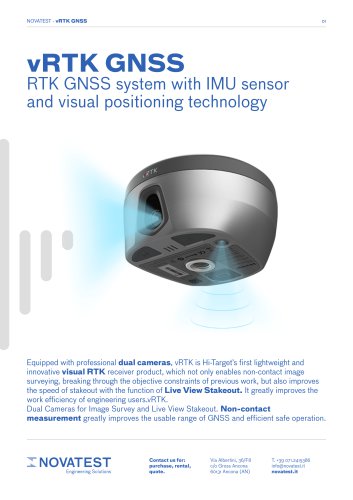 vRTK GNSS - Technical Sheet
6 Pages
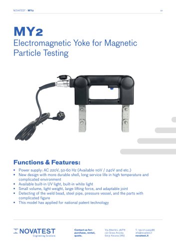 MY2 - Technical Sheet
2 Pages
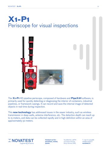 X1-P1 - Technical Sheet
4 Pages
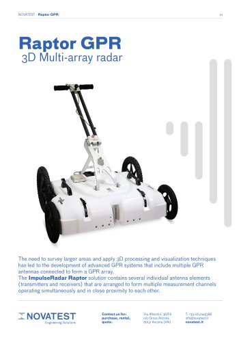 GPR Raptor - Technical Sheet
7 Pages
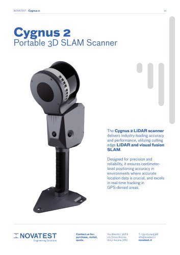 CYGNUS 2 - Technical Sheet
4 Pages
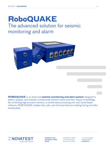 RoboQUAKE - Technical Sheet
3 Pages
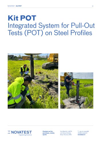 Kit POT - Technical Sheet
5 Pages
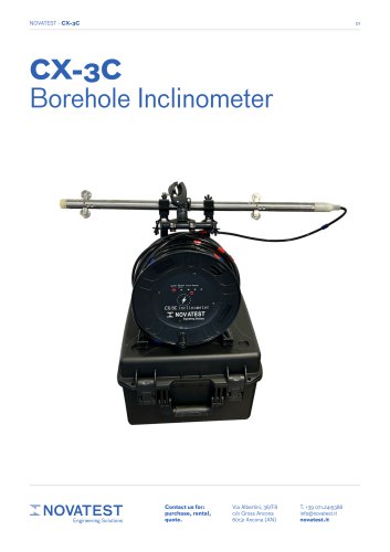 CX-3C - Technical Sheet
4 Pages
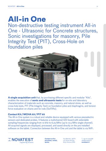 ALL-IN-ONE - Technical Sheet
6 Pages
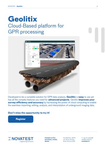 GEOLITIX - Technical Sheet
7 Pages
 uBlox - Technical Sheet
3 Pages
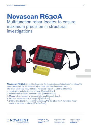 Novascan R630A - Technical Sheet
11 Pages
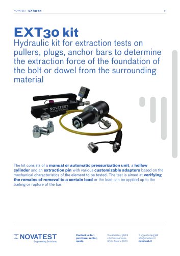 EXT30 kit - Technical Sheet
2 Pages
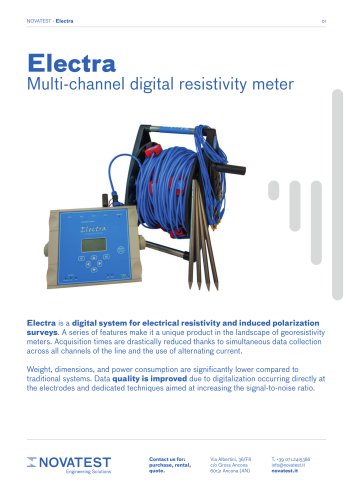 Electra - Technical Sheet
5 Pages
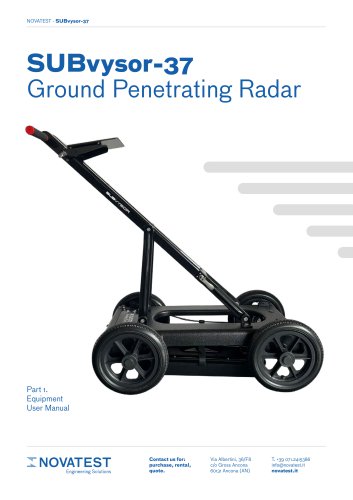 SUBvysor-37 GPR User Manual
29 Pages
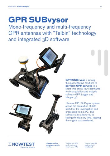 GPR SUBvysor - Technical Sheet
12 Pages
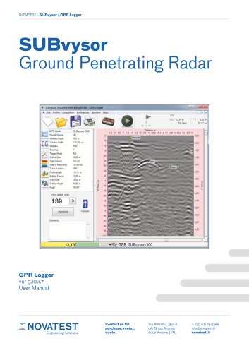 GPR Logger - User Manual
94 Pages
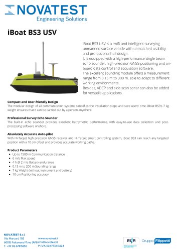 iBoat BS3 USV
1 Page
 Qmini A10
2 Pages
 HT-32-Automatic Level
1 Page
 Qbox-20
2 Pages
 А2072 IntroScan
2 Pages
 iRTK5 GNSS RTK SYSTEM
2 Pages


Archived catalogs
 Products Overview NDT
16 Pages
 MICRODRONES
181 Pages
 IHand30
2 Pages
 iBoat BS3 USV
2 Pages
 SLAM100
2 Pages
- Test machine
- Vessel
- Digital imager
- Nora load cell
- Industrial camera module
- Data logger
- Nora analysis software
- Measuring machine
- Infrared imager
- Nora tension/compression load cell
- Monitoring camera system
- Nora steel load cell
- Cloud-based software
- Calibration system
- Indentation hardness tester
- Level probe
- Liquid level sensor
- USB camera module
- Detection camera system
- Nora stainless steel load cell