- Catalogs
- Northrop Grumman SYNOPTICS
- National Polar-Orbiting Operational Environmental Satellite System (NPOESS)
National Polar-Orbiting Operational Environmental Satellite System (NPOESS)
1 /20Pages

National Polar-Orbiting Operational Environmental Satellite System (NPOESS)
1 /20Pages
Catalog excerpts

National Polar-orbiting Operational Environmental Satellite System on the front lines of global weather and climate
Open the catalog to page 1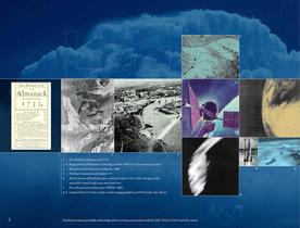
1. Poor Richard’s Almanac, circa 1733 2, 4. Images from Earth Resources Technology Satellite (ERTS-1), later renamed Landsat 3. Kite photo of San Francisco Earthquake, 1906 5. Northrop Grumman-built Explorer VI 6. The first picture of Earth from space, taken by Explorer VI in 1959, showing a sunlit area of the Central Pacific ocean and cloud cover 7. First television picture from space (TIROS, 1960) 8, 9. Captured Nazi V2 rocket used for weather imaging platform at White Sands, New Mexico 2 Northrop Grumman gratefully acknowledges photos and data generously provided by DoD, NOAA, NASA and other...
Open the catalog to page 2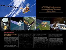
A Proud Legacy DoD/NOAA/NASA Systems Pave Way for NPOESS For centuries, weather observing tools consisted of the human eye and senses. When Poor Richard’s Almanac was first published by Benjamin Franklin in the 1700s, the basic observing tools were instruments that measured the rainfall, barometric pressure, temperature, humidity, and wind speed. Communications advances in the 19th century, starting with the telegraph, made it possible for meteorologists to make observations at different locations, develop real-time maps of weather and make weather predictions. As humankind extended its reach...
Open the catalog to page 3
Civilian Benefits Protecting Lives and Property Our daily lives and economic well-being depend on accurate, timely weather forecasts – minutes, hours, days, weeks, and even months in advance. Seasonal and long-term climate change over decades introduces uncertainty that menaces our way of life, affecting our food and water supply, transportation and energy systems, the safety of our coastlines, and the spread of disease. NPOESS will help mitigate that uncertainty and provide clarity, helping us better understand where and how changes will occur. The system will provide weather and climate information...
Open the catalog to page 4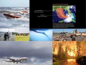
5 Current Cone of Uncertainty Future NPOESS Cone of Uncertainty NPOESS’ improved environmental observations will lead to more accurate hurricane and tropical storm track predictions. Microwave sensors on NPOESS spacecraft will “see” through clouds and scrutinize conditions, pinpointing areas of severest weather, intense precipitation and providing safety zones for hurricane aircraft. Improved Hurricane Forecasts
Open the catalog to page 5
Weather affects tactical operations. Hotter, drier, or wetter conditions affect tanks, aircraft and carrier ships, potentially increasing the cost of operation, maintenance and repair while shortening the life cycle of these resources. Military and intelligence analysts predict climate change will force sweeping changes in the location of bases, training methods and planning for future missions. Our forces’ mission is expanding to accommodate geopolitical crises that call for frequent disaster relief, containment of conflicts, and humanitarian relief caused by drought, economic collapse, mass...
Open the catalog to page 6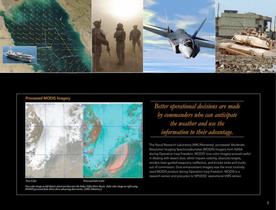
7 Better operational decisions are made by commanders who can anticipate the weather and use the information to their advantage. Processed MODIS Imagery True Color Processed False Color True color image on left depicts cloud and dust over the Indus Valley River Basin. False color image on right using MODIS processed data shows three advancing dust storms. (NRL/Monterey) The Naval Research Laboratory (NRL/Monterey) processed Moderate Resolution Imaging Spectroradiometer (MODIS) imagery from NASA during Operation Iraqi Freedom. MODIS’ true color imagery proved useful in dealing with desert dust,...
Open the catalog to page 7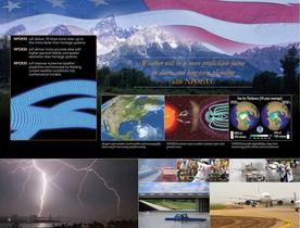
1 Weather will be a more predictable factor in short- and long-term planning with NPOESS. 8 NPOESS will deliver 10 times more data, up to five times faster than heritage systems. NPOESS will deliver more accurate data with higher spectral fidelity and spatial resolution than heritage systems. NPOESS will improve numerical weather prediction and forecasts by feeding current weather conditions into mathematical models. Imagers and sounders track weather and oceanography data used for nowcasting and forecasting. NPOESS monitors space weather to ptotect space and ground assets. NPOESS provides high...
Open the catalog to page 8
A National Asset Next-Generation Weather and Climate Monitoring NPOESS is the first of its kind – a comprehensive system comprised of satellites, sensors, data processing and ground system elements that will provide faster access to improved operational weather and climate information. It will send more data, faster, with greater accuracy, spatial and spectral fidelity than existing systems. The system merges separate military and civilian satellite programs into a single solution, and combines and improves attributes of the DMSP, POES, and elements of the EOS satellites. The NPOESS’ top system...
Open the catalog to page 9
Typical Environmental Sensors & Data Imagers provide relatively high spatial resolution imagery and measurements at visible and infrared wavelengths Cloud cover, sea ice, ground surface imagery Sounders provide profiles of environmental parameters by measuring infrared and microwave radiation Vertical temperature and moisture profiles Radiometers measure radiant energy flux from various environmental sources depending on where the sensors are pointed Solar and Earth energy balance In-situ monitors measure charged particles, electromagnetic fields, and solar radiation at the spacecraft Space environment...
Open the catalog to page 10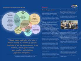
Science Climate Change on Record From hundreds of miles up in space, Earth observing satellites have been making significant contributions to monitoring weather and climate change for some 50 years. Satellites gave us the first measurement of Earth’s greenhouse effect, measuring both the amount of sunlight that hit the top of Earth’s atmosphere and the amount of heat that Earth sent back into space. NPOESS will extend measurements collected by research satellites, including the Northrop Grumman-built Aqua and Aura, providing scientists with a continuous data record needed to understand climate...
Open the catalog to page 11All Northrop Grumman SYNOPTICS catalogs and technical brochures
 Air Spaced Polarizer
2 Pages
 Ruby ? Cr3+: Al2O3
2 Pages
 Alexandrite
2 Pages
 Contract Crystal Growth
1 Page
 Chandra X-Ray Observatory
2 Pages
 Advanced EHF Payloads (AEHF)
2 Pages
 Fire Scout Navy Brochure
6 Pages
 MQ-8B Fire Scout
6 Pages
 B-2 Spirit Bomber
2 Pages
 X-47B UCAS
2 Pages
 E-8C
E-8C2 Pages
 E-2D Advanced Hawkeye
6 Pages
 E-2C Hawkeye 2000
6 Pages


