


- Company
- Products
- Catalogs
- News & Trends
- Exhibitions
Aerial Applications

Aerial Applications
Overview
This document outlines various aerial application services focused on inventory management, surveying, inspection, and mapping. It highlights specific use cases such as automated semi-trailer counting, thermal area measurement, and railtrack component detection.
Main Sections and Key Points
Inventory Management and Counting
- Automated counting of semi-trailers to improve inventory accuracy and efficiency.
- General counting services likely supported by aerial imagery.
Aerial Survey and Mapping
- Use of aerial surveys for mapping purposes, including measurement of deforestation areas.
- Thermal area measurement techniques applied to assess environmental or structural conditions.
Inspection Services
- Railroad inspection focusing on railtrack component detection and analysis to ensure infrastructure integrity.
- Building inspections possibly leveraging aerial imagery for structural assessments.
Data Visualization and Color Coding
- Color-coded data representation with percentages: Yellow (27.26%), Dark Blue (22.78%), Orange (25.88%), Light Blue (11.27%).
- These colors likely correspond to different categories or types of data collected during aerial applications.
Contact Information
For further inquiries or service requests, contact:
Phone: 614-407-4510
Website: mipar.us
Email: [email protected]
Summary
The document serves as a concise overview of aerial application capabilities primarily aimed at inventory management, environmental measurement, and infrastructure inspection. It emphasizes automated and thermal measurement technologies and provides contact details for service engagement.
Catalog excerpts

Aerial Applications Inspection Building Dark Blue Light Blue Thermal area measurement Inventory Management Count Automated semi-trailer counting Aerial Survey Railroad Railtrack component detection and analysis 614-407-4510
Open the catalog to page 1
Aerial Applications Inspection Building Dark Blue Light Blue Thermal area measurement Inventory Management Count Automated semi-trailer counting Aerial Survey Mapping
Open the catalog to page 2All MIPAR catalogs and technical brochures
 Porosity Analysis
2 Pages
 Cracks and Pores
2 Pages
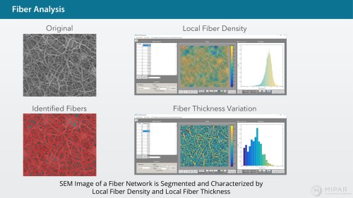 Fibers Analysis
1 Page
 Fiber Cross Sections
2 Pages
 Coarse Fibers
2 Pages
 Satellite Particles
2 Pages
 Powder Particles
2 Pages
 Crystals
2 Pages
 Cracks in Particles
2 Pages
 Ti Alloy Microstructure
1 Page
 Gamma Prime Detection
1 Page
 Alpha Beta in Ti
1 Page
 Twin Grains Analysis
1 Page
 Grains Analysis
1 Page
 Largest Grain
1 Page
 Ceramics Grains 2
2 Pages
 Ceramic Grains
1 Page
 Beta Grains in Ti
1 Page
 MIPAR API
2 Pages
 Additive Manufacturing
1 Page
 Metals infographic
1 Page
 Ceramics infographic
1 Page
 Battery Flyer
1 Page
 Banner 2
1 Page
 Banner 1
1 Page
 AMP 2019 Article
7 Pages
 MIPAR LIVE BROCHURE
4 Pages
 MIPAR - QAQC Brochure
12 Pages
 MIPAR Brochure
6 Pages


Archived catalogs
 Nanoparticles
2 Pages
 Deep Learning
1 Page
- Automation software solution
- Management software solution
- Analysis software solution
- Process software
- Real-time software
- Windows software
- Industrial software
- 3D software solution
- Measurement software
- Interface software
- Visualization software solution
- Quality software
- Automated software
- Development software
- Network software
- Reporting software
- Engineering software
- Machine software
- Optimization software
- Test software