
- Catalogs
- Microdrones
- Microdrones Company and Product Overview


Microdrones Company and Product Overview

Microdrones Company and Product Overview
Microdrones specializes in integrating UAVs with advanced sensors and geospatial hardware to enhance safety, efficiency, and profitability across various industries through innovative UAV solutions.
- Surveying and Mapping: Provides complete UAV solutions for accurate and efficient aerial surveying.
- Inspection Tools: Facilitates safer inspections of infrastructure like power lines and pipelines.
- Construction and Land Development: Offers tools for creating accurate maps and monitoring project progress.
- Agriculture: Empowers farmers with data for crop health monitoring and yield improvement.
- Mining: Offers cost-effective mapping and surveying solutions.
- Research: Partners with researchers to advance knowledge and solve global challenges.
Microdrones provides robust UAV platforms like the md4-3000, integrated with precise sensors for LiDAR data collection, supporting end-to-end workflows with software like mdCockpit and mdInfinity.
- High-quality data collection with precise georeferencing.
- Versatile applications across various sectors.
- Advanced LiDAR systems for dense data collection.
The document details various drone-based LiDAR and mapping systems, including mdLiDAR3000 aaS and mdMapper3000DµoG VHR aaS, designed for applications like surveying, construction, and mining.
Each system is equipped with specific components, such as the Riegl miniVUX-2UAV LiDAR sensor and high-resolution cameras, with detailed technical specifications like take-off weight and operational temperature range.
The mdInfinity software ecosystem offers modules for trajectory processing, georeferencing, and point cloud direct colorization.
The systems are versatile, supporting applications like area mapping and inspection, with advantages such as resilience to harsh weather and efficient flight planning.
Microdrones offers comprehensive UAV solutions that integrate advanced LiDAR and photogrammetry technologies, providing efficient and accurate data collection for various industries.
Provides accuracy without the need for ground control points, enabling efficient flight planning and post-processing.
A methane inspection package designed for inspecting methane gas infrastructure, offering a low-cost alternative to traditional methods.
Includes apps for visualizing and presenting post-flight data, with real-time data views during flight.
Offers a service model including hardware and software solutions for drone surveying, with options to buy or rent equipment.
Includes support fees, inspections, and services required at specific flight hours.
Includes modules for denoising, point cloud colorization, and photogrammetric tools for generating orthomosaics.
Offers unlimited and pay-per-project plans for data processing, with specific conditions for usage.
Catalog excerpts

PUTTING MICRODRONES TO WORK FOR YOU. General Presentation
Open the catalog to page 1
LET’S CREATE THE FUTURE TOGETHER. It all starts with one idea. One idea from one person who dares to rethink the way their company does what they do. Unmanned aerial vehicles have inspired many to rethink processes, recreate their offerings, and redefine their companies and industries. Innovation is about making things better and Microdrones is at the forefront, partnering with companies to make their work safer, more profitable, more efficient, more accurate, more effective – more amazing
Open the catalog to page 2
INDUSTRY EXPERTS MORE THAN JUST A DRONE COMPANY Sure we make great UAV’s, but there's a lot more to a Microdrones integrated system and that starts with your needs.
Open the catalog to page 3
INDUSTRY EXPERTS INDUSTRY EXPERTS In order to qualify as a serious tool, a drone must be adapted and integrated with sensors and geospatial hardware. Industries are being revolutionized, not by drones, but by smart integration of drones with sensors that take advantage of a drone’s ability to smoothly carry payloads high above the earth. We aim to provide fully integrated solutions to our customers that include: a drone, sensors, software, workflow, training and ongoing support.
Open the catalog to page 4
INDUSTRY EXPERTS INTRODUCING THE MOST INNOVATIVE TEAM IN THE UAV INDUSTRY Microdrones products are of the highest quality in the world – and this is because we employ the world’s greatest team. Our people are passionate creators, forward thinkers, and driven to change the world for the better. They come from all over the globe,but share a common vision of making great contributions to the progress of technology
Open the catalog to page 5
INDUSTRY EXPERTS COMPLETE PROFESSIONAL GRADE UAV SOLUTIONS FOR SURVEYING, MAPPING, AND GIS Aerial surveying is not just about the aircraft. It’s about total UAV solutions, complete with all the tools geospatial pros need to perform jobs accurately, efficiently, and safely. Our integrated systems are designed for quick learning and easy use, so you can get your UAV services off the ground quickly.
Open the catalog to page 6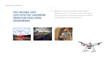
INDUSTRY EXPERTS FAST. RELIABLE. SAFE. COST-EFFECTIVE: UAV/DRONE INSPECTION TOOLS FROM MICRODRONES Power lines. Cell towers. Oil and gas pipelines. Railways. Methane detection – all of these and so many other types of industrial inspection are made easier, safer, and more efficient with Microdrones unmanned aerial systems.
Open the catalog to page 7
THE INDUSTRY’S BEST DRONES FOR LAND DEVELOPMENT AND CONSTRUCTION Offering everything construction companies need to get started, mdMapper and mdLiDAR systems make it easy to: • Create accurate 2D and 3D data, maps, and models. Inspect structures and job sites quickly, safely, and accurately. Conduct surveys – before, during, and after construction. Track volumes and stockpiles. Precisely map roads, canals, pipelines, and other linear infrastructure in one line of flight with no ground control points. Reduce project waste. Easily provide more accurate project estimates. Efficiently gain and share...
Open the catalog to page 8
INDUSTRY EXPERTS THE AERIAL ADVANTAGE FOR AGRICULTURE Microdrones unmanned aerial vehicles are empowering farmers and agronomists across the globe by equipping them with the information they need to identify potential issues and mitigate loss. Our drones offer farmers the longest flight times on the market and resilience in harsh weather. The mdCockpit app simplifies flight planning, monitoring, control, and analysis – and allows you to survey the same field the same way as many times as you wish. Microdrones modular payloads make it easy to swap out to perform a wider variety of applications....
Open the catalog to page 9
INDUSTRY EXPERTS DRONES FOR MINING: QUICK DEPLOYMENT. EXTREME EFFICIENCY. COST SAVINGS. EASE. Microdrones UAVs are taking the global mining industry by storm. Less expensive than the helicopters traditionally used by the industry to gain an aerial perspective, drones are providing mining companies with mapping abilities that provide better results and drastically improved flexibility for a fraction of the cost. Many Microdrones mining customers use our systems to survey mine progress multiple times per day. The mdCockpit app makes it easy to plan, monitor, control and repeat missions and flight...
Open the catalog to page 10
INDUSTRY EXPERTS DRONES FOR SCIENCE AND ACADEMIC RESEARCH Microdrones is honored to partner with researchers around the globe who use our drones to advance human knowledge as they seek solutions to the world’s greatest problems. Microdrones is the trusted UAV of researchers for many reasons, but the two most important are flexibility and performance.
Open the catalog to page 11
INDUSTRY EXPERTS ALWAYS KEEP IN MIND WHAT YOU ARE TRYING TO DO Are you trying to: Survey land for construction projects? Determine volume of material in an open pit mine? Calculate surface run-off? Detect problems with crop health? Minimize waste in administering crop spraying? Inspect structures for wear an
Open the catalog to page 12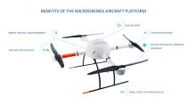
BENEFITS OF THE MICRODRONES AIRCRAFT PLATFORM GNSS receiver GNSS RECEIVER ROBUST HOUSING AND COMPONENTS GNSS receiver FAILSAFE MOTORS FOR MINIMUM RAIN AND HEAT RESISTANT STABLE FLIGHT FOR PRECISE RESULTS
Open the catalog to page 13
DON’T TALK ABOUT EQUIPMENT. Or at least not at first.
Open the catalog to page 14
MORE THAN 1000 BUSINESSES WORLDWIDE TRUST MICRODRONES® Since 2005, our passionate team of aircraft engineers, software developers and payload integration experts have lead the market for professional drone applications.
Open the catalog to page 15
MADE TO DELIVER: RELIABLE TOOLS FOR TOUGH JOBS Surveying, land development, infrastructure inspection, environmental monitoring, precision agriculture, and public safety are done more efficiently and effectively with the help of integrated systems.
Open the catalog to page 16
PROFESSIONAL PEOPLE We have invested in recruiting the best and brightest technology talent worldwide.
Open the catalog to page 17
POSITIONED FOR SUCCESS Microdrones has strategically built a global footprint to efficiently distribute products while providing you the support you need in your market.
Open the catalog to page 18
PACKAGED PRODUCTS THAT PERFORM Our products help you to innovate, to stand out from competitors, to work more safely and efficiently and to use data in a more valuable way.
Open the catalog to page 19All Microdrones catalogs and technical brochures
 PUTTING MICRODRONES TO WORK FOR YOU.
133 Pages