- Catalogs
- Leica Microsystems GmbH
- Leica Map
- Company
- Products
- Catalogs
- News & Trends
- Exhibitions
Leica Map
1 /12Pages

Leica Map
1 /12Pages
Catalog excerpts
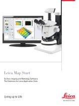
Leica Map Start Surface imaging and Metrology Software. The Extension for Leica Application Suite Living up to Life MICROSYSTEMS
Open the catalog to page 1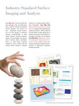
Industry-Standard Surface Imaging and Analysis Leica Map Start is the entry level software package of the Leica Map series and is used for viewing and analyzing surface geometry and surface texture. Capabilities include visualization of all the features of measured surfaces, characterization of basic surface features including distances, angles and step heights, and calculation of surface texture parameters. There is a wide range of optional modules for cases in which more advanced surface analysis is required. Powered by industry-standard Mountains Technology®, Leica Map Start builds detailed...
Open the catalog to page 2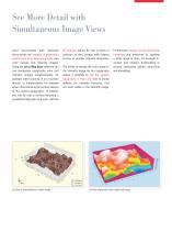
See More Detail with Simultaneous Image Views Leica microscopes with motorized f ocus drives are capable of generating height maps of surface topography, true color images and intensity images. Using the Leica Map Start software you can manipulate topography, color and intensity images simultaneously, for example when zooming in on a surface feature, or independently, for example when characterizing the surface texture of the surface topography. In addition you can fly over a surface following a predefined flight plan and even, with the 3D view of extended focus colour image 4D Analysis option,...
Open the catalog to page 3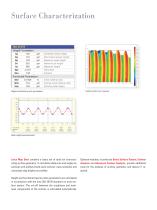
Height and bearing ratio parameters Surface after form removal Step height measurements Optional modules, in particular Basic Surface Texture, Contour Analysis and Advanced Contour Analysis, provide additional tools for the analysis of surface geometry and texture if required. Leica Map Start contains a basic set of tools for characterizing surface geometry. It calculates distances and angles on surfaces and profiles (multi-point vertical cross-sections) and calculates step heights on profiles. Height and functional bearing ratio parameters are calculated in accordance with the new ISO 25178...
Open the catalog to page 4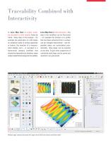
Traceability Combined with Interactivity In Leica Map Start a surface analysis document is built visually, frame by frame. Every step in the analysis – for example the generation of a 3D image, an analytical study of surface geometry or texture, the insertion of a measurement identity card – is recorded in a hierarchical analysis workflow that shows the dependencies between steps and provides full metrological traceability. Leica Map Start is fully interactive. Any step in the workflow can be fine-tuned – for example the location of a profile that has been extracted from a surface can be changed...
Open the catalog to page 5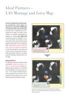
Ideal Partners – LAS Montage and Leica Map A series of image planes at known spacing covering the in focus region of a specimen are acquired by LAS Montage in conjunction with a Leica microscope. From this stack a depthmap and an extended focus image are derived. These images are analyzed automatically by applying an existing Leica Map Start analysis document as a template. In routine environments, the template can be prepared by a metrologist and protected against modification by non-authorized staff. The analysis workflow in the template document is applied automatically to each measurement...
Open the catalog to page 6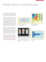
Further Analysis of Surface Texture The Basic Surface Texture optional module provides additional features for the analysis of surface texture. Geometrical studies include the calculation of areas of peaks and valleys on vertical cross-sectional profiles, volumes of bumps and holes, and step heights between zones on surfaces (for example in the assessment of layered electronic and mechanical components, MEMS and electronic circuit boards). Cross-section profile measure area under mean surface Calculation of volume of a manually defined hole Coplanarity of contact zones on an electronic component...
Open the catalog to page 7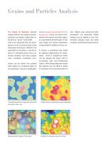
The Grains & Particles optional module detects and analyzes grains, particles and islands (collectively referred to as "grains") and motifs. Grains are separated from the background on the horizontal plane using binarization techniques. Statistics are generated for all grains, a sub-set of grains or individual grains (area, perimeter, diameter, form factor, aspect ratio, roundness, orientation, etc.). Grains can be sorted into subsets with respect to a threshold value on any parameter. This grain topography can be viewed independently from the background. Grains can also be analyzed on the vertical...
Open the catalog to page 8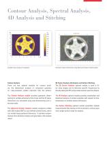
Contour Analysis, Spectral Analysis, 4D Analysis and Stitching Extended focus image of component Horizontal contour dimensions using Advanced Contour Analysis option Contour Analysis 3D Fourier Analysis, 4D Analysis and Surface Stitching There are two optional modules for contour analysis, the dimensional analysis of component geometry on cross-sectional profiles extracted from the surface. The 3D Fourier Analysis optional module is used to filter noisy images and to eliminate specific frequencies by directly editing the FFT and provides tools for spectral analysis. The Contour Analysis module...
Open the catalog to page 9
Instrument compatibility ► The Leica Map Start software is dedicated to Leica microscopes, macroscopes and stereo-microscopes with motorized focus controls and requires LAS Montage software to be installed. PC requirements ► Recommended minimum: Windows 7 or Vista; 4 GB RAM; multi-core processor; 1280x1024 or higher graphics resolution in 32-bit colors. 250 MB disk space; OpenGL accelerated graphics board; USB port for hardware protection key. Desktop publishing environment ► Build a detailed visual metrology report frame by frame in an intuitive desktop publishing environment, working in onscreen,...
Open the catalog to page 10
Basic Surface Texture ► Level surfaces and profiles. ► Calculate the area of peaks and valleys and the volume of bumps and holes. ► Calculate the material/void composition and thickness of up to three vertical surface slices. ► Subtract one surface from another (wear). ► M easure step heights on surfaces. ► Apply ISO 16610 advanced roughness/waviness filtering techniques (robust Gaussian and spline filters). ► Calculate ISO 4287 primary and roughness parameters. Grains & Particles ► Detect grains and particles and separate them from the background on the horizontal axis; generate statistics on...
Open the catalog to page 11All Leica Microsystems GmbH catalogs and technical brochures
 Visoria M flyer
2 Pages
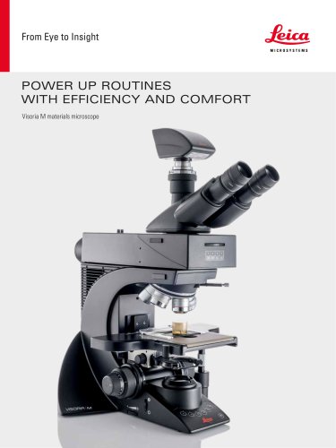 Visoria M brochure
12 Pages
 Mateo FL Flyer EN
2 Pages
 DVM6 Brochure en
16 Pages
 Leica M50, M60, M80
12 Pages
 XL Stand
4 Pages
 LED1000
16 Pages
 LED3000 BLI
20 Pages
 LED5000 NVI
20 Pages
 LED3000 NVI
20 Pages
 LED3000 DI
20 Pages
 LED5000 HDI
20 Pages
 LED5000 CXI
20 Pages
 LED2500
8 Pages
 LED5000 MCI
20 Pages
 LED3000 MCI
20 Pages
 LED5000 SLI
20 Pages
 LED3000 SLI
20 Pages
 LED2000
8 Pages
 LED5000 RL
20 Pages
 LED3000 RL
20 Pages
 EL6000
4 Pages
 M320 F12 for ENT
12 Pages
 M620 TTS
4 Pages
 M220 F12
8 Pages
 RUV800
4 Pages
 DI C800
2 Pages
 M620 F20
8 Pages
 M822 F40 / F20
20 Pages
 M844 F40 / F20
16 Pages
 Proveo 8
16 Pages
 Envisu
8 Pages
 EnFocus
8 Pages
 M525 F20
12 Pages
 FL400
FL4004 Pages
 Leica M525 OH4
20 Pages
 Leica M720 OH5
24 Pages
 Leica M530 OH6
16 Pages
 Leica M530 OHX
16 Pages
 Leica CaptiView
4 Pages
 Leica GLOW800
4 Pages
 Leica ARveo
16 Pages
 Leica PROvido
8 Pages
 LAS X Steel Expert
4 Pages
 Leica LMD Software
16 Pages
 Leica Cleanliness Expert
4 Pages
 Leica LAS X Industry
4 Pages
 Leica LAS X Life Science
4 Pages
 Leica EM CPD300
12 Pages
 Leica EM TP
4 Pages
 Leica EM VCT500
2 Pages
 Leica EM ACE900
12 Pages
 Leica EM ACE200
12 Pages
 Leica EM KMR3
8 Pages
 Leica EM AFS2
8 Pages
 Leica EM ICE
12 Pages
 TCS SP8 DLS
16 Pages
 Leica LIGHTNING
2 Pages
 Leica SP8 DIVE
20 Pages
 Leica K5
2 Pages
 Leica DFC295
6 Pages
 Leica DFC3000 G
6 Pages
 Leica EC4
4 Pages
 Leica DFC7000 T / DFC7000 GT
4 Pages
 Leica DFC9000
2 Pages
 Leica MZ10 F
4 Pages
 Leica M165 FC
16 Pages
 Leica DM IL LED
12 Pages
 Leica DMi1
2 Pages
 THUNDER Imager Tissue
2 Pages
 Leica FS M
12 Pages
 Leica FS C
20 Pages
 Leica FS CB
20 Pages
 Leica DM3000 / DM3000 LED
16 Pages
 Leica DM750
12 Pages
 Leica DM500
12 Pages
 Leica DM300
8 Pages
 Leica DM1750 M
12 Pages
 Leica FS4000 LED
20 Pages
 Leica DM2000 / DM2000 LED
16 Pages
 Leica DM1000
16 Pages
 Leica DM1000 LED
16 Pages
 Leica DM2500 & DM2500 LED
16 Pages
 Leica DM4 B & DM6 B
16 Pages
 Leica DMC2900
6 Pages
 Leica DMC6200
8 Pages
 Leica DMC5400
4 Pages
 Leica Z6 APO
16 Pages
 Leica Z16 APO
16 Pages
 Leica M205 FCA / M205 FA
16 Pages
 Leica DM12000 M
8 Pages
 Leica DM8000 M
8 Pages
 Leica DM4 P, DM2700 P, DM750 P
12 Pages
 Leica EM ACE600
12 Pages
 Leica EM RAPID
8 Pages
 Leica EM TRIM2
8 Pages
 Leica EM TIC 3X
16 Pages
 Leica EM TXP
10 Pages
 Leica DM2700 M
12 Pages
 DMi8 M / C / A
12 Pages
 Leica A60 S / Leica A60 F
16 Pages
 SOLUTIONS FOR MATERIALS SCIENCE
12 Pages
 Leica StereoZoom line
20 Pages
 TL-Bases
12 Pages
 TCS SP8
20 Pages
 TCS SP8 STED 3X
24 Pages
 TCS SP8 Objective
24 Pages
 AOBS
AOBS16 Pages
 Leica DM3 XL
7 Pages
 Leica DMi8 S
12 Pages
 Leica M50/M60/M80
12 Pages
 Leica DM750 M
12 Pages
 Leica DM4 M/ DM6 M
12 Pages
 Leica A60 S/A60 F
16 Pages


- Digital imager
- Visible imager
- CMOS camera module
- Industrial camera module
- Nora LED lighting
- Nora analysis software
- Positioning table
- Nora Windows software
- Full-color camera system
- Translation stage
- USB camera module
- Monochrome camera module
- 3D software solution
- Nora industrial software
- Nora optical microscope
- HD camera module
- LED hand lamp
- Quality software
- Nora laboratory microscope