
- Catalogs
- Leica Geosystems
- Leica ULTRA

Leica ULTRA

Leica ULTRA
The Leica ULTRA is an advanced precision utility tracing system designed to address the increasing complexity of underground utility networks. It provides accurate mapping and surveying of buried utilities to protect assets during excavation work.
- Intelligent Signal Processing: Integrates flexible operating modes to save time and increase confidence in results.
- Ambient Interference Measurement (AIM): Analyzes surrounding noise and recommends optimal frequencies for accurate tracing.
- Offset Measuring: Locates utility lines even when obstructed, estimating horizontal and vertical distances.
- Transmitter to Receiver Link: Allows control of the transmitter from the receiver, enhancing efficiency and reducing time spent on-site.
- Custom Frequencies: Offers over 100 preselected frequencies and the option to customize for specialized applications.
- Data Logging: Captures location data automatically, supporting best practices and integration with GIS systems.
- Large Clear Display: Features a high visibility LCD screen for improved utility tracing.
- Bluetooth® Connectivity: Enables wireless communication with GPS-enabled devices.
- Increased Transmitter Power Output: Options for 5W and 12W outputs for superior performance.
- Built for Demanding Environments: IP65 protection, shock-resistant, and protected against water and dust.
- Selectable Antenna Configuration: Optimizes for specific job sites with various configurations.
- Direction Enabled: Guides users along designated utility paths with directional signals.
The Leica ULTRA is suitable for professionals in industries such as construction, aerospace, defense, safety, and manufacturing, providing precise and accurate geospatial solutions.
Leica Geosystems, part of Hexagon, is a leader in geospatial technology, offering innovative solutions and dependable services for over 200 years.
Catalog excerpts

Leica ULTRA Precision utility tracing
Open the catalog to page 1
Leica ULTRA – Precision locating, for utility tracing The complexity of underground utility networks are continually increasing. So obtaining precise information on the location of buried utilities has never been more important. The protection of buried assets during excavation work demands accurate mapping and surveying of existing utilities. The Leica ULTRA provides our most advanced precision utility tracing system. Intelligent signal processing has been integrated with unique flexible operating modes, to help save you time and increased confidence in your results. Selectable antenna and customised...
Open the catalog to page 2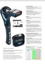
Configure the Leica ULTRA for site specific applications. Custom build your receiver and transmitter. Choose from over 100 preselected frequencies, or customise your own frequency for highly specialised applications. Automatically capture the instruments location data to ensure adherence to best practice. The data logging feature allows the user to record external GPS coordinates and download with the datafile as a KML or CSV format. Upload into GIS systems or Google Maps to confirm where, when and how the work was performed. LARGE CLEAR DISPLAY ■ Large backlit high visibility LCD screen ■ Clear...
Open the catalog to page 3
Leica Geosystems - when it has to be right. Revolutionising the world of measurement and survey for nearly 200 years, Leica Geosystems creates complete solutions for professionals across the planet. Known for valuable products and innovative solution development, professionals in a diverse mix of industries, such as aerospace and defence, safety and security, construction, and manufacturing, trust Leica Geosystems for all their geospatial needs. With precise and accurate instruments, sophisticated software, and dependable services, Leica Geosystems delivers value every day to those shaping the...
Open the catalog to page 4All Leica Geosystems catalogs and technical brochures
 Leica Captivate DS EN
2 Pages
 Leica Pegasus TRK100
4 Pages
 Leica Cyclone 3DR Data Sheet
2 Pages
 Leica GR30 & GR50
4 Pages
 Leica GR30 / GR50 Data Sheet
2 Pages
 Leica LOC8 DS EN
2 Pages
 Leica Rugby CLA-ctive & CLH
2 Pages
 Leica GM30 FLY en
2 Pages
 Leica GM30 DS en
2 Pages
 Leica RTC360 LT Data Sheet
2 Pages
 Leica Flexline TS10 DS EN
2 Pages
 Leica Flexline Series DS EN
2 Pages
 ScanCrete Solution Flyer
2 Pages
 Leica Disto & Leica Lino
32 Pages
 Leica iCON PA10 DS
4 Pages
 Leica PowerBlade Flyer
2 Pages
 Leica MCH100 Flyer
2 Pages
 Leica iCON grade Brochure
8 Pages
 Pegasus Backpack BRO
6 Pages
 Leica Zeno Mobile Data Sheet
2 Pages
 Leica Zeno Connect Flyer
2 Pages
 Pegasus Manager BRO
4 Pages
 Pegasus Swift DS
2 Pages
 Pegasus Swift BRO
6 Pages
 Pegasus Two Ultimate BRO
3 Pages
 Pegasus Two Ultimate DS
2 Pages
 Leica DS2000 starter kit FLY
2 Pages
 Leica Viva GS10 Data Sheet
2 Pages
 Leica Piper Series
2 Pages
 Leica BLK2GO Spec Sheet
2 Pages
 Leica Viva GS14 Data Sheet
2 Pages
 Leica iCONsite foremen
2 Pages
 Leica iCON gps 80 Contractor
6 Pages
 Leica iCON gps 80 OEM
6 Pages
 Leica iCON build
4 Pages
 Leica iCON site Brochure
4 Pages
 Leica GS07 DS EN
2 Pages
 Leica GS18 DS EN
2 Pages
 Leica CS20 DS EN
2 Pages
 Leica CS30 DS EN
2 Pages
 Leica CS35 DS EN
2 Pages
 Leica Infinity Data Sheet
2 Pages
 Leica Viva GS16 Data Sheet
2 Pages
 Leica GS18 I data sheet
2 Pages
 Leica TS16 DS
2 Pages
 Leica TS13 DS EN
2 Pages
 Leica Nova TS60 DS EN
2 Pages
 Leica Nova MS60 DS EN
2 Pages
 Leica FlexLine TS07
1 Page
 Leica ULTRA DS
2 Pages
 Leica ULTRA BRO
4 Pages
 Detection Campus BRO
4 Pages
 Leica TruView Cloud Flyer
2 Pages
 Leica Rugby 600 Series
4 Pages
 Leica Cyclone Cloud Flyer
2 Pages
 Leica CloudWorx for AutoCAD
2 Pages
 Leica iCON gps 60
4 Pages
 Leica iCON gps 70 Series
4 Pages
 Leica M-Com Brochure
4 Pages
 Leica GS18 T GNSS RTK Rover
4 Pages
 Leica ConX Flyer
2 Pages
 Leica Active Assist Flyer
2 Pages
 Leica iCON CC80 Flyer
2 Pages
 Leica iCON roller Flyer
2 Pages
 Leica PowerDigger Lite Flyer
2 Pages
 Leica LS Digital Levels
3 Pages
 Leica GeoMoS Brochure
3 Pages
 Leica AR10
2 Pages
 Leica GM10
2 Pages
 Leica AR25
2 Pages
 Leica GeoMoS Adjustment
2 Pages
 Leica GeoMoS Now
2 Pages
 Leica AR20 Flyer
2 Pages
 Leica Nova TS60
3 Pages
 Leica VADASE
2 Pages
 Leica iCON grade iGG4
4 Pages
 Leica iCON telematics
2 Pages
 AR25 Choke Ring Antenna
2 Pages
 Leica Nova TM50
4 Pages
 Leica TM6100A
6 Pages
 Leica Digicat i-Series
8 Pages
 Leica Absolute Tracker AT402
16 Pages
 Leica T-Scan TS50A brochure
4 Pages
 Leica TDRA6000
8 Pages
 Leica 3D Disto
22 Pages
 Leica Geo Office
3 Pages
 Leica Viva
5 Pages
 Leica SmartWorx Viva
3 Pages
 PROTECT by Leica Geosystems
8 Pages
 Leica Digicat xf-Series
12 Pages
 Leica NA2 / NAK2
8 Pages


Archived catalogs
 Leica Viva GS25 Data Sheet
2 Pages
 Leica Zeno GIS
3 Pages
 Leica Exchange Flyer
2 Pages
 Leica Viva GS15 Data Sheet
2 Pages
 Leica Viva GS15 Brochure
4 Pages
 Leica Nova MS60 Brochure
3 Pages
 Leica Viva TS16 Brochure
3 Pages
 Leica Viva GS16 Brochure
4 Pages
 Leica iCONstruct Software
2 Pages
 Leica iCON CC66
2 Pages
 Leica iCON builder 60
4 Pages
 Leica iCONtrol
4 Pages
 Leica iCON robot 60
4 Pages
 Leica iCON robot 50
2 Pages
 Leica Infinity Brochure
4 Pages
 Leica FlexLine TS02plus
2 Pages
 Leica Zeno 20 Brochure
5 Pages
 Leica DX Manager Flyer
2 Pages
 Leica Detection Campus
2 Pages
 Leica Detection Solutions
4 Pages
 Construction Catalogue
84 Pages
 Leica MultiWorx Data Sheet
2 Pages


- Digital imager
- Management software solution
- Automation software solution
- Process software
- Real-time software
- Windows software
- Computer-aided design software
- Cloud-based software
- Control software
- Touch screen tablet
- Wireless tablet
- Design software solution
- Monitoring software solution
- Rugged tablet
- 3D software solution
- Measurement software
- Interface software
- WiFi tablet
- Visualization software solution
- Quality software