- Catalogs
- Leica Geosystems
- Leica GR10 Plug & Play GNSS Reference Station
Leica GR10 Plug & Play GNSS Reference Station
1 /8Pages

Leica GR10 Plug & Play GNSS Reference Station
1 /8Pages
Catalog excerpts

Plug & Play GNSS Reference Station
Open the catalog to page 1
Leica GR10 GNSS Receiver Streamlined Designed for a wide variety of GNSS Reference Station applications, the Leica GR10 offers new levels of simplicity, reliability and performance. With a focus on ease of use and efficiency, the GR10 helps streamline day to day operation and administration. The GR10 provides excellent low noise code and phase data with logging and streaming rates up to 50 Hz. The powerful onboard RefWorx software features flexible data handling and communication, ensuring high performance and secure long term operation. GNSS Unlimited Series Safe investment with the GNSS Unlimited...
Open the catalog to page 2
SmartTrack+ The GR10 is able to simultaneously observe up to 60 satellites for all in view tracking. The GR10 allows parallel tracking of multiple signals per satellite for all supported GNSS. Smart Logging Create up to 12 parallel logging sessions, using MDB, RINEX and Hatanaka, including zip compression and data rates up to 50 Hz. Supports removable SD card based storage up to 32 GB and FTP push to multiple locations. Smart Clean-up Prioritized clean up of data allows full usage of the available storage space and ensures the most important data is preserved in case capacity is reached. Up to...
Open the catalog to page 3
Leica GR10 GNSS Receiver Straightforward The intelligent RefWorx software has an intuitive and straightforward workflow so that status and configuration can be checked and updated easily. Simply plug the GR10 into your network and start working – no pre-configuration is needed! All status and configuration options are available via the brand new web interface. Should you need assistance, tool tips, hints and built-in comprehensive online help are only a click away. Easy Installation The GR10 is designed for straightforward installation and offers various mounting options including IT rack, wall...
Open the catalog to page 4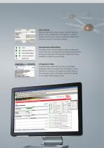
Easy Setup Plug and play setup using a unique receiver hostname means no pre-configuration of IP address is needed. Simply connect to the Local Area Network (LAN) or the USB port on your PC and start working! t| © 4 active data streams) Streamlined Workflow The state-of-the-art web interface makes configuration easier than ever, reducing time and training requirements. Key status information including the unique event log is available at a glance on every page. Integrated Help Comprehensive online help, tool tips and multiple languages make the receiver easy to manage. In case assistance is required,...
Open the catalog to page 5
Leica GR10 GNSS Receiver Secure Featuring a strong security concept, robust software design and built in tools for backup, restore and system monitoring, the GR10 offers reliable and uninterupted operation. Designed for High Security The viewer/manager/administrator user levels and web interface restrictions together with HTTPs and SSL encryption prevent unauthorised access to the receiver. The integrated firewall and IP address filtering provide additional layers of security. High Reliability An integrated watchdog service ensures quality of service and maximises uptime, giving you extra peace...
Open the catalog to page 6
Technical Specifications Leica GR10 GNSS technology Leica patented SmartTrack+ technology: Very low noise GNSS carrier phase measurements with <0.2 mm (rms) precision Fixed RTK positioning accuracy 10 mm + 1 ppm (rms) horizontal / 20 mm + 1 ppm (rms) vertical High precision pulse aperture multipath correlator for pseudorange measurements Excellent low elevation tracking, fast aquisition time and jamming resistant GNSS Signals Flexible configuration with up to 60 Satellites, 7 Signals per Satellite 1, 120/500+2 Channels: GPS: L1 C/A, L2P, L2C, L5 GLONASS: L1 C/A, L2P, L2C Galileo: E1, E5a, E5b,...
Open the catalog to page 7
Whether providing corrections from just a single reference station, or an extensive range of services from a nationwide RTK network – innovative reference station solutions from Leica Geosystems offer tailor-made yet scalable systems, designed for minimum operator interaction whilst providing maximum user benefit. In full compliance with international standards, Leica Geosystems’ proven and reliable solutions are based on the latest technology. Precision, value, and service from Leica Geosystems. When it has to be right. Illustrations, descriptions and technical data are not binding. All rights...
Open the catalog to page 8All Leica Geosystems catalogs and technical brochures
 Leica Captivate DS EN
2 Pages
 Leica Pegasus TRK100
4 Pages
 Leica Cyclone 3DR Data Sheet
2 Pages
 Leica GR30 & GR50
4 Pages
 Leica GR30 / GR50 Data Sheet
2 Pages
 Leica LOC8 DS EN
2 Pages
 Leica Rugby CLA-ctive & CLH
2 Pages
 Leica GM30 FLY en
2 Pages
 Leica GM30 DS en
2 Pages
 Leica RTC360 LT Data Sheet
2 Pages
 Leica Flexline TS10 DS EN
2 Pages
 Leica Flexline Series DS EN
2 Pages
 ScanCrete Solution Flyer
2 Pages
 Leica Disto & Leica Lino
32 Pages
 Leica iCON PA10 DS
4 Pages
 Leica PowerBlade Flyer
2 Pages
 Leica MCH100 Flyer
2 Pages
 Leica iCON grade Brochure
8 Pages
 Pegasus Backpack BRO
6 Pages
 Leica Zeno Mobile Data Sheet
2 Pages
 Leica Zeno Connect Flyer
2 Pages
 Pegasus Manager BRO
4 Pages
 Pegasus Swift DS
2 Pages
 Pegasus Swift BRO
6 Pages
 Pegasus Two Ultimate BRO
3 Pages
 Pegasus Two Ultimate DS
2 Pages
 Leica DS2000 starter kit FLY
2 Pages
 Leica Viva GS10 Data Sheet
2 Pages
 Leica Piper Series
2 Pages
 Leica BLK2GO Spec Sheet
2 Pages
 Leica Viva GS14 Data Sheet
2 Pages
 Leica iCONsite foremen
2 Pages
 Leica iCON gps 80 Contractor
6 Pages
 Leica iCON gps 80 OEM
6 Pages
 Leica iCON build
4 Pages
 Leica iCON site Brochure
4 Pages
 Leica GS07 DS EN
2 Pages
 Leica GS18 DS EN
2 Pages
 Leica CS20 DS EN
2 Pages
 Leica CS30 DS EN
2 Pages
 Leica CS35 DS EN
2 Pages
 Leica Infinity Data Sheet
2 Pages
 Leica Viva GS16 Data Sheet
2 Pages
 Leica GS18 I data sheet
2 Pages
 Leica TS16 DS
2 Pages
 Leica TS13 DS EN
2 Pages
 Leica Nova TS60 DS EN
2 Pages
 Leica Nova MS60 DS EN
2 Pages
 Leica FlexLine TS07
1 Page
 Leica ULTRA DS
2 Pages
 Leica ULTRA BRO
4 Pages
 Detection Campus BRO
4 Pages
 Leica TruView Cloud Flyer
2 Pages
 Leica Rugby 600 Series
4 Pages
 Leica Cyclone Cloud Flyer
2 Pages
 Leica CloudWorx for AutoCAD
2 Pages
 Leica iCON gps 60
4 Pages
 Leica iCON gps 70 Series
4 Pages
 Leica M-Com Brochure
4 Pages
 Leica GS18 T GNSS RTK Rover
4 Pages
 Leica ConX Flyer
2 Pages
 Leica Active Assist Flyer
2 Pages
 Leica iCON CC80 Flyer
2 Pages
 Leica iCON roller Flyer
2 Pages
 Leica PowerDigger Lite Flyer
2 Pages
 Leica LS Digital Levels
3 Pages
 Leica GeoMoS Brochure
3 Pages
 Leica AR10
2 Pages
 Leica GM10
2 Pages
 Leica AR25
2 Pages
 Leica GeoMoS Adjustment
2 Pages
 Leica GeoMoS Now
2 Pages
 Leica AR20 Flyer
2 Pages
 Leica Nova TS60
3 Pages
 Leica VADASE
2 Pages
 Leica iCON grade iGG4
4 Pages
 Leica iCON telematics
2 Pages
 AR25 Choke Ring Antenna
2 Pages
 Leica Nova TM50
4 Pages
 Leica TM6100A
6 Pages
 Leica Digicat i-Series
8 Pages
 Leica Absolute Tracker AT402
16 Pages
 Leica T-Scan TS50A brochure
4 Pages
 Leica TDRA6000
8 Pages
 Leica 3D Disto
22 Pages
 Leica Geo Office
3 Pages
 Leica Viva
5 Pages
 Leica SmartWorx Viva
3 Pages
 PROTECT by Leica Geosystems
8 Pages
 Leica Digicat xf-Series
12 Pages
 Leica NA2 / NAK2
8 Pages


Archived catalogs
 Leica Viva GS25 Data Sheet
2 Pages
 Leica Zeno GIS
3 Pages
 Leica Exchange Flyer
2 Pages
 Leica Viva GS15 Data Sheet
2 Pages
 Leica Viva GS15 Brochure
4 Pages
 Leica Nova MS60 Brochure
3 Pages
 Leica Viva TS16 Brochure
3 Pages
 Leica Viva GS16 Brochure
4 Pages
 Leica iCONstruct Software
2 Pages
 Leica iCON CC66
2 Pages
 Leica iCON builder 60
4 Pages
 Leica iCONtrol
4 Pages
 Leica iCON robot 60
4 Pages
 Leica iCON robot 50
2 Pages
 Leica Infinity Brochure
4 Pages
 Leica FlexLine TS02plus
2 Pages
 Leica Zeno 20 Brochure
5 Pages
 Leica DX Manager Flyer
2 Pages
 Leica Detection Campus
2 Pages
 Leica Detection Solutions
4 Pages
 Leica ULTRA
4 Pages
 Construction Catalogue
84 Pages
 Leica MultiWorx Data Sheet
2 Pages


- Digital imager
- Management software solution
- Automation software solution
- Process software
- Windows software
- Real-time software
- Computer-aided design software
- Cloud-based software
- Control software
- Touch screen tablet
- Wireless tablet
- Design software solution
- Rugged tablet
- Monitoring software solution
- 3D software solution
- Interface software
- Measurement software
- WiFi tablet
- Quality software
- Visualization software solution