- Catalogs
- Leica Geosystems
- Leica Geosystems Construction Technical Specification Booklet
Leica Geosystems Construction Technical Specification Booklet
1 /19Pages

Leica Geosystems Construction Technical Specification Booklet
1 /19Pages
Catalog excerpts

Leica Geosystems Construction Tools Technical Specifications
Open the catalog to page 1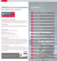
PROTECT by Leica Geosystems We protect your success Lifetime Manufacturer’s Warranty PROTECT by Leica Geosystems Optical Levels Warranty coverage for the entire usage time of the product, in accordance with the Leica Geosystems International Limited Warranty. This includes free of charge repair or replacement for all products that suffer defects as a result of faults in materials or manufacturing. No Cost Period Guaranteed best-in-class service should your product become defective or require servicing under normal conditions of use, as described in the user manual, at no additional charge to...
Open the catalog to page 2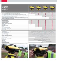
Digital Levels Applications Error-free levelling for basic work on any construction site Error-free levelling for applications supported by onboard calculations on any construction site For advanced construction levelling tasks with demand for data storage and transfer e.g. civil engineering and construction surveying For advanced construction levelling tasks with demand for higher accuracy e.g. civil engineering and construction surveying Features Optical staff reading Automatic staff reading Inverse staff reading Height & distance measurement Delta height Multilingual function Tracking Cut...
Open the catalog to page 4
Line & Dot Lasers Technical data Range* Range with laser receiver* Levelling accuracy Self-levelling range Up, down, forward, right, left 2 Vertical, horizontal up, down, right, left Vertical, horizontal Horizontal line accuracy Vertical accuracy Battery life Battery type NiMH rechargeable battery pack Type AA 3 × 1.5 V Up to 8 hours (alkaline) Environmental standard Weight with batteries Tripod thread Number of laser lines Laser type Number of laser points Beam direction * Depending on lighting conditions
Open the catalog to page 5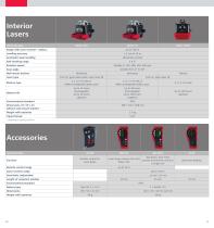
Interior Lasers Technical data Range with laser receiver* (radius) Levelling accuracy Automatic laser levelling Horizontal, vertical Self-levelling range Rotation speed Scan angle Wall mount bracket Laser type Battery type Battery life Variable from 2° to 36° Motorised 532 nm, green laser beam, laser class 3R 2 x 1.5 V D-cells or NiMH rechargeable battery pack 2 x 1.5 V D-cells or NiMH rechargeable battery pack Up to 25 hours (rechargeable) Up to 40 hours (alkaline) Up to 50 hours (rechargeable) Up to 160 hours (alkaline) Environmental standard Dimensions (H × W × D) without wall mount bracket...
Open the catalog to page 6
Construction Lasers Applications General construction, excavations, forms and footings Site preparation, parking lots, sport fields Interior construction, layout, walls and ceilings Machine control of excavators, graders, dozers, etc. Applications with slopes Technical data Self-levelling horizontal, single manual slope (with slope adapter) Self-levelling horizontal, with dual axis manual slope Self-levelling horizontal, vertical, 90° with dual axis manual slope Self-levelling horizontal, with dial-in, single axis, semi-auto slope Self-levelling horizontal, with dial-in, dual axis, semi-auto...
Open the catalog to page 7
Construction Lasers Applications General construction, excavations, forms and footings Site preparation, parking lots, sport fields Interior construction, layout, walls and ceilings Machine control of excavators, graders, dozers, etc. Agricultural applications: land levelling Technical data Functionality Self-levelling horizontal, single manual slope (with slope adapter) Self-levelling horizontal, with dual axis manual slope Self-levelling horizontal, with dual axis manual slope Self-levelling horizontal, vertical, 90° with dual axis manual slope Smart Targeting Smart Lock Maximum temperature...
Open the catalog to page 8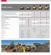
Grade Lasers Applications General construction: excavators, footing, concrete forming Civil engineering: parking lots, runways, sports fields Installing septic and gravity flow pipes for drainage Machine control of excavators, graders, dozers and similiar equipment Agricultural applications such as land levelling or tilling Technical data Environmental standard High-impact composite housing Elevation alert Scan modes Remote control Grade entry with display Dual grade Two-year knockdown warranty Range (Diameter) Accuracy Self-levelling accuracy Grade capability Battery type Battery life Weight...
Open the catalog to page 9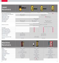
Laser Receivers Technical data Smart Targeting, Smart Lock Working diameter (laser dependent) Detection window Digital readout / height Digital readout / units Detectable spectrum Automatic shutoff Audio volumes Arrow display Five channels Nine channels High / Med / Low / Off Fifteen channels Very fine ± 0.5 mm (± 0.02") Fine ± 1 mm (± 0.04") Detection accuracies Medium ± 2 mm (± 0.08") Coarse ± 3 mm (± 0.12") Very Coarse ± 5 mm (± 0.20") LED display Anti-strobe protection Memory, last beam strike Beam finding, double beep Laser low battery indicator Environmental standard Battery life (hours)...
Open the catalog to page 10
Cable Locators Technical data Power mode Radio mode Auto mode Power + Radio mode Power + Radio mode 640 Hz mode Typical detection range Typical detection range (8 kHz, 33 kHz 512 kHz, 640 kHz) Dependant on signal transmitter or Digimouse (sonde) Dependant on signal transmitter or Digimouse (sonde) Depth estimation - Line mode Depth estimation - Sonde mode Environmental standard Operating temperature range Bluetooth® Battery type Battery life Weight Dimensions Built-in memory to record usage 32 MB memory (CSV file compatibility program) 32 MB memory (CSV file compatibility program) 32 MB memory...
Open the catalog to page 11
Signal Transmitters & Accessories Technical data Signal Clamp Property Connection 640 Hz mode Induction (Watts max.) Direct connection (Watts max.) When connected to a buried utility with an impedance of 300 Ohms Environmental standard Environmental standard with case closed Environmental standard with case open 4 x D-cell alkaline (IEC LR20), supplied 4 x D-cell alkaline (IEC LR20), supplied Operating temperature range Battery type Battery life (Typical use at 20 °C) 40 hrs intermittent use at 20 °C (68 °F) in 8 kHz mode or 33 kHz mode Frame 490 mm (H) x 210 mm (D) x 440 mm (W), 6 mm rod diameter,...
Open the catalog to page 12All Leica Geosystems catalogs and technical brochures
 Leica Captivate DS EN
2 Pages
 Leica Pegasus TRK100
4 Pages
 Leica Cyclone 3DR Data Sheet
2 Pages
 Leica GR30 & GR50
4 Pages
 Leica GR30 / GR50 Data Sheet
2 Pages
 Leica LOC8 DS EN
2 Pages
 Leica Rugby CLA-ctive & CLH
2 Pages
 Leica GM30 FLY en
2 Pages
 Leica GM30 DS en
2 Pages
 Leica RTC360 LT Data Sheet
2 Pages
 Leica Flexline TS10 DS EN
2 Pages
 Leica Flexline Series DS EN
2 Pages
 ScanCrete Solution Flyer
2 Pages
 Leica Disto & Leica Lino
32 Pages
 Leica iCON PA10 DS
4 Pages
 Leica PowerBlade Flyer
2 Pages
 Leica MCH100 Flyer
2 Pages
 Leica iCON grade Brochure
8 Pages
 Pegasus Backpack BRO
6 Pages
 Leica Zeno Mobile Data Sheet
2 Pages
 Leica Zeno Connect Flyer
2 Pages
 Pegasus Manager BRO
4 Pages
 Pegasus Swift DS
2 Pages
 Pegasus Swift BRO
6 Pages
 Pegasus Two Ultimate BRO
3 Pages
 Pegasus Two Ultimate DS
2 Pages
 Leica DS2000 starter kit FLY
2 Pages
 Leica Viva GS10 Data Sheet
2 Pages
 Leica Piper Series
2 Pages
 Leica BLK2GO Spec Sheet
2 Pages
 Leica Viva GS14 Data Sheet
2 Pages
 Leica iCONsite foremen
2 Pages
 Leica iCON gps 80 Contractor
6 Pages
 Leica iCON gps 80 OEM
6 Pages
 Leica iCON build
4 Pages
 Leica iCON site Brochure
4 Pages
 Leica GS07 DS EN
2 Pages
 Leica GS18 DS EN
2 Pages
 Leica CS20 DS EN
2 Pages
 Leica CS30 DS EN
2 Pages
 Leica CS35 DS EN
2 Pages
 Leica Infinity Data Sheet
2 Pages
 Leica Viva GS16 Data Sheet
2 Pages
 Leica GS18 I data sheet
2 Pages
 Leica TS16 DS
2 Pages
 Leica TS13 DS EN
2 Pages
 Leica Nova TS60 DS EN
2 Pages
 Leica Nova MS60 DS EN
2 Pages
 Leica FlexLine TS07
1 Page
 Leica ULTRA DS
2 Pages
 Leica ULTRA BRO
4 Pages
 Detection Campus BRO
4 Pages
 Leica TruView Cloud Flyer
2 Pages
 Leica Rugby 600 Series
4 Pages
 Leica Cyclone Cloud Flyer
2 Pages
 Leica CloudWorx for AutoCAD
2 Pages
 Leica iCON gps 60
4 Pages
 Leica iCON gps 70 Series
4 Pages
 Leica M-Com Brochure
4 Pages
 Leica GS18 T GNSS RTK Rover
4 Pages
 Leica ConX Flyer
2 Pages
 Leica Active Assist Flyer
2 Pages
 Leica iCON CC80 Flyer
2 Pages
 Leica iCON roller Flyer
2 Pages
 Leica PowerDigger Lite Flyer
2 Pages
 Leica LS Digital Levels
3 Pages
 Leica GeoMoS Brochure
3 Pages
 Leica AR10
2 Pages
 Leica GM10
2 Pages
 Leica AR25
2 Pages
 Leica GeoMoS Adjustment
2 Pages
 Leica GeoMoS Now
2 Pages
 Leica AR20 Flyer
2 Pages
 Leica Nova TS60
3 Pages
 Leica VADASE
2 Pages
 Leica iCON grade iGG4
4 Pages
 Leica iCON telematics
2 Pages
 AR25 Choke Ring Antenna
2 Pages
 Leica Nova TM50
4 Pages
 Leica TM6100A
6 Pages
 Leica Digicat i-Series
8 Pages
 Leica Absolute Tracker AT402
16 Pages
 Leica T-Scan TS50A brochure
4 Pages
 Leica TDRA6000
8 Pages
 Leica 3D Disto
22 Pages
 Leica Geo Office
3 Pages
 Leica Viva
5 Pages
 Leica SmartWorx Viva
3 Pages
 PROTECT by Leica Geosystems
8 Pages
 Leica Digicat xf-Series
12 Pages
 Leica NA2 / NAK2
8 Pages


Archived catalogs
 Leica Viva GS25 Data Sheet
2 Pages
 Leica Zeno GIS
3 Pages
 Leica Exchange Flyer
2 Pages
 Leica Viva GS15 Data Sheet
2 Pages
 Leica Viva GS15 Brochure
4 Pages
 Leica Nova MS60 Brochure
3 Pages
 Leica Viva TS16 Brochure
3 Pages
 Leica Viva GS16 Brochure
4 Pages
 Leica iCONstruct Software
2 Pages
 Leica iCON CC66
2 Pages
 Leica iCON builder 60
4 Pages
 Leica iCONtrol
4 Pages
 Leica iCON robot 60
4 Pages
 Leica iCON robot 50
2 Pages
 Leica Infinity Brochure
4 Pages
 Leica FlexLine TS02plus
2 Pages
 Leica Zeno 20 Brochure
5 Pages
 Leica DX Manager Flyer
2 Pages
 Leica Detection Campus
2 Pages
 Leica Detection Solutions
4 Pages
 Leica ULTRA
4 Pages
 Construction Catalogue
84 Pages
 Leica MultiWorx Data Sheet
2 Pages


- Digital imager
- Management software solution
- Automation software solution
- Process software
- Windows software
- Real-time software
- Computer-aided design software
- Cloud-based software
- Control software
- Touch screen tablet
- Wireless tablet
- Design software solution
- Rugged tablet
- Monitoring software solution
- 3D software solution
- Interface software
- Measurement software
- WiFi tablet
- Quality software
- Visualization software solution