- Catalogs
- Leica Geosystems
- Leica Cyclone MODEL Data Sheet
Leica Cyclone MODEL Data Sheet
1 /2Pages

Leica Cyclone MODEL Data Sheet
1 /2Pages
Catalog excerpts
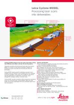
Leica Cyclone MODEL Processing laser scans into deliverables The meshed ground surface is shown displayed with colours mapped by elevation A detailed plant model is integrated with structure and ground surface models Users can easily model buildings, roads, structures, bridges, light poles and more Creating modeled objects from your point cloud data to bring new efficiency and utility to all your 2D and 3D projects. Unmatched versatility and performance help make Leica Cyclone MODEL the industry’s most popular standalone software for analysing rich point cloud data and converting the data into deliverables. Cyclone MODEL boasts powerful visualisation and point cloud navigation plus the industry’s most complete tool set for modeling and survey workflows. These tools can be applied to 3D projects spanning applications in engineering, construction, asset management, heritage, forensics, and other areas. Cyclone MODEL provides unmatched office productivity, automating many time-consuming tasks. Cyclone MODEL reflects the data quality and accuracy advantages that users worldwide expect from Leica Geosystems. Features and Benefits: nnFloor Flatness/Floor Levelness tool that automatically calculates a report according to ASTM1155 standard nnImport of Cyclone REGISTER 360 Projects nn3D navigation and “fly mode” with 3D mouse support nnDirect import of Leica Pegasus project data, including device trajectories for easy TruView creation along device tracks nnDirect import of DotProduct *.dp files nnBatch import of iSTAR and Spheron panoramic images nnTexture mapping with Auto-Align panos to scans, supporting iSTAR, Spheron, and Nodal Ninja workflows nnTexture mapping with HDR Tone Map editor nnMultiple, fast, convenient visualisation modes nnOrtho Image Extraction nnPublish COE to Cyclone MODEL VR (with Cyclone MODEL VR PUBLISHER License) nnCreate GeoTags nnView assets from imported Leica RTC360 projects Plant & building tools include: nnBest-fit modelling, catalogue fitting, clash detection nnAuto Pipe Finder and Pipe Run Finder - automatically find and fit cylinders Civil & related tools include: nnData collector emulation nnCreate contours, breaklines, COGO points, cross sections nnTIN/mesh creation, volumes, areas, clear
Open the catalog to page 1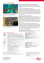
Leica Cyclone MODEL High-performance modelling for a wide range of applications Accurately model a selected geometry type, such as pipes, planes, and topographic surfaces. Least-squares fitting and quality-of-fit statistics ensure reliable results, while Cyclone’s advanced memory management provides high performance. The automated Pipe Run feature lets users select points on connected, straight pipe sections, and the system automatically models a best fit pipe run with elbows in seconds. Industry first robust steel fitter that automatically places catalogue steel shapes quickly and accurately....
Open the catalog to page 2All Leica Geosystems catalogs and technical brochures
 Leica Captivate DS EN
2 Pages
 Leica Pegasus TRK100
4 Pages
 Leica Cyclone 3DR Data Sheet
2 Pages
 Leica GR30 & GR50
4 Pages
 Leica GR30 / GR50 Data Sheet
2 Pages
 Leica LOC8 DS EN
2 Pages
 Leica Rugby CLA-ctive & CLH
2 Pages
 Leica GM30 FLY en
2 Pages
 Leica GM30 DS en
2 Pages
 Leica RTC360 LT Data Sheet
2 Pages
 Leica Flexline TS10 DS EN
2 Pages
 Leica Flexline Series DS EN
2 Pages
 ScanCrete Solution Flyer
2 Pages
 Leica Disto & Leica Lino
32 Pages
 Leica iCON PA10 DS
4 Pages
 Leica PowerBlade Flyer
2 Pages
 Leica MCH100 Flyer
2 Pages
 Leica iCON grade Brochure
8 Pages
 Pegasus Backpack BRO
6 Pages
 Leica Zeno Mobile Data Sheet
2 Pages
 Leica Zeno Connect Flyer
2 Pages
 Pegasus Manager BRO
4 Pages
 Pegasus Swift DS
2 Pages
 Pegasus Swift BRO
6 Pages
 Pegasus Two Ultimate BRO
3 Pages
 Pegasus Two Ultimate DS
2 Pages
 Leica DS2000 starter kit FLY
2 Pages
 Leica Viva GS10 Data Sheet
2 Pages
 Leica Piper Series
2 Pages
 Leica BLK2GO Spec Sheet
2 Pages
 Leica Viva GS14 Data Sheet
2 Pages
 Leica iCONsite foremen
2 Pages
 Leica iCON gps 80 Contractor
6 Pages
 Leica iCON gps 80 OEM
6 Pages
 Leica iCON build
4 Pages
 Leica iCON site Brochure
4 Pages
 Leica GS07 DS EN
2 Pages
 Leica GS18 DS EN
2 Pages
 Leica CS20 DS EN
2 Pages
 Leica CS30 DS EN
2 Pages
 Leica CS35 DS EN
2 Pages
 Leica Infinity Data Sheet
2 Pages
 Leica Viva GS16 Data Sheet
2 Pages
 Leica GS18 I data sheet
2 Pages
 Leica TS16 DS
2 Pages
 Leica TS13 DS EN
2 Pages
 Leica Nova TS60 DS EN
2 Pages
 Leica Nova MS60 DS EN
2 Pages
 Leica FlexLine TS07
1 Page
 Leica ULTRA DS
2 Pages
 Leica ULTRA BRO
4 Pages
 Detection Campus BRO
4 Pages
 Leica TruView Cloud Flyer
2 Pages
 Leica Rugby 600 Series
4 Pages
 Leica Cyclone Cloud Flyer
2 Pages
 Leica CloudWorx for AutoCAD
2 Pages
 Leica iCON gps 60
4 Pages
 Leica iCON gps 70 Series
4 Pages
 Leica M-Com Brochure
4 Pages
 Leica GS18 T GNSS RTK Rover
4 Pages
 Leica ConX Flyer
2 Pages
 Leica Active Assist Flyer
2 Pages
 Leica iCON CC80 Flyer
2 Pages
 Leica iCON roller Flyer
2 Pages
 Leica PowerDigger Lite Flyer
2 Pages
 Leica LS Digital Levels
3 Pages
 Leica GeoMoS Brochure
3 Pages
 Leica AR10
2 Pages
 Leica GM10
2 Pages
 Leica AR25
2 Pages
 Leica GeoMoS Adjustment
2 Pages
 Leica GeoMoS Now
2 Pages
 Leica AR20 Flyer
2 Pages
 Leica Nova TS60
3 Pages
 Leica VADASE
2 Pages
 Leica iCON grade iGG4
4 Pages
 Leica iCON telematics
2 Pages
 AR25 Choke Ring Antenna
2 Pages
 Leica Nova TM50
4 Pages
 Leica TM6100A
6 Pages
 Leica Digicat i-Series
8 Pages
 Leica Absolute Tracker AT402
16 Pages
 Leica T-Scan TS50A brochure
4 Pages
 Leica TDRA6000
8 Pages
 Leica 3D Disto
22 Pages
 Leica Geo Office
3 Pages
 Leica Viva
5 Pages
 Leica SmartWorx Viva
3 Pages
 PROTECT by Leica Geosystems
8 Pages
 Leica Digicat xf-Series
12 Pages
 Leica NA2 / NAK2
8 Pages


Archived catalogs
 Leica Viva GS25 Data Sheet
2 Pages
 Leica Zeno GIS
3 Pages
 Leica Exchange Flyer
2 Pages
 Leica Viva GS15 Data Sheet
2 Pages
 Leica Viva GS15 Brochure
4 Pages
 Leica Nova MS60 Brochure
3 Pages
 Leica Viva TS16 Brochure
3 Pages
 Leica Viva GS16 Brochure
4 Pages
 Leica iCONstruct Software
2 Pages
 Leica iCON CC66
2 Pages
 Leica iCON builder 60
4 Pages
 Leica iCONtrol
4 Pages
 Leica iCON robot 60
4 Pages
 Leica iCON robot 50
2 Pages
 Leica Infinity Brochure
4 Pages
 Leica FlexLine TS02plus
2 Pages
 Leica Zeno 20 Brochure
5 Pages
 Leica DX Manager Flyer
2 Pages
 Leica Detection Campus
2 Pages
 Leica Detection Solutions
4 Pages
 Leica ULTRA
4 Pages
 Construction Catalogue
84 Pages
 Leica MultiWorx Data Sheet
2 Pages


- Digital imager
- Management software solution
- Automation software solution
- Process software
- Windows software
- Real-time software
- Computer-aided design software
- Cloud-based software
- Control software
- Touch screen tablet
- Wireless tablet
- Design software solution
- Rugged tablet
- Monitoring software solution
- 3D software solution
- Interface software
- Measurement software
- WiFi tablet
- Quality software
- Visualization software solution