
- Catalogs
- Leica Geosystems
- Leica Cyclone FIELD 360 Data Sheet

Leica Cyclone FIELD 360 Data Sheet

Leica Cyclone FIELD 360 Data Sheet
The Leica Cyclone FIELD 360 is a mobile app designed to complement Leica Geosystems' 3D reality capture solutions. It supports various laser scanners including BLK360, BLK2GO, BLK ARC, RTC360, and ScanStation P-Series. The app offers an intuitive interface for remote scanner control and on-site point cloud display, making it accessible even for novice users.
Key Features
- Scanner Control: Provides remote control access to all scanner features.
- Data Management: Allows creation, editing, and deletion of scan jobs.
- Data Communication & Transfer: Supports bi-directional wireless communication and automatic data transfer between scanner and tablet.
- Quality Control: Facilitates navigation and display of point clouds in various views, and supports live scanner positioning.
- Data Tagging: Enables tagging of images, videos, voice, text, and other files to point cloud data.
- Pre-Registration: Utilizes Visual Inertial System (VIS) technology for automated cloud-to-cloud registration.
- Add-Ons: Includes Quick Plan for extracting walls and creating floor plan models.
Interoperability
The app is compatible with various Leica hardware and software, including the Leica Cyclone REGISTER 360 PLUS and TruView Cloud. It requires specific system requirements for Android and iOS devices.
System Requirements
- Android: Requires Android 10.0 or higher with 64-bit ARM architecture and at least 4GB of RAM. Recommended devices include Samsung Galaxy Tab S8, S9, and Galaxy S22, S23 series.
- iOS: Requires iOS 16 or higher with 64-bit operating system and at least 4GB of RAM. Recommended devices include iPad Pro 11 (2021, 2022) and iPhone 13, 14, 15 series.
Conclusion
The Leica Cyclone FIELD 360 app enhances field productivity by providing robust tools for data management, quality control, and interoperability with Leica's suite of 3D reality capture solutions.
Catalog excerpts
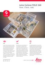
Leica Cyclone FIELD 360 View. Check. Add. As part of Leica Geosystems’ 3D reality capture solutions, the high-performance Leica Cyclone FIELD 360 mobile-device app is the perfect field companion for the BLK360, BLK2GO, BLK2GO PULSE, BLK ARC, RTC360 and ScanStation P-Series laser scanners. With its intuitive user interface, remote scanner control and on-site point cloud display, navigation is a breeze - even for novice users – with full imagery and point cloud Direct data access and visualisation are the foundation for quality control in the field; with Cyclone FIELD 360, prealigned point cloud data enables users to quickly conduct on-site quality control checks, improves productivity, and makes for better-informed decisions in the field. Directly publish your captured data from Cyclone FIELD 360 to TruView Cloud or Reality Cloud Studio, powered by HxDR to quickly exchange project information For improved registration in Leica Cyclone REGISTER 360 PLUS post-processing, and to add extra value and information to 3D data, Cyclone FIELD 360 enables on-site tagging of measurements, videos, images, text or voice files to the point cloud geometry simply by using your tablet or smartphone. Using the Quick Plan add-on, extract walls to build rooms, define windows and doors and create a floor plan model shared directly in the field or consumed by Cyclone data delivered directly to your tablet or smartphone using edge computing technology. between the office and the field prior to import and registration. office software.
Open the catalog to page 1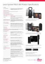
Leica Cyclone FIELD 360 Product Specifications GENERAL iOS or Android app In-the-field app for remote scanner control, data management, quality control, data tagging and automatic pre-registration on-site SCANNER CONTROL Remote scanner control with access to all control features DATA MANAGEMENT Create, edit and delete scan jobs DATA COMMUNICATION & TRANSFER Communication Bi-directional wireless communication between scanner and tablet Automatic transfer of scan data from scanner to tablet; automatic synchronisation of all app created data from tablet to the scanner Publishing to Reality Cloud...
Open the catalog to page 2All Leica Geosystems catalogs and technical brochures
 Leica Captivate DS EN
2 Pages
 Leica Pegasus TRK100
4 Pages
 Leica Cyclone 3DR Data Sheet
2 Pages
 Leica GR30 & GR50
4 Pages
 Leica GR30 / GR50 Data Sheet
2 Pages
 Leica LOC8 DS EN
2 Pages
 Leica Rugby CLA-ctive & CLH
2 Pages
 Leica GM30 FLY en
2 Pages
 Leica GM30 DS en
2 Pages
 Leica RTC360 LT Data Sheet
2 Pages
 Leica Flexline TS10 DS EN
2 Pages
 Leica Flexline Series DS EN
2 Pages
 ScanCrete Solution Flyer
2 Pages
 Leica Disto & Leica Lino
32 Pages
 Leica iCON PA10 DS
4 Pages
 Leica PowerBlade Flyer
2 Pages
 Leica MCH100 Flyer
2 Pages
 Leica iCON grade Brochure
8 Pages
 Pegasus Backpack BRO
6 Pages
 Leica Zeno Mobile Data Sheet
2 Pages
 Leica Zeno Connect Flyer
2 Pages
 Pegasus Manager BRO
4 Pages
 Pegasus Swift DS
2 Pages
 Pegasus Swift BRO
6 Pages
 Pegasus Two Ultimate BRO
3 Pages
 Pegasus Two Ultimate DS
2 Pages
 Leica DS2000 starter kit FLY
2 Pages
 Leica Viva GS10 Data Sheet
2 Pages
 Leica Piper Series
2 Pages
 Leica BLK2GO Spec Sheet
2 Pages
 Leica Viva GS14 Data Sheet
2 Pages
 Leica iCONsite foremen
2 Pages
 Leica iCON gps 80 Contractor
6 Pages
 Leica iCON gps 80 OEM
6 Pages
 Leica iCON build
4 Pages
 Leica iCON site Brochure
4 Pages
 Leica GS07 DS EN
2 Pages
 Leica GS18 DS EN
2 Pages
 Leica CS20 DS EN
2 Pages
 Leica CS30 DS EN
2 Pages
 Leica CS35 DS EN
2 Pages
 Leica Infinity Data Sheet
2 Pages
 Leica Viva GS16 Data Sheet
2 Pages
 Leica GS18 I data sheet
2 Pages
 Leica TS16 DS
2 Pages
 Leica TS13 DS EN
2 Pages
 Leica Nova TS60 DS EN
2 Pages
 Leica Nova MS60 DS EN
2 Pages
 Leica FlexLine TS07
1 Page
 Leica ULTRA DS
2 Pages
 Leica ULTRA BRO
4 Pages
 Detection Campus BRO
4 Pages
 Leica TruView Cloud Flyer
2 Pages
 Leica Rugby 600 Series
4 Pages
 Leica Cyclone Cloud Flyer
2 Pages
 Leica CloudWorx for AutoCAD
2 Pages
 Leica iCON gps 60
4 Pages
 Leica iCON gps 70 Series
4 Pages
 Leica M-Com Brochure
4 Pages
 Leica GS18 T GNSS RTK Rover
4 Pages
 Leica ConX Flyer
2 Pages
 Leica Active Assist Flyer
2 Pages
 Leica iCON CC80 Flyer
2 Pages
 Leica iCON roller Flyer
2 Pages
 Leica PowerDigger Lite Flyer
2 Pages
 Leica LS Digital Levels
3 Pages
 Leica GeoMoS Brochure
3 Pages
 Leica AR10
2 Pages
 Leica GM10
2 Pages
 Leica AR25
2 Pages
 Leica GeoMoS Adjustment
2 Pages
 Leica GeoMoS Now
2 Pages
 Leica AR20 Flyer
2 Pages
 Leica Nova TS60
3 Pages
 Leica VADASE
2 Pages
 Leica iCON grade iGG4
4 Pages
 Leica iCON telematics
2 Pages
 AR25 Choke Ring Antenna
2 Pages
 Leica Nova TM50
4 Pages
 Leica TM6100A
6 Pages
 Leica Digicat i-Series
8 Pages
 Leica Absolute Tracker AT402
16 Pages
 Leica T-Scan TS50A brochure
4 Pages
 Leica TDRA6000
8 Pages
 Leica 3D Disto
22 Pages
 Leica Geo Office
3 Pages
 Leica Viva
5 Pages
 Leica SmartWorx Viva
3 Pages
 PROTECT by Leica Geosystems
8 Pages
 Leica Digicat xf-Series
12 Pages
 Leica NA2 / NAK2
8 Pages


Archived catalogs
 Leica Viva GS25 Data Sheet
2 Pages
 Leica Zeno GIS
3 Pages
 Leica Exchange Flyer
2 Pages
 Leica Viva GS15 Data Sheet
2 Pages
 Leica Viva GS15 Brochure
4 Pages
 Leica Nova MS60 Brochure
3 Pages
 Leica Viva TS16 Brochure
3 Pages
 Leica Viva GS16 Brochure
4 Pages
 Leica iCONstruct Software
2 Pages
 Leica iCON CC66
2 Pages
 Leica iCON builder 60
4 Pages
 Leica iCONtrol
4 Pages
 Leica iCON robot 60
4 Pages
 Leica iCON robot 50
2 Pages
 Leica Infinity Brochure
4 Pages
 Leica FlexLine TS02plus
2 Pages
 Leica Zeno 20 Brochure
5 Pages
 Leica DX Manager Flyer
2 Pages
 Leica Detection Campus
2 Pages
 Leica Detection Solutions
4 Pages
 Leica ULTRA
4 Pages
 Construction Catalogue
84 Pages
 Leica MultiWorx Data Sheet
2 Pages


- Digital imager
- Management software solution
- Automation software solution
- Process software
- Real-time software
- Windows software
- Computer-aided design software
- Cloud-based software
- Control software
- Touch screen tablet
- Wireless tablet
- Design software solution
- Monitoring software solution
- Rugged tablet
- 3D software solution
- Measurement software
- Interface software
- WiFi tablet
- Visualization software solution
- Quality software