
- Catalogs
- Leica Geosystems
- Leica Cyclone 3DR Data Sheet

Leica Cyclone 3DR Data Sheet

Leica Cyclone 3DR Data Sheet
Leica Cyclone 3DR provides specialized workflows tailored for industries such as transportation, architecture, engineering, construction, land surveying, and tank inspection. These workflows are user-friendly, enabling users of all skill levels to perform complex tasks and create professional deliverables. Special editions are available for AEC, survey, and plant applications.
The software utilizes smart automation to efficiently handle tasks like cleaning, classifying, modeling, meshing, feature extraction, inspection, and reporting. Users can load models, meshes, and points simultaneously to visualize designs in context or verify construction activities against design intent.
Cyclone 3DR allows users to produce a variety of professional deliverables, including standalone outputs like fly-through videos and orthoimages. The dynamic reporting engine enables customization of report templates with 2D and 3D elements, images, and numeric data, conforming to industry standards where applicable.
- Inspection and Analysis: Quickly process large point clouds to create lightweight, accurate models. Automated Scan-to-Mesh and Smart Texturing provide professional results with minimal effort.
- Fast, Light Meshing: Efficiently create comprehensive reports for floor flatness and levelness (ASTM E1155), tunnel and roadway inspections, and more.
- Powerful Scripting: A JavaScript environment allows for automation of repetitive tasks, with pre-loaded scripts for feature extraction.
- Scan to Model: Import and classify point cloud formats using AI, and create digital twins for various applications.
- Flexible Reporting: Export customizable reports as 2D or 3D PDFs, CSV files, or BCF issues for BIM collaboration.
- Interoperability: Compatible with CAD software and Hexagon solutions, and supports direct point import from Cyclone REGISTER 360 PLUS, Cyclone ENTERPRISE, and LGSx.
- BIM & CAD: Supports IFC and Revit files for flexible design model exchange and BIM progress monitoring.
- Robust QA: User-defined tolerances for accuracy and precision are analyzed for quick QA checks or detailed client reporting.
Catalog excerpts
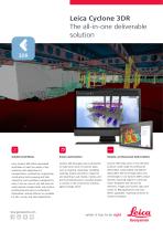
Leica Cyclone 3DR The all-in-one deliverable solution Guided workflows Smart automation Simple, professional deliverables Leica Cyclone 3DR offers specialised workflows to meet the needs of key industries with applications in transportation, architecture, engineering, construction land surveying and tank inspection. Each workflow is designed for ease of use so users of any skill level can easily execute complex tasks and produce professional and easy-to-understand deliverables. Special editions are available for AEC, survey, and plant applications. Cyclone 3DR leverages smart automation to make short work of common tasks such as cleaning, classifying, modelling, meshing, feature extraction, inspection and reporting. Load models, meshes and points simultaneously to visualise designs in context or QA construction activities against design intent. Cyclone 3DR helps users of any skill level produce a wide range of professional deliverables. Easily publish standalone deliverables like fly-through videos and orthoimages or use Cyclone 3DR’s unique dynamic reporting engine to customise report templates with 2D and 3D elements, images and numeric data, BCF issues for BIM applications and more. Where applicable, reporting conforms to industry standards.
Open the catalog to page 1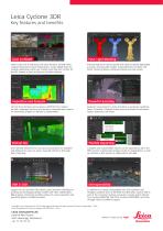
Scan to Model Import LGSx and all industry point cloud formats. Arrange them using AI-based point cloud classification. Create digital twins for multiple applications with user-friendly tools like Scan to Plan for the AEC market or Scan to Pipe for the Plant industry. Inspection and Analysis Control Floor Flatness and Levelness (ASTM E1155). Inspect tunnels, roadways and more and produce comprehensive reports for immediate analysis or delivery to stakeholders. Robust QA User-defined tolerances for accuracy and precision are analysed and delivered to users for quick, visual QA checks or thorough...
Open the catalog to page 2All Leica Geosystems catalogs and technical brochures
 Leica Captivate DS EN
2 Pages
 Leica Pegasus TRK100
4 Pages
 Leica GR30 & GR50
4 Pages
 Leica GR30 / GR50 Data Sheet
2 Pages
 Leica LOC8 DS EN
2 Pages
 Leica Rugby CLA-ctive & CLH
2 Pages
 Leica GM30 FLY en
2 Pages
 Leica GM30 DS en
2 Pages
 Leica RTC360 LT Data Sheet
2 Pages
 Leica Flexline TS10 DS EN
2 Pages
 Leica Flexline Series DS EN
2 Pages
 ScanCrete Solution Flyer
2 Pages
 Leica Disto & Leica Lino
32 Pages
 Leica iCON PA10 DS
4 Pages
 Leica PowerBlade Flyer
2 Pages
 Leica MCH100 Flyer
2 Pages
 Leica iCON grade Brochure
8 Pages
 Pegasus Backpack BRO
6 Pages
 Leica Zeno Mobile Data Sheet
2 Pages
 Leica Zeno Connect Flyer
2 Pages
 Pegasus Manager BRO
4 Pages
 Pegasus Swift DS
2 Pages
 Pegasus Swift BRO
6 Pages
 Pegasus Two Ultimate BRO
3 Pages
 Pegasus Two Ultimate DS
2 Pages
 Leica DS2000 starter kit FLY
2 Pages
 Leica Viva GS10 Data Sheet
2 Pages
 Leica Piper Series
2 Pages
 Leica BLK2GO Spec Sheet
2 Pages
 Leica Viva GS14 Data Sheet
2 Pages
 Leica iCONsite foremen
2 Pages
 Leica iCON gps 80 Contractor
6 Pages
 Leica iCON gps 80 OEM
6 Pages
 Leica iCON build
4 Pages
 Leica iCON site Brochure
4 Pages
 Leica GS07 DS EN
2 Pages
 Leica GS18 DS EN
2 Pages
 Leica CS20 DS EN
2 Pages
 Leica CS30 DS EN
2 Pages
 Leica CS35 DS EN
2 Pages
 Leica Infinity Data Sheet
2 Pages
 Leica Viva GS16 Data Sheet
2 Pages
 Leica GS18 I data sheet
2 Pages
 Leica TS16 DS
2 Pages
 Leica TS13 DS EN
2 Pages
 Leica Nova TS60 DS EN
2 Pages
 Leica Nova MS60 DS EN
2 Pages
 Leica FlexLine TS07
1 Page
 Leica ULTRA DS
2 Pages
 Leica ULTRA BRO
4 Pages
 Detection Campus BRO
4 Pages
 Leica TruView Cloud Flyer
2 Pages
 Leica Rugby 600 Series
4 Pages
 Leica Cyclone Cloud Flyer
2 Pages
 Leica CloudWorx for AutoCAD
2 Pages
 Leica iCON gps 60
4 Pages
 Leica iCON gps 70 Series
4 Pages
 Leica M-Com Brochure
4 Pages
 Leica GS18 T GNSS RTK Rover
4 Pages
 Leica ConX Flyer
2 Pages
 Leica Active Assist Flyer
2 Pages
 Leica iCON CC80 Flyer
2 Pages
 Leica iCON roller Flyer
2 Pages
 Leica PowerDigger Lite Flyer
2 Pages
 Leica LS Digital Levels
3 Pages
 Leica GeoMoS Brochure
3 Pages
 Leica AR10
2 Pages
 Leica GM10
2 Pages
 Leica AR25
2 Pages
 Leica GeoMoS Adjustment
2 Pages
 Leica GeoMoS Now
2 Pages
 Leica AR20 Flyer
2 Pages
 Leica Nova TS60
3 Pages
 Leica VADASE
2 Pages
 Leica iCON grade iGG4
4 Pages
 Leica iCON telematics
2 Pages
 AR25 Choke Ring Antenna
2 Pages
 Leica Nova TM50
4 Pages
 Leica TM6100A
6 Pages
 Leica Digicat i-Series
8 Pages
 Leica Absolute Tracker AT402
16 Pages
 Leica T-Scan TS50A brochure
4 Pages
 Leica TDRA6000
8 Pages
 Leica 3D Disto
22 Pages
 Leica Geo Office
3 Pages
 Leica Viva
5 Pages
 Leica SmartWorx Viva
3 Pages
 PROTECT by Leica Geosystems
8 Pages
 Leica Digicat xf-Series
12 Pages
 Leica NA2 / NAK2
8 Pages


Archived catalogs
 Leica Viva GS25 Data Sheet
2 Pages
 Leica Zeno GIS
3 Pages
 Leica Exchange Flyer
2 Pages
 Leica Viva GS15 Data Sheet
2 Pages
 Leica Viva GS15 Brochure
4 Pages
 Leica Nova MS60 Brochure
3 Pages
 Leica Viva TS16 Brochure
3 Pages
 Leica Viva GS16 Brochure
4 Pages
 Leica iCONstruct Software
2 Pages
 Leica iCON CC66
2 Pages
 Leica iCON builder 60
4 Pages
 Leica iCONtrol
4 Pages
 Leica iCON robot 60
4 Pages
 Leica iCON robot 50
2 Pages
 Leica Infinity Brochure
4 Pages
 Leica FlexLine TS02plus
2 Pages
 Leica Zeno 20 Brochure
5 Pages
 Leica DX Manager Flyer
2 Pages
 Leica Detection Campus
2 Pages
 Leica Detection Solutions
4 Pages
 Leica ULTRA
4 Pages
 Construction Catalogue
84 Pages
 Leica MultiWorx Data Sheet
2 Pages


- Digital imager
- Management software solution
- Automation software solution
- Process software
- Real-time software
- Windows software
- Cloud-based software
- Control software
- Touch screen tablet
- Wireless tablet
- Design software solution
- Monitoring software solution
- Rugged tablet
- 3D software solution
- Measurement software
- Interface software
- WiFi tablet
- Visualization software solution
- Quality software