
- Catalogs
- Leica Geosystems
- Construction Catalogue

Construction Catalogue

Construction Catalogue
- Laser Distance Meters: The Leica DISTO™ family includes models like D1, D2, X3, X4, and S910, featuring Bluetooth® Smart and high accuracy.
- Construction Lasers: Models like Leica Rugby CLA/CLH/CLI and the 600 Series are designed for robust environments.
- Optical and Digital Levels: The Leica NA and Sprinter series offer precise leveling solutions.
- Total Stations and GNSS Sensors: The Leica iCON series provides advanced site layout and measurement tools.
- Detection Systems: Products like Leica DSX and DS2000 offer underground utility detection and mapping.
Catalog excerpts
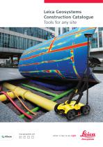
Leica Geosystems Construction Catalogue Tools for any site PART OF HEXAGON
Open the catalog to page 1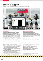
Service & SupportStrongest warranty and calibration certification offeringPROTECT by Leica Geosystems No Cost Period Certified Quality Lifetime Warranty Swiss Technology Leica CalMaster Professional calibration for maximum precision Construction sites are harsh environments and put incredible strain on lasers. In the majority of construction projects, lasers face so many impacts that their accuracy can no longer be guaranteed. This can cause inaccuracy and thus, application mistakes may occur. As an example, a wrong reference height during concrete pouring can lead to structural and security...
Open the catalog to page 2
Laser Distance Meters
Open the catalog to page 3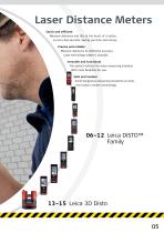
Laser Distance Meters Quick and efficient Measure distances and tilts at the touch of a button, in just a few seconds. Saving you time and money. Precise and reliable Measure distances to millimetre accuracy. Laser technology makes it possible. Versatile and functional The perfect solution for every measuring situation. With more flexibility for you. Safe and modern Avoid dangerous measuring situations at work. Use today’s modern technology. 06–12 Leica DISTO™ Family
Open the catalog to page 5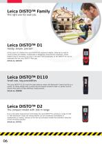
Leica DISTO™ Family The right one for each job Leica DISTO™ D1 Handy, simple, precise! At the touch of a button the Leica DISTO™ D1 measures heights, distances as well as niches quickly and reliably. Complicated or dangerous measurement situations, where ladders may be necessary, are now in the past. The functionality of the DISTO™ D1 can be extended with the Leica DISTO™ Plan app. Article no. 843418 Leica DISTO™ D110 Small size, big possibilities The Leica DISTO™ D110 is the first laser distance meter with Bluetooth® Smart that fits to a pocket. Its handy design with a pocket clip and simple...
Open the catalog to page 6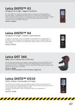
Leica DISTO™ X3 Designed for tough, rugged conditions The Leica DISTO™ X3 combines innovative distance measurement technology with a site-proof design. It withstands drop tests from up to 2 meter and is dust tight and jet water protected to IP 65 standards. In combination with the Leica DST 360 adapter it allows for Point-to-Point measurements and all measured data is easily documented and visualised with the Leica DISTO™ Plan app. Article no. 850833 Leica DISTO™ X4 Designed for bright, outdoor environments In addition to all features of the Leica DISTO™ X3, the DISTO™ X4 is equipped with a Pointfinder...
Open the catalog to page 7
Leica DISTO™ D810 touch The smartest solution to measure and document The Leica DISTO™ D810 touch is the world's first laser distance meter with a touch screen and revolutionary "measure with a picture” feature. The integrated camera can be used to take pictures and download them to a computer. The high level of functionality is perfectly completed by the smart app Leica DISTO™ Plan. Article no. 792297 Leica DISTO™ S910 Measure anything from anywhere The Leica DISTO™ S910 is worldwide the first laser distance meter with the revolutionary P2P Technology. Measure fast and easily distances between...
Open the catalog to page 8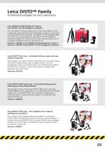
Leica DISTO™ Family Professional packages for each application Leica DISTO™ X3 P2P-Package for indoors Leica DISTO™ X4 P2P-Package for outdoors The Leica DISTO™ X-Series comes with the DST 360 adapter and the compact but sturdy tripod TRI 120. Everything is stored in a very robust case protected to IP 67 standards. The DISTO™ X3 P2P-package allows for Point-to-Point measurements. The DISTO™ X4 P2P-package is especially designed for outdoor Point-to-Point measurements, due to the digital Pointfinder camera of the DISTO™ X4. Article no. 887687 (Leica DISTO™ X3 P2P-Package for indoors) Article no....
Open the catalog to page 9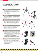
Leica DISTO™ Family Accessories supplied with / optional TRI 70 Tripod The small portable tripod is intended for everyday use. Its features include easy fine adjustment and a bubble level. Extendible length from 0.40 m to 1.15 m. Ideal with the FTA360 or FTA360-S adapter. Article no. 794963 Quality tripod with bubble level, very easy fine adjustment. Extendable length from 0.70 m to 1.74 m. Article no. 757938 TRI 120 Tripod Twist locks for the legs are making this tripod even more stable. The 180° foldable legs are making it ultimately compact. Ideal for any tripod adapter for all Leica DISTO™...
Open the catalog to page 10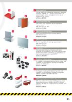
GZM3 Target Plate The new target plate is the perfect accessory for measuring templates, worktops etc. – wherever shapes have to be captured. Edges, curves, markings and corners can be measured in any position. GZM26 Target Plate, large Grey side for short and brown side for long distance measurements. Size: 210 × 297 mm (A4). Article no. 723385 GZM27 Stick-On Target Plate Target plate held in place with kneading adhesive. Size: 45 × 100 mm. GZM30 Target Plate Stick-on target plates for placing on ground markers. Size: 274 × 197 mm. Article no. 766560 TPD 100 Kit The target plate for improved...
Open the catalog to page 11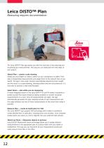
Leica DISTO™ Plan Measuring requires documentation The Leica DISTO™ Plan app assists you with the vital task of documenting and visualising your measurements. This way you can easily plan the next steps of your project. Sketch Plan — create a scale drawing Simply use your fingers to create a sketch on your smartphone or tablet. Then take corresponding measurements and assign them to the relevant lines of you sketch. The app’s ‘auto-scale’ function automatically adjusts the lines’ length and the result is a scaled drawing, showing surface area and circumference. It is that easy to produce a CAD...
Open the catalog to page 12
Leica 3D Disto Recreating the real world The high-precision Leica 3D Disto is used whenever the use of conventional measuring tools is only possible with a great deal of time and effort. With the various measurement functions you can record all spatial situations precisely and use the data afterwards in your customary software environment. With the realistic data you can produce the final parts directly. The time-consuming template and modification work during installation is no longer necessary. The fully digitalised workflow saves valuable time.
Open the catalog to page 13All Leica Geosystems catalogs and technical brochures
 Leica Captivate DS EN
2 Pages
 Leica Pegasus TRK100
4 Pages
 Leica Cyclone 3DR Data Sheet
2 Pages
 Leica GR30 & GR50
4 Pages
 Leica GR30 / GR50 Data Sheet
2 Pages
 Leica LOC8 DS EN
2 Pages
 Leica Rugby CLA-ctive & CLH
2 Pages
 Leica GM30 FLY en
2 Pages
 Leica GM30 DS en
2 Pages
 Leica RTC360 LT Data Sheet
2 Pages
 Leica Flexline TS10 DS EN
2 Pages
 Leica Flexline Series DS EN
2 Pages
 ScanCrete Solution Flyer
2 Pages
 Leica Disto & Leica Lino
32 Pages
 Leica iCON PA10 DS
4 Pages
 Leica PowerBlade Flyer
2 Pages
 Leica MCH100 Flyer
2 Pages
 Leica iCON grade Brochure
8 Pages
 Pegasus Backpack BRO
6 Pages
 Leica Zeno Mobile Data Sheet
2 Pages
 Leica Zeno Connect Flyer
2 Pages
 Pegasus Manager BRO
4 Pages
 Pegasus Swift DS
2 Pages
 Pegasus Swift BRO
6 Pages
 Pegasus Two Ultimate BRO
3 Pages
 Pegasus Two Ultimate DS
2 Pages
 Leica DS2000 starter kit FLY
2 Pages
 Leica Viva GS10 Data Sheet
2 Pages
 Leica Piper Series
2 Pages
 Leica BLK2GO Spec Sheet
2 Pages
 Leica Viva GS14 Data Sheet
2 Pages
 Leica iCONsite foremen
2 Pages
 Leica iCON gps 80 Contractor
6 Pages
 Leica iCON gps 80 OEM
6 Pages
 Leica iCON build
4 Pages
 Leica iCON site Brochure
4 Pages
 Leica GS07 DS EN
2 Pages
 Leica GS18 DS EN
2 Pages
 Leica CS20 DS EN
2 Pages
 Leica CS30 DS EN
2 Pages
 Leica CS35 DS EN
2 Pages
 Leica Infinity Data Sheet
2 Pages
 Leica Viva GS16 Data Sheet
2 Pages
 Leica GS18 I data sheet
2 Pages
 Leica TS16 DS
2 Pages
 Leica TS13 DS EN
2 Pages
 Leica Nova TS60 DS EN
2 Pages
 Leica Nova MS60 DS EN
2 Pages
 Leica FlexLine TS07
1 Page
 Leica ULTRA DS
2 Pages
 Leica ULTRA BRO
4 Pages
 Detection Campus BRO
4 Pages
 Leica TruView Cloud Flyer
2 Pages
 Leica Rugby 600 Series
4 Pages
 Leica Cyclone Cloud Flyer
2 Pages
 Leica CloudWorx for AutoCAD
2 Pages
 Leica iCON gps 60
4 Pages
 Leica iCON gps 70 Series
4 Pages
 Leica M-Com Brochure
4 Pages
 Leica GS18 T GNSS RTK Rover
4 Pages
 Leica ConX Flyer
2 Pages
 Leica Active Assist Flyer
2 Pages
 Leica iCON CC80 Flyer
2 Pages
 Leica iCON roller Flyer
2 Pages
 Leica PowerDigger Lite Flyer
2 Pages
 Leica LS Digital Levels
3 Pages
 Leica GeoMoS Brochure
3 Pages
 Leica AR10
2 Pages
 Leica GM10
2 Pages
 Leica AR25
2 Pages
 Leica GeoMoS Adjustment
2 Pages
 Leica GeoMoS Now
2 Pages
 Leica AR20 Flyer
2 Pages
 Leica Nova TS60
3 Pages
 Leica VADASE
2 Pages
 Leica iCON grade iGG4
4 Pages
 Leica iCON telematics
2 Pages
 AR25 Choke Ring Antenna
2 Pages
 Leica Nova TM50
4 Pages
 Leica TM6100A
6 Pages
 Leica Digicat i-Series
8 Pages
 Leica Absolute Tracker AT402
16 Pages
 Leica T-Scan TS50A brochure
4 Pages
 Leica TDRA6000
8 Pages
 Leica 3D Disto
22 Pages
 Leica Geo Office
3 Pages
 Leica Viva
5 Pages
 Leica SmartWorx Viva
3 Pages
 PROTECT by Leica Geosystems
8 Pages
 Leica Digicat xf-Series
12 Pages
 Leica NA2 / NAK2
8 Pages


Archived catalogs
 Leica Viva GS25 Data Sheet
2 Pages
 Leica Zeno GIS
3 Pages
 Leica Exchange Flyer
2 Pages
 Leica Viva GS15 Data Sheet
2 Pages
 Leica Viva GS15 Brochure
4 Pages
 Leica Nova MS60 Brochure
3 Pages
 Leica Viva TS16 Brochure
3 Pages
 Leica Viva GS16 Brochure
4 Pages
 Leica iCONstruct Software
2 Pages
 Leica iCON CC66
2 Pages
 Leica iCON builder 60
4 Pages
 Leica iCONtrol
4 Pages
 Leica iCON robot 60
4 Pages
 Leica iCON robot 50
2 Pages
 Leica Infinity Brochure
4 Pages
 Leica FlexLine TS02plus
2 Pages
 Leica Zeno 20 Brochure
5 Pages
 Leica DX Manager Flyer
2 Pages
 Leica Detection Campus
2 Pages
 Leica Detection Solutions
4 Pages
 Leica ULTRA
4 Pages
 Leica MultiWorx Data Sheet
2 Pages


- Digital imager
- Management software solution
- Automation software solution
- Process software
- Real-time software
- Windows software
- Computer-aided design software
- Cloud-based software
- Control software
- Touch screen tablet
- Wireless tablet
- Design software solution
- Monitoring software solution
- 3D software solution
- Measurement software
- Interface software
- WiFi tablet
- Visualization software solution
- Quality software
- VirtualExpo Group
- Our Partners
- Recruitment
- Testimonials