
- Catalogs
- Keii Electro Optics Technology Co.,Ltd
- Keii UAVs IR Inspection System/ DJI M200/ Thermal Imaging/ industrial/ Powerline/ Solor panel / rougfing inspection


- Company
- Products
- Catalogs
- News & Trends
- Exhibitions
Keii UAVs IR Inspection System/ DJI M200/ Thermal Imaging/ industrial/ Powerline/ Solor panel / rougfing inspection

Keii UAVs IR Inspection System/ DJI M200/ Thermal Imaging/ industrial/ Powerline/ Solor panel / rougfing inspection
- Thermal Sensitivity: 0.05℃ at 30℃
- Optical Focus: 25mm lens focal length, fixed focus at 10m
- Digital Zoom: 4x, 8x
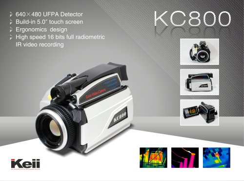
- Detector Type: Focal Plane Array (FPA), uncooled microbolometer 640×480 pixels
- Image Frequency: 50Hz/60Hz
- Spectral Range: 7~14 µm
- Field of View: 25°×18.7°
- Spatial Resolution (IFOV): 0.68 mrad
- Temperature Range: -20℃ to +150℃
- Accuracy: ±2℃ or ±2% of reading
- Max. Temp Tracking: Automatically captures max. temperature and displays specific data in real-time
- GPS Position (Optional): Real-time overlay of geographic coordinates and infrared data
Gimbal Specifications
- Control Accuracy: ±0.01°
- Movement Range: Pitch ±90°, Yaw ±150°
- Control Interface: PWM/S-BUS/Serial port
- Storage Mode: 16 bits full dynamic infrared temperature data to SD card
- Transmission: Supports HDMI & SD video signal, point to point & single to multi-receiving mode
- Transmission Distance: Up to 10km with high gain tablet directive antenna
Battery Specifications
- Model: TB50
- Capacity: 4280 mAh
- Voltage: 22.8 V
- Type: LiPo 6S
- Energy: 97.58 Wh
- Weight: Approx. 520 g
- Operating Temperature: -20℃ to 45℃
- Charging Temperature: 5℃ to 40℃
- Max Charging Power: 180 W
Infrared Camera Specifications
- Design: Specially designed for light UAV
- Recording: 16 bits full radiometric real-time recording
- Resolution: 640x480 pixels or higher
- Lens: 25mm, dual FOV lens module (Optional)
- Overlay: Real-time geographic and coordinates information
DJI M200 Specifications
- Dimensions: 887×880×378 mm (Unfolded), 716×220×236 mm (Folded)
- Max Takeoff Weight: 6.14 kg
- Max Payload: 2.34 kg (Standard battery), 1.61 kg (Optional battery)
- Max Speed: P mode: 17 m/s, S mode/A mode: 23 m/s
- Flight Time: 27 min (No Payload), 13 min (Takeoff Weight 6.14 kg)
- Max Service Ceiling: 2500 m
- Wind Resistance: 10 m/s
- Rain Resistance: IP43
Environmental Specifications
- Operating Temperature Range: -20°C to 50°C
- Storage Temperature Range: -40°C to 70°C
- Humidity: 10% to 95%, non-condensing
Gimbal Control
- Accuracy: ±0.01°
- Movement Range: Pitch -90~+30°, Course ±150°, Roll ±25°
- Interface: PWM/S-BUS/Serial port
- Storage: 16 bits full radiometric infrared temperature data to SD card
Physical Characteristics
- Size: 99 x 54 x 65 mm
- Weight: ≤210g (Excluding gimbal); ≤490g (Including 3 axes stabilized gimbal)
Catalog excerpts

DJI M200 SPECIFICATION Light Multi-Rotor UAV Thermal Imaging System (M200 + HL - 640S) Infrared thermal image performance parameters Equip with HD image and digital data transmission task mo ■ Support HDMI & SD video signal ■ Support point to point & single transmitting to multi-receiving mode ■ High gain tablet directive antenna, transmission distance can reach 10km Max Payload 2.34 kg(Standard battery) ,1.61 kg(Optional battery) Max horizontal speed P mode: 17 m/s , S mode/Amode: 23 m/s Max Flight Time (Standard battery) 27 min (No Payload) , 13min (Takeoff Weight 6.14 kg) Max Flight Time (Optional battery) 38 min (No Payload) , 24 min (Takeoff Weight 6.14 kg) Max Service Ceiling Above Sea Level 2500 m HL-640S SPECIFICATION Gimbal Infrared thermal image performance parameters Gimbal control accuracy: ±0.01° Movement range: Pitch±90° , Yaw ±150° Control interface: PWM/S-BUS/Serial port Storage mode: 16 bits full dynamic infrared temp. data to SD card Infrared Camera ■ Special designed for light UAV ■ 16 bits full radiometric real time recording ■ 640x480 pixels or higher resolution detector ■ 25mm lens, dual FOV lens module (Optional) ■ Real time overlay of geographic and coordinates information, synchronous recording ■ Complete task system configuration Thermal sensitivity Optical focus Digital Zoom Detector type Image frequency Spectral range Field of view Spatial resolution ( IFOV ) Temperature range Accuracy Max. temp. automatically tracking GPS Position(Optional) IMAGE PRESENTATION Battery (Standard) ■ Model: TB50 ■ Capacity: 4280 mAh ■ Voltage: 22.8 V ■ Battery type: LiPo 6S ■ Energy: 97.58 Wh ■ Battery weight: Appro. 520 g ■ Operating temp.: -20°C to 45°C ■ Charging temp.: 5°C to 40°C ■ Max Charging power: 180 W Composite video Palette ENVIRONMENTAL SPECIFICATION Operating temp. range Storage temp.range Humidity Gimbal Control accuracy Movement range Control interface Storage Working voltage Average power consumption PHYSICAL CHARACTERISTICS Size Weight 0.05oC (at 30oC) 25 mm lens focal length, fix focus(10m away free focus) 4x ,8x Focal Plane Array ( FPA ), uncooled microbolometer 640X480 pixels 50 Hz/60 Hz 7~14 ^ 25°X18.7° 0.68 mrad -20°C ~ + 150C ±2°C or ±2% of reading Automatically capturing max. temp. and showing specific data in display in-real time GPS geographic coordinate information and infrared data real-time overlay, synchronous record NTSC / PAL Composite video white hot / black hot / iron -20°C ~ 50°C -40°C ~ 70°C Operating and storage 10% to 95%, non-condensing ±0.01° pitch-90~+30°, course±150°,roll±25° PWM/S-BUS/Serial port 16 bits full radiometric infrared temp. data storage into SD card 11~50V 6W ■ 99 x 54 x 65 mm <210g (Excluding gimbal) ;<490g (Including 3 axes sta
Open the catalog to page 1All Keii Electro Optics Technology Co.,Ltd catalogs and technical brochures
 Keii Company Profile
1 Page


Archived catalogs
 PB-640 EN
2 Pages
 HS400-320 & HS100-640
2 Pages
 MC1-640KZ
2 Pages




- Digital imager
- Industrial camera module
- Monitoring camera system
- USB camera module
- Detection camera system
- Waterproof camera module
- Compact imager
- HD camera module
- Thermographic camera
- Temperature-controlled camera
- USB 3.0 camera module
- High-performance imager
- Portable camera system
- Spark optical emission camera module
- High-sensitivity video camera
- Megapixel imager
- Lightweight imager
- Outdoor camera module
- Measuring imager