- Catalogs
- Hunan Puqi Geologic Exploration Equipment Institute (Common Partnership)
- Water Detector Operation & Analysis
Water Detector Operation & Analysis
1 /6Pages
Water Detector Operation & Analysis
1 /6Pages
Catalog excerpts

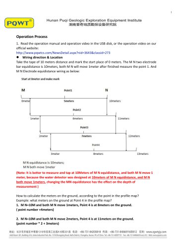
Operation Process 1. Read the operation manual and operation video in the USB disk, or the operation video on our official website: http://www.pqwtcs.com/NewsDetail.aspx?nid=3643&classid=273 Wiring direction & Location Take the tape of 10 meters distance and mark the start place of 0 meters. The M N two electrode bar equidistance is 10meters, both M N will move 1meter after finished measure the point 1. And M N Electrode equidistance wiring as below: (Note: It is better to measure and tap at 10Meters of M N equidistance, and both M N move 1 meter, because the water detector was designed at 10meters of M N equidistance, and M N both move 1meters. changing the MN equidistance has the effect on the depth of measurement ) How to calculate the meters on the ground, according to the point in the profile map? Example: what meters on the ground at Point 4 in the profile map? 1. M N=10M and both M N move 1meters, Point 4 is at 8meters on the ground. ( point number +4meters) 2. M N=10M and both M N move 2meters, Point 4 is at 11meters on the ground. (point number * 2 + 3meters)
Open the catalog to page 1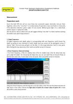
Measurement:Preparatory work Insert the both MN into soil (or cross these two connected copper electrodes and put them together), click on the " Line Test" in 3 modes below of operation screen and hold on 2-3seconds, if the detection indicator ( green ) light, it's Line normal. Without green light, It is a cable fault, need to repair or replace the cable. (For dry land or stone surface land, we will suggest clicking "Line Test" to check machine working line before each point measurement) In Single Frequency each depth option is corresponding with one frequency, could choose the depth according...
Open the catalog to page 2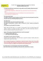
^ ©"] Hunan Puqi Geologic Exploration Equipment Institute 3, Profile Survey:(Accuracy measurement, using profile survey for finding underground water) Tips before Measurement: 1. Avoid the high-voltage(above 1000v) power lines/ signal tower around the measurement place. 2. The Two electrode bar doesn't touch the underground metal when measurement. 3. Be far away from the highway, train It is better to measure at least 15 points for each line and no more than 30 points for each line. (15 points show the completed geological structure ) The Gain function only works for weak electrical signal The...
Open the catalog to page 3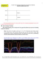
(The three parallel line show the similar profile map of the underground geological structure, this is better to pick the borehole point) After finishing detecting, How to analysis the Curve graph and profile map to point out the drilling location for reference? Step1, First observe the curve to find the "V" "L" "W" "A"(measuring point display regular a lot of falling curves, lower potential difference data, and mark the position number. (The horizontal line of Curve is measurement point, The vertical line of the curve is underground material's potential difference data(could regard as resistivity...
Open the catalog to page 4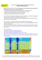
Step 2, We will observe the profile map, (The horizontal line of profile map is measurement point, The vertical line of profile map is measurement depth) 1. Blue, light blue just meaning it is low resistivity, like water, soft mud, and some metal mineral are all low resistivity, so not just this kind of color is water; 2. Yellow means the middle resistivity, like rock or something; 3. Red means the high resistivity, like the cavity or hard rock; So not each color could stand for anything, the map just could help us to analysis the geological structure, need to combine the local geological, that's...
Open the catalog to page 5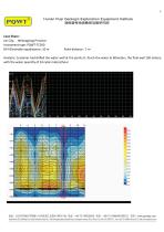
Case Share : Jixi City, Heilongjiang Province Instrument type: PQWT-TC300 M N Electrode equidistance: 10 m Point distance : 1 m Analysis: Customer had drilled the water well at the points 8, Touch the water at 60meters, the final well 150 meters, with the water quantity of 24 cubic meters/hour Add: Room 301, Building A16, Jiahai Industrial Park, No, 1318 Zhongqing Road, Kaifu District, Changsha, Hunan, PR. of China Tel: +86-731 -82237112 Fax: +86-731 -84066916 ext. 812 Web: www.pqwtcs.com
Open the catalog to page 6All Hunan Puqi Geologic Exploration Equipment Institute (Common Partnership) catalogs and technical brochures
 PQWT Water Detector
11 Pages
 Water Detector Case Share
52 Pages
- Leak monitor
- Industrial detector
- Portable detector
- Gas leak detector
- Detector with digital display
- Real-time detector
- Process detector
- Portable leak detector
- Automatic detector
- Leak detector with integrated display
- Liquid leak detector
- LED detector
- Water leak detector
- Power detector
- Detector with LCD display
- Acoustic leak detector
- Leak detector with digital display
- Electronic leak detector
- Calibration detector
- Liquid detector