
- Catalogs
- Hi-Target Surveying Instrument Co.,Ltd
- V700S SLAM RTK-Brochure-EN-20251020(s).pdf


- Company
- Products
- Catalogs
- News & Trends
- Exhibitions
V700S SLAM RTK-Brochure-EN-20251020(s).pdf
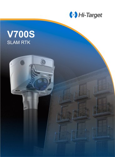
V700S SLAM RTK-Brochure-EN-20251020(s).pdf
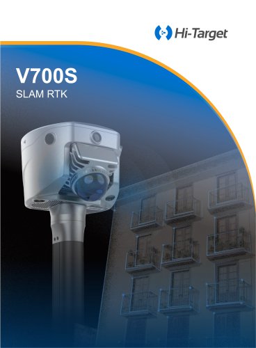
The SLAM RTK V700S is a high-precision surveying instrument designed for robust geospatial data acquisition. It integrates GNSS and SLAM technologies to provide accurate positioning even in challenging environments.
Key Features
- Full-Constellation Tracking: Supports 1408 channels with a new GNSS SoC chip for low power consumption and extended battery life. Advanced multi-frequency anti-interference technology ensures strong signal reception and high-quality data.
- Innovative Industrial Design: Utilizes laser point cloud and image data for real-time geospatial information acquisition, expanding GNSS applications to areas like under bridges and enclosed spaces.
- Contactless Measurement: Features Laser Reverse Positioning Technology for seamless cross-environment measurement, providing centimeter-level accuracy outdoors and laser-based positioning in GNSS-denied areas.
Applications
- Urban Renewal
- Volume Measurement
- Tunnel Surveying
- Forestry Survey
- Underground Pipelines
- Architectural Survey
Technical Specifications
- GNSS Configuration: Supports multiple satellite systems including GPS, BDS, GLONASS, GALILEO, QZSS, NavIC, and SBAS.
- Accuracy: Horizontal accuracy of 2.5 mm + 0.1 ppm RMS and vertical accuracy of 3.5 mm + 0.4 ppm RMS under optimal conditions.
- Laser Scanner: Provides a point measurement rate of 200,000 pts/sec with a range of 0.1 to 70 meters.
- Power: Built-in lithium battery with up to 4 hours of operation in RTK mode and up to 2 hours in SLAM mode. External battery extends operation time significantly.
Software
- Hi-Survey Field Software: Offers real-time solutions and visualization with a high-performance laser point cloud and image processing engine.
- Office Software for Post-processing: Hi-LiDAR software refines real-time data, providing sub-2 cm thickness point clouds and advanced section visualization.
Environmental and Physical Specifications
- Operating Temperature: -40℃ to +70℃
- Storage Temperature: -20℃ to +55℃
- IP Rating: IP64 for dust and water resistance.
Conclusion
The SLAM RTK V700S is a versatile and advanced surveying tool suitable for a wide range of applications, offering high accuracy and reliability in various environmental conditions.
Catalog excerpts
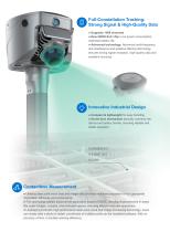
• Supports 1408 channels • New GNSS SoC chip: Low power consumption, extended battery life. • Advanced technology: Advanced multi-frequency anti-interference and adaptive filtering technology ensures strong signal reception, high-quality data and excellent accuracy. Compact & lightweight for easy handling. crew-lock mechanism securely connects the device and battery handle, ensuring reliable and stable operation. Contactless Measurement • Utilizing laser point cloud data and image data provides real-time acquisition of rich geospatial information efficiently and conveniently. • This technology...
Open the catalog to page 2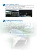
Unified Coordinate Framework Unified Coordinate Framework • RTK + SLAM Fusion: V700S delivers real-time centimeter-level positioning outdoors while automatically aligning point cloud data, ensuring unified coordinate output (BLH/NEH). • Control-free scanning: V700S requires no control points, allowing users to scan freely without returning to previous locations - dramatically improving on-site efficiency. Laser Reverse Positioning Technology: Precision Measurement without Signal Hi-Target's innovative Laser Reverse Positioning Technology enables seamless cross-environment measurement. Outdoors,...
Open the catalog to page 3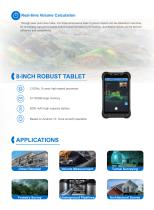
Real-time Volume Calculation Through laser point cloud data, rich three-dimensional data of ground objects can be obtained in real time. By leveraging high-performance Android-based processing technology, quantitative results can be derived efficiently and conveniently. 8-INCH ROBUST TABLET 2.0GHz, 8 cores high-speed processor 6+128GB large memory 8200 mAh high capacity battery Based on Android 10, more smooth operation Urban Renewal Volume Measurement Tunnel Surveying Forestry Survey Underground Pipelines Architectural Survey
Open the catalog to page 4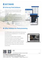
cSOFTWARE□ Hi-Survey Field Software • High-performance laser point cloud & image processing engine for real-time solutions and visualization. • Precision heat map display allows users to monitor accuracy in real time. • Integrates industry-leading CAD & real-scene engines for an intuitive, visual measurement and layout experience. • Hi-LiDAR software refines real-time data, delivering point clouds with sub-2 cm thickness and <1 cm relative measurement precision. • Automated excavation analysis: Calculates over/under-excavation for tunnel sections, enabling construction progress tracking and validation....
Open the catalog to page 5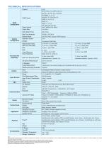
[1] The measurement accuracy, precision, reliability and initialization time depend on various factors, including tilt angle, number of satellites, geometric distribution, observation time, atmospheric conditions and multi-path validation, etc. The data are derived under normal conditions. [2] Irregular operations such as rapid rotation and high-intensity vibration may affect the inertial navigation accuracy. [3] The results are the accuracy obtained in laboratory scenarios, and some scenarios may have accuracy deviations. [4] The battery operating time is related to the operating environment,...
Open the catalog to page 6All Hi-Target Surveying Instrument Co.,Ltd catalogs and technical brochures
 HD-Lite
1 Page
 Hi-Target/USV/ iBoat BS12
2 Pages
 Hi-Target catalog-20230907s
20 Pages
 Hi-Target/GNSS Receiver/V500
2 Pages
 Hi-Target/GNSS Receiver/vRTK
4 Pages
 Hi-Target/GNSS Receiver/V200
2 Pages
 Hi-Target/USV/ iBoat BS3
2 Pages
 Hi-Target/Auto Level/ HT-32
2 Pages



Archived catalogs

- Management software solution
- Analysis software solution
- Process software
- Real-time software
- Windows software
- Touch screen tablet
- Wireless tablet
- Rugged tablet
- Industrial software
- 3D software solution
- Interface software
- Bluetooth tablet
- WiFi tablet
- GNSS tablet
- Industrial tablet
- Android tablet
- Real-time monitoring module
- Waterproof tablet
- Measurement monitoring module
- Tablet with NFC reader