- Catalogs
- Hi-Target Surveying Instrument Co.,Ltd
- V600L-Brochure-EN-20250929(s)
- Company
- Products
- Catalogs
- News & Trends
- Exhibitions
V600L-Brochure-EN-20250929(s)
1 /4Pages
V600L-Brochure-EN-20250929(s)
1 /4Pages
Catalog excerpts
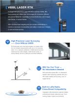
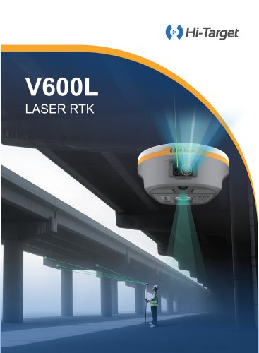
T—■V600L LASER RTK Hi-Target next-generation Laser RTK that combines GNSS, IMU, dual-camera, and visible laser technologies for immersive, efficient, and precise fieldwork—especially in environments like under bridges, near fences, or across ditches. With visualized laser targeting and non-contact measurement, it unlocks a new level of accessibility and safety in obstructed, complex, or semi-enclosed terrains. High-Precision Laser Surveying -Even Without GNSS By fusing laser and visual technologies, our system delivers non-contact measurements with up to 2 cm accuracy within 10 m. Operate confidently...
Open the catalog to page 2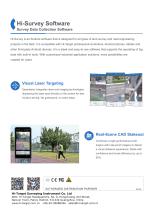
Survey Data Collection Software Hi-Survey is an Android software that is designed for all types of land survey and road engineering projects in the field. It is compatible with Hi-Target professional controllers, Android phones, tablets and other third-party Android devices. It is a sleek and easy-to-use software that supports the operating of big data with built-in tools. With customized industrial application solutions, more possibilities are created for users. Visual Laser Targeting Seamlessly Integrates laser and Imaging technologies displaying the laser spot directly on the screen for fast,...
Open the catalog to page 3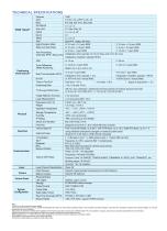
[1]QZSS L6 can be provided by firmware upgrade. [2IThe measurement accuracy, precision, reliability and initialization time depend on various factors, including tilt angle, number of satellites, geometric distribution, observation time, atmospheric conditions and multi-path validation, etc. The data are derived under normal conditions. [3] Aecuracies are dependent on GNSS satellite availability. Hi-Fix Positioning ends after5 minutes without differential data.Hi-Fix is not available in all regions, check with your local sales representative for more information. [4] lnregular operations such...
Open the catalog to page 4All Hi-Target Surveying Instrument Co.,Ltd catalogs and technical brochures
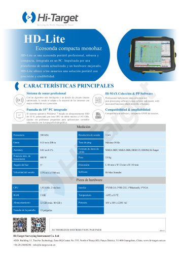 HD-Lite
1 Page
 Hi-Target/USV/ iBoat BS12
2 Pages
 Hi-Target catalog-20230907s
20 Pages
 Hi-Target/GNSS Receiver/V500
2 Pages
 Hi-Target/GNSS Receiver/vRTK
4 Pages
 Hi-Target/GNSS Receiver/V200
2 Pages
 Hi-Target/USV/ iBoat BS3
2 Pages
 Hi-Target/Auto Level/ HT-32
2 Pages


Archived catalogs

- Management software solution
- Analysis software solution
- Process software
- Windows software
- Sanxing Electric real-time software
- Touch screen tablet
- Wireless tablet
- Rugged tablet
- 3D software solution
- Industrial software
- Interface software
- Bluetooth tablet
- WiFi tablet
- GNSS tablet
- Industrial tablet
- Android tablet
- Waterproof tablet
- Real-time monitoring module
- Measurement monitoring module
- Tablet with NFC reader