- Catalogs
- Hi-Target Surveying Instrument Co.,Ltd
- Hi-Target/GNSS RTK System/ iRTK5
- Company
- Products
- Catalogs
- News & Trends
- Exhibitions
Hi-Target/GNSS RTK System/ iRTK5
1 /2Pages

Hi-Target/GNSS RTK System/ iRTK5
1 /2Pages
Catalog excerpts

PERFORMANCE SPECIFICATIONS Satellite Signals Tracked Simultaneously POSITIONING PERFORMANCE High-Precision Static Surveying the World,Mapping the Future 6V to 28V DC external power input(5-pin port), with over-discharge protection power consumption 4.4W Automatic switching between internal power and external power Internal Battery 7.4V, 6800mAh lithium-ion rechargeable and removable battery. RTK rover(UHF/Cellular) for 10 hours. Power indicator embedded. Quick charge within 3.5 hours. I/O Interface Bluetooth 4.0/2.1+ EDR, 2.4 GHz. USB 2.0 port with OTG function. 1 SMA antenna connector. 1 DC power input(5-pin). 1 SIM card slot Near Field Communication(NFC) Network Communication Full band support for cellular mobile network(LTE, WCDMA, EDGE, GPRS, GSM). 2.4GHz Wi-Fi, supports the standard protocol 802.11 b/g/n. Network RTK(in CORS) range is 20-50km. Network RTK(VRS,FKP,MAC) Internal UHF Transceiver Radio Tilt Survey Performance 2cm accuracy in the inclination of 30 degree SYSTEM CONFIGURATION Data Formats 1Hz positioning output, up to 50Hz. CMR, RTCM2.X, RTCM3.0, RTCM3.1, RTCM3.2 . Navigation outputs ASCII: NMEA-0183 GSV, AVR, RMC, HDT, VGK, VHD, ROT, GGK, GGA, GSA, ZDA, VTG, GST, PJT, PJK, BPQ, GLL, GRS, GBS. Binary: Trimble GSOF, NMEA2000 1.The hardware of this product is designed for Beidou B3 compatibility (trial version) and its firmware will be enhanced to fully support such new signals as soon as the officially published signal interface control documentation (ICD) becomes available. 2.There is no public GLONASS L3 CDMA or Galileo E6 ICD. The current capability in the receivers is based on publicly available information. 3.Developed under a License of the European Union and the European Space Agency. 4.Input only network correction. 5.Accuracies are dependent on GNSS satellite availability. Hi-Fill positioning ends after 5 minutes of radio downtime. Hi-Fill is not available in all regions, check with your local sales representative for more information. 6.RTK refers to the last reported precision before the correction source was lost and Hi-Fill started. Descriptions and Specifications are subject to change without notice AUTHORIZED DISTRIBUTION PARTNER Hi-Target Surveying Instrument Co. Ltd ADD: Building 13, Tian'An Technology Zone HQ Center, No. 555, North o
Open the catalog to page 1
Innovative Design Benefiting from the next-generation GNSS engine, unlimited communication technology and innovative designs, iRTK5, the high quality scalable GNSS receiver, provides an industryleading GNSS RTK surveying solution. Hi-RTP™ Global PPP Service V_iffL_J The correction source has been extended by Hi-RTP™ global correction service provided by Hi-Target. Enabling users to work without a base-station in rural or remote areas anywhere in the world. -Provide centimeter-level global precision -Harness all constellation signals from BDS, GLONASS, GPS, GALILEO -More than 220 reference stations...
Open the catalog to page 2All Hi-Target Surveying Instrument Co.,Ltd catalogs and technical brochures
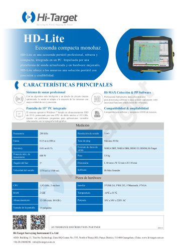 HD-Lite
1 Page
 Hi-Target/USV/ iBoat BS12
2 Pages
 Hi-Target catalog-20230907s
20 Pages
 Hi-Target/GNSS Receiver/V500
2 Pages
 Hi-Target/GNSS Receiver/vRTK
4 Pages
 Hi-Target/GNSS Receiver/V200
2 Pages
 Hi-Target/USV/ iBoat BS3
2 Pages
 Hi-Target/Auto Level/ HT-32
2 Pages


Archived catalogs

- Management software solution
- Analysis software solution
- Process software
- Windows software
- Sanxing Electric real-time software
- Touch screen tablet
- Wireless tablet
- Rugged tablet
- 3D software solution
- Industrial software
- Interface software
- Bluetooth tablet
- WiFi tablet
- GNSS tablet
- Industrial tablet
- Android tablet
- Waterproof tablet
- Real-time monitoring module
- Measurement monitoring module
- Tablet with NFC reader